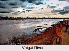
 Vaigai River is an Indian River that flows in the southern part of India. The city of Madurai in Tamil Nadu is situated on the banks of this river. The Vattaparai Falls is located on this river. Vaigai gets major feed from the Periyar Dam in Kumuli, Kerala. Water from the Periyar River in Kerala is diverted into the Vaigai River in Tamil Nadu via a tunnel through the Western Ghats.
Etymology of Vaigai River
According to Sangam literature, the Vaigai River is praised as "the river that brings water when one touches it". The river"s name is derived from "vai" meaning "to place" and "gai" meaning "hands".
Course of Vaigai River
Vaigai River flows for 150 miles (240 km) generally in the south-east direction and rarely causes floods. The Vaigai River basin in Tamil Nadu covers an area of 7,000 sqkm. The river rises in the Varusanadu hills, Periyar plateau of the Western Ghats. It then flows in the north-east direction through the Kambam Valley. The Kambam Valley lies between the Palni Hills to the north and the Varusanadu Hills in the south. From the Varusanadu Hills, the river turns in the south-east direction and flows through the Pandya Nadu region. In its central, the Vaigai flows eastward into the Vaigai reservoir at Narasingapuram. The river finally evacuates in to the Palk Strait, a 64-137 km wide channel in Ramanathapuram district.
 History of Vaigai River
Vaigai River was an important trading route in ancient times, between Madurai - the capital of the Pandyan Empire and the port town of Alagankulam on the right bank of the river.
Legend of Vaigai River
The legend of the Vaigai River involves a story that happened during the rule of Pandyan Kings. Meenakshi, the daughter of Pandyan King decided to marry Lord Shiva during her young age itself. The daughter"s wish was not accepted by her parents and later they consented to arrange the wedding for Meenakshi. On wedding day, Lord Shiva came to the ceremony without bringing any relatives and family members. The incident disappointed the Pandyan King as there was huge amount of food prepared for the bridegroom"s relatives.
Lord Shiva pointed out his friend and told that he will consume all the food. Kundodhara, the friend of Lord Shiva finished all the food and he was feeling very thirsty. All the wells and canals were not sufficient for his thirst and so Lord Shiva asked his friend to put his hand out. At this point of time, the Ganga began to flow and thus Kundodhara quenched his thirst. It is believed that the rest of waters began to flow in Madurai through the Vaigai River. Since then, the River Vaigai has become closely associated with the Chithirai festival of Meenakshi Sundareswarar Temple in Madurai.
Tributaries of Vaigai River
The major tributaries of the Vaigai River are Suruliyaru, Mullaiyaaru, Varaganadi and Manajalaru and Kridhumaal. The tributaries merge with the Vaigai River at places near the Vaigai Dam.
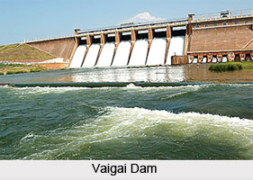
Dam on Vaigai River
The Vaigai Dam is built across the river near Andipatti, in the Theni district of Tamil Nadu. It provides water for irrigation for the Madurai district and the Dindigul district as well as drinking water to Madurai and Andipatti. Near the dam, the Government of Tamil Nadu has constructed an Agricultural Research Station for researching the growing of a variety of crops, including rice, sorghum, black gram, cowpea and cotton.
Pollution on Vaigai River
Like other rivers in India, Vaigai River also faces serious pollution issues with untreated domestic sewage and effluents being dumped into the river. In summers, the Vaigai River ends up dry very often.


