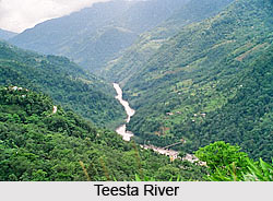
 Teesta River is a trans-Himalayan river flowing through the Indian states of Sikkim and West Bengal and Rangpur in Bangladesh. This river forms a boundary between Sikkim and West Bengal. Teesta River is a tributary of Brahmaputra River.
Geography of Teesta River
Teesta River has a total length of about 309 kilometers and it drains an area of about 12,540 square kilometers. The river has preserved good climatic and tectonics imprints along its valleys and catchment areas.
Origin and Course of Teesta River
Teesta River originates from Pahunri glacier, 7,068 meters above the mean sea level. It flows southward through gorges and rapids in the Sikkim Himalaya. The river merges with rivulets, which arise in the Thangu, Yumthang and Donkia-La ranges. It then traverses through the Rangpo town, where it forms a boundary line between Sikkim and West Bengal, up to Teesta Bazaar.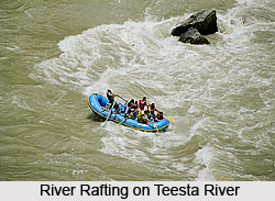 At the Teesta Suspension Bridge, the river meets its main tributary, Rangit River. At this stage, the river changes its direction and flows southwards towards West Bengal. The river approaches the plains at Sevoke and then moves towards Jalpaiguri. It reaches Rangpur district of Bangladesh before surrendering itself to the Brahmaputra River at Fulcherry.
Hydroelectric Projects and Dams Associated with Teesta River
A couple of hydroelectric projects and dams have been successfully completed on Teesta River. In 2000, Rangit III hydroelectric Project was completed on Greater Rangit River, which is a tributary of Teesta River. The Teesta-V dam construction was completed in 2007 on Teesta River. With a height of about 87 meters and length of about 176 meters, the dam generates about 510 megawatt of hydroelectric power. The other projects that have been successfully completed on Teesta River are Lower Lagyap, Upper Rongni Chhu and Mayang Chhu projects.
Water Sports on Teesta River
Teesta River is famous for water sports like white water river rafting. Both Sikkim and Darjeeling organize rafting on Teesta River. In Sikkim, Teesta River and Rangit River offer best routes for the above mentioned adventure sport. In Darjeeling, rafting starts at Tarkhola and the journey continues up to Kalijhora. According to rafters, except monsoon months all other months are suitable for rafting. However, the water can be ice cold during winters.


