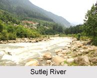
 Sutlej River, an important tributary of the Indus River is the longest of the five rivers of Punjab. It flows through Punjab in northern India as well as Pakistan. It is located north of the Vindhya Range, south of the Hindu Kush segment of the Himalayas and in Pakistan. It originates from the snow filled Lake Rakshastal in Tibet and ends in Pakistani Punjab near the port city of Karachi. Sutlej River is situated at an altitude of 20,000 feet above mean sea level. The Sutlej is the easternmost tributary of Indus River with a total length of 1550 km out of which 529 km is in Pakistan. The Sutlej River is also known as "Satadree".
Course of Sutlej River
River Sutlej takes birth on the southern slopes of the holiest of mountains - Kailash, near the Lake Rakshastal. After a long run, parallel to the Himalayas, it finally penetrates these at Shipki pass. Later it cuts through the Zanskar Himalayan Range, makes a diagonal thrust through the Himalayas and blasts a deep gorge at the base of the Kinnaur Kailash massif. Within Kinnaur district, the Sutlej runs parallel to the Hindustan-Tibet Road. At Karcham, in Kinnaur, it is joined by the crystal clear, blue River Baspa that drains the Sangla valley. After Karcham, the Sutlej turns aggressively, throwing boulders, rocks and rubble around in mighty, foaming rapids.
A rush through Shimla hills and Bilaspur district, and it loses momentum, leaving Himachal Pradesh and entering the plains of Punjab at Bhakra where it mingles with the waters of Gobind Sagar Lake.
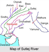 The Sutlej River joins the Beas River in Punjab and then continues in the southwest direction in Pakistan to join the Chenab River.
Important Tributaries of Sutlej River
Spiti River, Baspa River, Soan River and the Nogli Khad are the major tributaries of the Sutlej River.
Hydrology of the Sutlej River
The hydrology of the Sutlej is controlled by spring and summer snowmelt in the Himalayas and by the South Asian monsoon. The rapid course with just the ideal volume of water makes it and its tributaries the "Power House of the Himalayas". The overall hydroelectric power capacity in Himachal Pradesh is evaluated to be 20,000 MW of which around 50% is from the Sutlej valley.
Developmental Projects on Sutlej River
The waters of the Sutlej are allocated to India under the Indus Waters Treaty between India and Pakistan, and are mostly diverted to irrigation canals in India. The river water is mainly used for power generation and irrigation and many large canals draw water from it. There are many hydroelectric and irrigation projects across the river such as the Bhakra-Nangal Dam, Kol Dam, Nathpa Jhakri Project and Baspa Hydel Scheme. There has been a proposal to build a 214 km long heavy freight canal, to be known as the Sutlej-Yamuna Link (SYL), in India to connect the Sutlej and Yamuna rivers.
Sutlej River
An important tributary of the Indus River is the Sutlej River originating from the snow filled Mansarovar Lake in Tibet.


