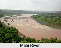
 Mahi River is an Indian River that flows in western India. It is one of the major west flowing inter-state rivers of India. The exact location of the origin of Mahi River is an Indian village called Minda Village, which is situated in Dhar district of Madhya Pradesh. The total length of the river is about 583 kilometers. The drainage area of the river is about 34,842 square kilometers. Mahi River is worshipped by a number of people. It has many temples and places of worship along its shore. The river is popularly described as "Mahisagar" due to its vastness. A district in Gujarat called Mahisagar district, derives its name from the pious Mahi River.
Course of Mahi River
Mahi River originates in the northern slope of the Vindhya Mountain Range in Madhya Pradesh, at an average altitude of about 500m above mean sea level. After its birth, the river flows in the southerly direction of Madhya Pradesh for about 120 km. It enters the south eastern portion of Rajasthan, which is the Vagad region. The river flows through the Banswara district, which comes under the Vagad region. Before entering Gujarat, the river makes a `U` shaped loop in Rajasthan. Finally, the river surrenders itself to the Arabian Sea by a wide estuary near Khambat. The silt brought down by Mahi River has contributed to the thinning of the Gulf of Khambat and the abandonment of its once-rich ports. The riverbed lies considerably lower than the land level and is of little use for irrigation.
 Basin of Mahi River
The Mahi River Basin extends over states of Madhya Pradesh, Rajasthan and Gujarat having total area of 34,842 square kilometers. It is bounded by Aravalli Hills on the north and the north-west, by the Malwa Plateau on the east, on the south by the Vindhyas and the Gulf of Khambat on the west.
Tributaries of Mahi River
Mahi River has many tributaries. The main tributaries of the river are Eru, Nori, Chap, Som, Jakham, Moran, Anas, Panam and Bhadar.
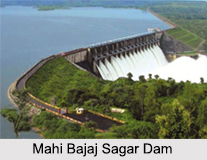
Dams on Mahi River
Mahi River has a dam on it namely, the Mahi Bajaj Sagar Dam. This dam is about 16 kilometers from Banswara town in Banswara district in Rajasthan. The whole of Gujarat gets water to drink and electricity from the dam. The dam is made up of mud with 16 gates in it. It serves as a home to many crocodiles and turtles. Kadana Dam was built in the year 1979 on Mahi River with the purpose of controlling floods in the catchment area as well as to develop better irrigation and hydropower facilities in the area. It is situated in Panchmahals district of Gujarat. Wanakbori Dam located near Wanakbori village has a thermal power station called Wanakbori Thermal Power Station, which uses the water of River Mahi.
Pollution in Mahi River
Mahi River is on the verge of extinction due to pollution and salinity. The bunds constructed to collect water have stopped the surface movement of the river. Consequently, the river is facing an intrusion of saline water from the sea as there is no surface flow to push the seawater back during a low tide. Thus, the groundwater in many areas is becoming saline. Effluents from Indian industries are also adding to the woes of the river. The effluents are accumulating downstream leading to the poisoning of the river.


