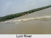
 The Luni River flows in the western part of India in the state of Rajasthan. It rises in the Pushkar valley of the Aravalli Range at an elevation of 550 m. The Luni River begins its course in the Ajmer region and then continues to flow in the peaty areas of Rann of Kutch in the state of Gujarat. The river covers 530 km from Rajasthan to Gujarat state. This river has many names depending upon the place from where it changes its course. The Luni River is also referred as the "Lavanavari River", which means "salt river" in Sanskrit because of its excessive salinity. A seasonal river, it receives much of the drainage of the southwest slopes of the Aravalli Range. The river is highly saline which serves as the primary source of irrigation in the region.
Course of Luni River
Rising on the western slopes of the Aravalli Range near Ajmer, where it is known as the Sagarmati and travels for 530 km. The river then flows in the southwest direction through the hills and across the plains of the Marwar region in Rajasthan. It then enters a patch of desert before it finally disperses into the wastes of the north-eastern part of the marsh called the Rann of Kutch in Gujarat state.
The Basin of Luni River is of 37,363 sq. km with the inclusion of several parts of the Ajmer region from Barmer to Jalore and then moving towards Jodhpur, Nagaur and Pali before its entry into the Sirohi district. Upon reaching Gujarat especially in the northern side of the state, Luni River touches Mithavirana and crosses through the areas like Jordiyali, Mavsari Vav and Radhanpur regions in Banaskantha area.
Tributaries of Luni River
The river and its tributaries flow through the western slopes of the Aravalli Range. The major tributaries of the Luni River are Sukri, Mithri, Bandi, Khari, Jowai, Guhiya and Sagi from the left bank, and the Jojari River from the right bank. Although this river has several tributaries in Rajasthan itself but the notable ones are in the adjacent state of Gujarat.
Present Scenario of Luni River
There are several important developments that have been devoted by this river in the Rajasthan state in terms of using the rivers to its best extent for irrigation and power generation purposes. The construction of Jaswant Sagar in the year of 1892 was being considered a big leap in the regard of this river for making its best use.
The ruler of that time of this region, Maharaja Jaswant Singh of Jodhpur took the initiative to construct a dam on this strategic location of the Pichiyak village located in the midst of Bilara and Bhavi in the Jodhpur District in Rajasthan to ensure that Luni River could be used for best purposes in the region.
Today, this location is being considered for the largest artificial lake in the whole nation. More than 12,000 acres of lands are being irrigated with the water of this river without facing any sort of problem.
Pollution at Luni River
Apart from the irrigation feature by the artificial lake, the Luni River in the town of Balotra, Barmer district, Rajasthan is already dried out. Due to the excessive growth of the textile industries in this town, the rate of intoxication of the river water has highly increased, resulting to the death of the Luni River. An organization has set up a march to spread the awareness of the dying river. Luni has become the most polluted river due to discharge of textile industry effluents.


