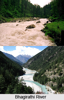
 The Bhagirathi is a tumultuous Himalayan river arising at Goumukh from the snout of the Gangotri glacier at a height of 3,892 meters in Uttarakhand. This river is one of the two main streams of Ganges, the principal river of northern India and the sacred river of Hinduism. According to Hindu mythology and culture, Bhagirathi is the source stream of the Ganges. But according to the hydrology, Alakananda is the source stream of the Ganges for its flow and length.
Myth behind Bhagirathi River
Ganges is considered as the daughter of Bhagiratha. So, she is also called Bhagirathi. According to Hindu mythology, the prince of Sagar Dynasty brought goddess Bhagirathi or Ganga in the form of Ganges River to release his 60,000 great-uncles from the curse of saint Kalipa.
Bhagiratha was the king of an ancient Indian kingdom named Kosala. He was a descendent of the great King Sagara of the Suryavanshi. Bhagiratha was one of the forefathers of Lord Rama, of the Ramayana, the epic in which Bhagiratha`s tale is primarily recounted.
Dams on Bhagirathi River
The names of the 4 dams on Bhagirathi River, in operation, are given below:
Tehri Dam: Bhagirathi River houses the highest dam of India named Tehri Dam. This dam is also considered as one of the tallest dams in the world. It is a multi-purpose rock on the Bhagirathi River near Tehri in Uttarakhand. The Tehri Dam was started by the Tehri Development Project as a major hydroelectric project. It was built with the purpose to have the power generation capacity of 2400 MW, thus catering to the irrigation requirements to an area of 270,000 hectares.
Maneri Dam: The Maneri Dam is a concrete gravity dam on the Bhagirathi River located at Maneri. Maneri is 8.5 kilometres east of Uttarkashi in Uttarkashi district of Uttarakhand. The initial purpose of this dam is to divert water into a tunnel. The tunnel feeds the 90 megawatts Run-of-river hydroelectricity (ROR) Tiloth Power Plant.
Joshiyara (Bhali) Dam: The Dharasu Power Station or Joshiyara Dam is a run-of-the-river hydroelectric power station on the Bhagirathi River. It is located at Dharasu in Uttarkashi district of Uttarakhand.
Koteshwar Dam: The Koteshwar Dam is a gravity dam on the Bhagirathi River. It is located 22 km downstream of the Tehri Dam in Tehri District, Uttarakhand. The dam is a part of the Tehri Hydropower Complex. It serves to regulate the Tehri Dam`s tail race for irrigation and create the lower reservoir of the Tehri Pumped Storage Power Station.
Rafting in Bhagirathi River
Bhagirathi is the favourite place amongst many adventurous people who enjoy river rafting. From Uttarakashi to Devprayag, rafting or kayaking trips are arranged on this river.
Tributaries of Bhagirathi River
Getting formed at Gaumukh at the foot of Gangotri glacier, Bhagirathi is joined by its tributaries Kedar Ganga at Gangotri (elevation 3,049 m), Jadh Ganga at Bhaironghati (elevation 2,650 m), Kakora Gad and Jalandhari Gad near Harsil (elevation 2,745 m), Siyan Gad near Jhala (elevation 2,575 m), Asi Ganga near Uttarkashi (elevation 1,158 m) and Bhilangna River near Old Tehri (elevation 755 m).
From its main source, Bhagirathi River flows 205 km before meeting Alakananda River at Devprayag, where it becomes Ganga or the Ganges River. Ganges is worshiped as Maa Ganga in Hindu mythology.