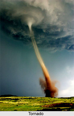
 Tornado is a violent revolving cylinder of air, a few hundred metres across, and about two kilometres in height. This cylinder is rendered visible through the condensation of the moisture present in the air as cloud droplets. Part of the condensation is due to a rapid lifting of the moist air by the vertical currents in the cylinder as in any other cloud, and part through expansion into the low pressure within the revolving cylinder of air. The high speed of rotation, in the range of two hundred kilometres per hour to as much as eight hundred kilometres per hour, is attained through a coming together of slowly revolving air over a wide area. The diameter of this fast-rotating visible cloud varies from two hundred to four hundred metres, but occasionally can be as much as a kilometre. The geographical distance covered by a single tornado during its lifetime of five to ten minutes, is usually three or four kilometres, although on rare occasions it can cover a distance of about a hundred kilometres. The speed of movement of a tornado along its path of destruction is in the range of twenty to eighty kilometres per hour.
Besides the horizontal velocity of rotation and movement along the ground, the air in the revolving cloud has a large vertical velocity also. The air really has an upward spiralling motion. Estimates based on the weight of the objects lifted suggest upward velocities of one hundred to two hundred kilometres per hour. The pressure inside the tornado cloud is very low; it can be as much as thirty percent less than the atmospheric pressure prevailing outside the tornado cloud. This decrease of pressure as the tornado cloud passes over a building has a devastating effect. The outward force exerted by the air inside a building over which a tornado passes can be as much as three tons per square metre of the ceiling and the side wall. It is a suction effect of the tornado. If the tornado grazes one side of a wall, the wall will be pushed sideways into the cloud.
The tornado passes over a particular object or a building in a minute or two. Within this short time, fantastic destruction is inflicted, buildings are destroyed. Individuals and vehicles on its path are lifted up by the vertical currents and left to fall to the ground safely or perched on tree tops or buildings. Trees are uprooted if directly on its path. Tornadoes occur frequently in temperate latitudes, especially over regions where there are no high east-west mountain ranges. They occur very rarely in India of hot weather and then only in the north. The east-west alignment of the Great Himalayan Range acts as a deterrent to the formation of tornadoes in the subcontinent by preventing the inflow of very cold air from the north. A tornado hit the north-west of the Indian state of Assam in the year 1963 which resulted in the killing of one hundred and thirty nine people and made three thousand seven hundred and sixty homeless in thirty three villages. This violent tornado travelled in the southern direction. In the year 1978, at least one hundred and fifty people lost their lives due to a tornado which mainly the villages of Keonjhargarh and Purunabandha in Orissa. In the year 1993 a tornado struck the state of West Bengal in India and in the month of March, 2009 a violent tornado hit the Rajkanika block of Kendrapada district in Orissa state which resulted in severe casualties.