
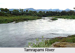
 Thamirabarani River, also known as Tamraparni or Porunai, is
the only perennial river in the Indian state of Tamil Nadu. It
originates from the Agastyarkoodam
peak in the Pothigai Hills of the Western Ghats,
above Papanasam
in the Ambasamudram
taluk of Tirunelveli
district. From its source, the river flows through the districts of
Tirunelveli and Thoothukudi
before emptying into the Gulf
of Mannar. In the pre-classical period, it was known as the Tamraparni
River, a name that was also associated with the island of Sri Lanka.
Historically, the river was referred to as Porunai in ancient Tamil literature
Thamirabarani River, also known as Tamraparni or Porunai, is
the only perennial river in the Indian state of Tamil Nadu. It
originates from the Agastyarkoodam
peak in the Pothigai Hills of the Western Ghats,
above Papanasam
in the Ambasamudram
taluk of Tirunelveli
district. From its source, the river flows through the districts of
Tirunelveli and Thoothukudi
before emptying into the Gulf
of Mannar. In the pre-classical period, it was known as the Tamraparni
River, a name that was also associated with the island of Sri Lanka.
Historically, the river was referred to as Porunai in ancient Tamil literature
Thamirabarani / Tamraparni River
The Thamirabarani or the Tamraparni River is a perennial waterway in Tamil Nadu, known for its ecological richness and cultural significance. Flowing through Tirunelveli and Thoothukudi districts, it supports diverse aquatic life and agriculture. Despite its importance, the river faces environmental pressures that threaten its long-term sustainability and water quality.
Introduction
Etymology of Thamirabarani / Tamraparni River
The Thamirabarani River has been known by several names throughout history, reflecting its long cultural and linguistic heritage. During the Tamilakam era, the river in the Tirunelveli region was originally called Tan Porunai. Over time, its name evolved through forms such as Tamira Porunai, Tamraparni, and Tambraparni before becoming the modern-day Thamirabarani. One widely accepted interpretation of the name derives from the Tamil and Sanskrit word Thamiram, meaning "copper" or "red," and parani, meaning "leaf" or "tree," giving rise to the meaning "river of red leaves" or "copper-colored leaves."
The river's origin is also deeply rooted in mythology.
According to the “Tamraparni Mahatmyam,” an ancient account, describes the
river's journey from its source to its mouth, a garland of red lotus flowers belonging to
the sage Agastya
transformed into a maiden upon beholding Lord Shiva.
This divine maiden then became the river, bestowing upon it the sacred name
Tamraparni. Over the centuries, the river has also been identified by other
names in different languages and traditions, including Tambapanni in Pali,
Tamradvipa in Sanskrit, and Taprobana, the name used by ancient Greek
cartographers.
Historical Reference of Thamirabarani / Tamraparni River
Thamirabarani River has been known by several names over the centuries, including Tampraparani, Tamirabarni, and Tamiravaruni, reflecting its rich historical and linguistic legacy. In ancient Tamil literature, the river is referred to as Tan Porunai Nathi and is mentioned by classical Tamil poets in the Sangam-era work “Purananuru”. Its significance also extends to Sanskrit literature, where it is revered as a sacred river and is referenced in the Puranas, the “Mahabharata,” and the “Ramayana.” During the Early Pandyan Kingdom, the Thamirabarani gained prominence for the flourishing pearl and conch fisheries along its course, as well as the thriving trade that contributed to the region's prosperity.
The movement of people from the Thamirabarani River region
to northwestern Sri Lanka, including pilgrims, merchants, and toddy tappers,
fostered close cultural and economic ties between the two areas. As a result of
these interactions and migrations, the name Tamraparni came to be associated
with the closely connected region in northwestern Sri Lanka.
Course of Thamirabarani / Tamraparni River
Thamirabarani, or the Tamraparni River, originates from the summit of the Pothigai Hills on the eastern slopes of the Western. In its upper course, the river is joined by the headwater tributaries Peyar, Ullar, and Pambar before flowing into the Karaiyar Dam reservoir, where it merges with the Karaiyar River. As it enters the reservoir, the Thamirabarani forms the scenic Paanatheertham Falls, a spectacular waterfall that plunges about 40 metres.
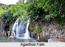 Further downstream, the Servalar River joins the
Thamirabarani before it enters the Papanasam Lower Reservoir supporting the
Papanasam Hydroelectric Station. The river then descends through the rugged
terrain near Papanasam, creating the picturesque Kalyanatheertham Falls and Agasthiar Falls.
Further downstream, the Servalar River joins the
Thamirabarani before it enters the Papanasam Lower Reservoir supporting the
Papanasam Hydroelectric Station. The river then descends through the rugged
terrain near Papanasam, creating the picturesque Kalyanatheertham Falls and Agasthiar Falls.
After descending from the hills near Papanasam, the Thamirabarani River flows eastward across the fertile plains of southern Tamil Nadu. The first major tributary to join the river in the plains is the Manimuthar River, followed by the Gadananathi River at Tiruppudaimaruthur. Further downstream, the Pachaiyar River, which originates in the Kalakkadu Reserve Forests, merges with the Thamirabarani near Tharuvai village in Palayamkottai Taluk.
Continuing its course, the river flows between the twin cities of Tirunelveli and Palayamkottai before being joined by its largest and most significant tributary, the Chithar River. Rising in the Kutralam Hills, the Chithar is fed by several rivers, including the Gundar, Hanumanathi, and Karuppanathi. The Thamirabarani then continues its journey through the taluks of Tirunelveli and Palayamkottai in Tirunelveli district, as well as Srivaikundam and Tiruchendur in Thoothukudi district, before eventually making its way toward the Gulf of Mannar.
The Thamirabarani River empties into the Gulf of Mannar near Punnaikayal in Tiruchendur Taluk of Thoothukudi district. With much of its extensive catchment area located in the Western Ghats, the river benefits from both the southwest and northeast monsoons, making it the only perennial river in Tamil Nadu. All of its major tributaries also originate in the Western Ghats, ensuring a steady flow throughout the year. However, this dependence on monsoon-fed tributaries also makes the river highly susceptible to flooding, particularly during the northeast monsoon season, when heavy rainfall significantly increases its discharge.
Biodiversity of Thamirabarani / Tamraparni River
The Thamirabarani or the Tamraparni River, is renowned for its rich aquatic biodiversity and is considered one of the most fish-diverse rivers in India. Its perennial flow provides a stable freshwater habitat throughout the year, supporting a wide variety of native fish species. Local communities generally refrain from indiscriminate fishing in many stretches of the river, a practice that has helped preserve its remarkable aquatic ecosystem.
Among the river's most abundant inhabitants are native snakehead fishes, with more than 16 species recorded. Catfish are also found in large numbers, while carp species occur throughout the river's course. Eels belonging primarily to the families Anguillidae and Synbranchiformes are common, with the Indian mottled eel being among the most frequently encountered species. Numerous species of sucker fishes also inhabit the river, contributing to its diverse freshwater fauna.
The Thamirabarani is home to a wide range of other fish genera, including Puntius, Devario, Etroplus, Mystus, Aplocheilus, Dawkinsia, Garra, Glossogobius, Macrognathus, Batasio, Barilius, Badis, Clupisoma, Nemacheilus, Oreichthys, Oryzias, Osteobrama, Raiamas, Salmophasia, Tor, and Xenentodon, highlighting the river's exceptional ecological diversity.
Although not native to the Thamirabarani, the Alligator Gar has occasionally been reported in the river. These sightings are believed to have resulted from aquarium fish being released into the wild. In 2015, more than 100 juvenile Alligator Gar were captured from the river and handed over to the local authorities, drawing attention to the ecological risks posed by the introduction of non-native species into natural freshwater ecosystems.
Irrigation Facilities on Thamirabarani / Tamraparni River
The Thamirabarani River supports an extensive network of anicuts, dams, and reservoirs that play a vital role in providing irrigation and generating hydroelectric power for the Tirunelveli district. Numerous irrigation channels branch out from both banks of the river, distributing water to vast agricultural lands across the region. Major channels include the South Kodaimelalagian Channel, North Kodaimelalagian Channel, Nathiyunni Channel, Kannadian Channel, Kodagan Channel, Palayam Channel, Tirunelveli Channel, Marudur Melakkal, Marudur Keelakkal, and the South and North Main Channels.
These channels are supplied through a series of anicuts,
including the Kodaimelalagian, Nathiyunni, Kannadian, Ariyanayagipuram,
Palavur, Suthamalli, Marudur, and Srivaikundam anicuts. The first seven anicuts
were constructed during the reign of ancient and medieval rulers, reflecting
the region's long-standing tradition of water management. The Srivaikundam
Anicut, the last in the series, was built by the British and completed in 1869,
further strengthening the river's irrigation network and enhancing agricultural
productivity in the region.
Environmental Challenges Affecting Thamirabarani / Tamraparni River
Despite various conservation and development projects, the Thamirabarani (Tamraparni) River continues to face significant environmental challenges that threaten its water quality and long-term sustainability. Issues such as illegal sand mining, industrial effluent discharge, untreated sewage inflow, and encroachments along the riverbanks have placed considerable pressure on the river’s ecosystem.
In and around Srivaikuntam, several industries established
along the river have been reported to use river water indiscriminately while
releasing untreated wastewater back into it. In addition, untreated sewage from
towns such as Ambasamudram, Tirunelveli, and Papanasam further degrades water
quality as it flows downstream, compounding the environmental stress on the
river system.
Recently updated articles in Geography of India

Krishnaveni River
The Krishnaveni River, presently known as the Krishna River, is one of India’s major rivers. Originating in the Western Ghats of Maharashtra, it flows...

Wakal River
The Wakal River is an important tributary of the Sabarmati River, originating in Rajasthan’s Aravalli Range and flowing through Rajasthan and Gujarat....

Pahuj River
Pahuj River is an important tributary of the Sindh River that flows through the Indian states of Madhya Pradesh and Uttar Pradesh. Originating in the...

Arunavati River
Arunavati River is a seasonal right-bank tributary of the Tapi River, flowing through parts of Madhya Pradesh and Maharashtra. Originating in the Satp...

Nira River
Nira River is an important tributary of the Bhima River flowing through Maharashtra. Originating in the Western Ghats, it traverses Pune, Satara, and...
Related articles in Geography of India

Geography of Sikkim
Geography of Sikkim is characterised by a vast array of magnificent hillock that extends from one corner of the state to the other.

Geography of Meghalaya
The suitable climate, highland plateaus, rivers and the flora and fauna together forms the geography of Meghalaya.

Geography of Jammu & Kashmir
Jammu and Kashmir is encompassed by valleys. Some of the dominant valleys of the state are Kashmir Valley, Tawi Valley, Chenab Valley, Poonch Valley,...

Narmada River
Narmada River is regarded as the 5th longest river of India and the life line of Madhya Pradesh. Narmada River basin spreads over an area of about 98,...

Bhima River
The Bhima River is the largest tributary of the Krishna River and is significant in the western and southern Indian states.