Introduction
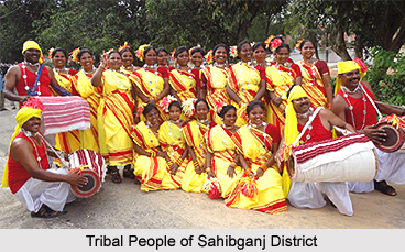
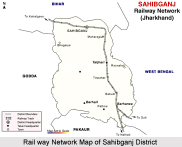 Sahibganj District in Jharkhand with a predominantly tribal population is a part of Santhal Pargana division and forms the eastern most tip of the division. This administrative district of Jharkhand has its headquarters at Sahibganj. Rajmahal District and Pakur District subdivisions of old Santhal Pargana district were carved out on 17th of May, 1983 to form Sahibganj District. Subsequently, Pakur sub-division of Sahibganj District was carved out on 28th January, 1994 to constitute Pakur District. Administration of Sahibganj District has two sub-divisions and nine administrative blocks and these are Sahibganj, Mandro, Borio, Barhait, Taljhari, Rajmahal, Udhwa, Pathna and Barharwa. The total number of villages in Sahibganj District is 1819. Of these, 1307 are inhabited and 512 uninhabited. There are 166 Village Panchayats.
Location of Sahibganj District
Sahibganj District lies approximately between 24 degree 42 minutes north and 25 degree 21 minutes north latitude and between 87 degree 25 minutes and 87 degree 54 minutes east longitude. Sahibganj, the administrative headquarter of the district is situated on the bank of Ganga River at 25 degree 15 minutes north latitude and 87 degree 38 minutes east longitude. The geographical area of the district is 1599 sq km. Sahibganj District is bounded by river Ganga and Katihar District in its north, by Godda District in its south, by Malda District and Murshidabad District of West Bengal in the east, and by Bhagalpur District and Godda district in the west.
History of Sahibganj District
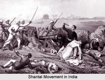 History of Sahibganj District in Jharkhand is rich and interesting. It revolves mainly around the history of Rajmahal, Teliagarhi Fort and Sahibganj Town itself. The history of Sahibganj District is inseparable from the history of its parent district of Santhal Pargana with its headquarters at Dumka and is interrelated with the histories of Godda District, Dumka District, Deoghar District and Pakur District. As a direct consequence of the Santhal Rebellion of 1854-55, Santhal Pargana has been created as a separate district in 1855 by ceding portions of Bhagalpur and Birbhum District.
The early history of Sahibganj District gives evidences that the area is inhabited since time immemorial by Mal Paharia Tribe. Medieval history of Sahibganj District states that on 12th of July 1576, the battle of Rajmahal was fought and the foundation of the Mughal rule in Bengal was laid. It was Man Singh, general of Akbar, who made Rajmahal the capital of Bengal in 1592. But this honour of Rajmahal was short-lived, as the capital was shifted to Dacca in 1608. In 1639, Rajmahal regained its glory and was made the capital of Bengal by Shah Shuja, second son of Emperor Shah Jahan, on his appointment as the Viceroy of Bengal. It continued as the seat of the Mughal Viceroy up to 1660.
After the victory at the Battle of Plassey, Bengal which contained the present Sahibganj District was captured by the rulers of British East India Company. In Santhal Pargana, they were opposed by the Paharias. Santhals settled in the district after migrating from Birbhum District, Bankura District, Hazaribagh District and Rohtas within 1790 to 1810. The Santhals became an easy prey to the unscrupulous hill-men and non-Santhal traders. They were exploited them to the maximum. These entire facts and circumstances led to the Santhal Rebellion of 1855. The object of the Santhal uprising was the economic liberation of the Santhals. The first spark of the revolt was ignited at Littipara. The Santhal rebellion was the predecessor of the first Indian Freedom Movement of 1857. Sahibganj province was not immune from patriotic fervor, and played its role in the country`s struggle for freedom from 1921 onwards. The district played its role in the Salt Satyagraha Movement and the Civil Disobedience Movement of 1930. The movement gathered momentum and the British Government had to send military forces to control the situation.
History of Sahibganj District also states that after the independence of the country, government considered the Paharias and other tribal groups of Rajmahal hills as demographically underdeveloped section of the society. So, new policies and plans for their emancipation were planned. The Jharkhand Movement for more empowerment spearheaded by tribal communities and demand for separate statehood thus gained momentum and finally on 15th November 2000, a separate state named as Jharkhand came into existence comprising 18 districts of the Chota Nagpur Plateau and Santhal Pargana divisions.
Geography of Sahibganj District
 Geography of Sahibganj District includes vast hilly terrains. The vast tract of land enclosed between hill ranges is described with a Persian word `Damin-I-koh` that means `skirts of the hills.` In Sahibganj District, the land on the bank of Ganga River is prolific and richly cultivated. Owing to large scale unscrupulous felling the region once known for its thick and extensive forests is now bereft of much of its forest wealth.
Sahibganj District may be divided into two natural divisions on the basis of its geographical location and cultivable land. First region consists of Borio, Mandro, Barhait, Pathna and Taljhari blocks and lies under Damin-I-koh area. The hills and slopes are covered with forests. The valleys have cultivable lands, yielding mostly paddy. The inhabitants of this region are generally Paharia Tribe, Mal Paharia Tribe and Santhal Tribe. The inhabitants on the hill top cultivate maize by using rain water. The second region consists of Sahibganj District, Rajmahal Hills, Udhwa and Barharwa blocks. This plain region consists of the uplands, undulation along ridges and depressions. The Ganges, Gumani and Bansloi rivers flow through this region. This area has plenty of fertile lands and is highly cultivable.
Ganga River forms the northern boundary of Sahibganj District enters at its north western corner and passes eastward and takes a southward turn forming the southern boundary of the district. Its average width is near about 4 and half kms. It generally swells during the rains and inundates the lowlands lying east of the Railway loop line. There are ferry services across the river between Sahibganj ghat in Sahibganj district on this side and Manihari ghat in Katihar district. Gumani River emerges from the southern region of the Rajmahal hills. It flows in a north-easterly direction up to Barhait valley where it is joined by Mural River. The joint stream takes a south-eastern turn and joins the Ganges a little beyond the district boundary.
Rajmahal Hills are the source of building and road stones. Most of the quarrying is done by the side of the loop line of the Eastern Railway. Pakur chips are quite well known and are used extensively all over Jharkhand, Bihar and parts of West Bengal. The traditional cottage and village industries practiced by the Santhal Tribe and the Paharia Tribe include tasar rearing, carpentry, handloom weaving, rope making, earthen ware making, stone ware making, etc. However, there is no large-scale industry available in the area mainly due to lack of infrastructure support. A number of small-scale industries have been set up in the district. Most of these are based on mining activities. Sahibganj is one of the most important places for trade and commerce in the district. The main imports of the district are linseed, mustard seed, raw cotton, sugar, refined and unrefined molasses, salt, kerosene oil, coal, coke, gunny bags, gram, wheat and maize. The main exports are paddy, jowar, grass, stone chips, hides and fibers.
Demography of Sahibganj District
According to the Population Census in the year 2011, Sahibganj District had a population of 1,150,038 of which male and female were 590,390 and 559,648 respectively. The population of Sahibganj District constituted 3.49 percent of total population of the Sahibganj District.
The population density of Sahibganj district is 719 people per sq. km. Sahibganj district administers 1,601 square kilometers of areas. The average literacy rate of Sahibganj District in 2011 was 53.73 percent. If things are looked out at gender wise, male and female literacy were 62.65 and 44.31 respectively. The total literates in Sahibganj District were 501,643 of which male and female were 300,522 and 201,146 respectively.
Tourism in Sahibganj District
 Tourism in Sahibganj District comprises visits to various places of religious, historical and archaeological importance. These places of interest attract people from different parts of the country. There is no dearth of tourism spots in this district of Jharkhand. Tourism in Sahibganj District means a pleasurable tranquil experience for the travellers visiting this district.
Rajmahal: Situated on the right bank of Ganga River, Rajmahal is a small but historically important town. It was the seat of the government during the Mughal Dynasty period, when Raja Man Singh, general of Emperor Akbar made Rajmahal the capital of Bengal in 1592. Even today relics of the old and prosperous Rajmahal can be found. The town has several important monuments like Singhi Dalan, Akbari Masjid, Tomb of Maina-Bibi and Tomb of Miran.
Mangalhat: Situated 10 kilometers west of Rajmahal, it is the site of an important monument Jama Masjid which was built during the reign of Emperor Akbar.
Kanhaiyasthan: Situated on the bank of river Ganga is a village situated about 13 km north-west of Rajmahal town and owes its name to the temple of Lord Krishna. Footsteps of Chaitanya are also preserved here.
Sahibganj: It is situated on the southern bank of the Ganges in the north-eastern region of Rajmahal subdivision. Sahibganj is the sub-divisional headquarters since 1944 and presently it is the district headquarters as well. The town has a well, constructed in 1915 known locally as "Bhagwa Kuan" which was constructed in memory of Edward VII.
 Teliagarhi: These are remains of an old fort known as Teliagarhi and it is located near Karamtola station.
Shivgadi: This Shiva temple is located in the Barhait block 8 kms north of Barhait and is inside the cave. Devotees gather here on the occasion of Mahashivratri.
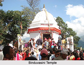
Binduvasini Temple: It is situated 2 kms away from Barharwa railway station. Devotees gather in large number on Ramnavami at this temple during the fair which lasts for nine continuous days.
Raksisthan: Situated in Mandro block near the Karamtola railway station just west of the Teliagarhi fort, this temple is considered very religious by the people.
Bhoganadih and Panchkathiya: The village of Sido and Kanu, the legendary brothers who led the Santhal revolt in 1855, is considered as sacred by the tribal people.
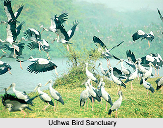
Udhwa Bird Sanctuary: The only bird sanctuary in the entire state of Jharkhand is situated near Udhwa; locally called Patauda Lake. Hundreds of migratory birds come here every winter.
Moti Jharna: It is near Maharajpur popularly known for its natural beauty.
Maghi Mela: Organized on every full moon of Magha at Rajmahal, this fair has an important place in the tribal life.
These tourist attractions will surely leave the travellers with a memorable experience.