 Dumka District is an administrative district of Jharkhand with its headquarters at Dumka. Dumka District is located at 86 degree 16 minutes north latitude and 87 degree 15 minutes east longitude. This district of Jharkhand is situated at the height of 472 feet from the sea level. The district has an area of 3716 sq km and consists of only one sub division namely Dumka. Under Dumka sub division, there are 10 blocks namely Dumka, Gopikander, Jama, Jarmundi, Kathikund, Maslia, Ramgarh, Raneshwar, Shikaripara and Saraiyahat. Dumka District is enjoying the status of sub-capital of Jharkhand since 2000.
History of Dumka District
History of Dumka District is categorized into Stone Age, early history, medieval period and British period. On the basis of tools unearthed the original inhabitants of this region appear to be the Mon-khmers and the Munda tribe. Further, according to historical accounts, it appears that the Paharia Tribe (Maler and Sauria Paharias) inhabited the district. Due to inaccessibility of the area caused by the cliffs of Rajmahal Hill it was a place of strategic economic importance with a fort at Teliagarhi. After 1539 victory of Shershah Suri at Chousa, the area was occupied by the Afgans and then by the Mughal Emperors.
Between 1742 and 1751 the area of Dumka close to Rajmahal witnessed frequent inroads of the Marathas under Raghoji Bhonsle and Peshwa Balaji Rao. In 1745, Raghoji Bhonsle entered Rajmahal via hills and jungles of Santal Pargana. In 1775, it was transferred to Bhagalpur Division. It was in the year 1865 that Dumka was made an independent district after being carved out of Bhagalpur. In 1872, Dumka was made headquarter of Dumka District of Santal Pargana.
Geography of Dumka District
Dumka District has predominantly undulating terrain with hard rocks in the underground. Entire district has topography with high ridges and valleys bounded by mountains and rivers. The fertility of soil is poor due to extensive erosion, acidic character and low retaining capacity. Dumka District is situated in an idyllic surrounding of hill ranges, rivers and forests. Topographically this district is an upland tract with a hilly backbone running from north to south. Ramgarh Hills (South East of Dumka), Lagwa Hills (near Nonihat), parallel running hill ranges from Masanjore to Ranibahal. Moreover, geography of Dumka District includes several scattered hillocks that add a fascinating charm to the beauty of the district. To add more to the natural charm of the scenery several river system like that of the Mayurakshi River, Ajay River and many more rivers enhance the beauty of Dumka District. They are also a major source of irrigation.
Demography of Dumka District
According to the Populaton Census in the year 2011, Dumka District had population of 1,321,096 of which male and female were 669,240 and 651,856 respectively. The population of Dumka District constituted 4.01 percent of total population of Jharlkand. The population density of Dumka district for 2011 is 300 people per sq. km. The average literacy rate of Dumka District in 2011 was 62.54 percent. If things are looked out at gender wise, male and female literacy were 75.17 and 49.60 respectively. The total literates in Dumka District were 693,058 of which male and female were 421,293 and 271,674 respectively. With regards to Sex Ratio in Dumka District with its headquarters in Dumka, it stood at 974 per 1000 male compared to 2001 census figure of 962. The average national sex ratio in India is 940. In 2011 population census, the child sex ratio is 957 girls per 1000 boys compared to figure of 975 girls per 1000 boys of 2001 census data.
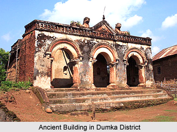
Tourism in Dumka District
There is no dearth of attractive tourism options in Dumka District. This district of Jharkhand offers several religious and nature tourism options. Baba Basukinath Dham, Baba Sumeshwarnath, Naag Mandir, Malooti, Mayurakshi River, Masanjore Dam, Tatloi, Water Park and Shristi Hill Park are the major attractions of Dumka District that are worth visiting.
Dumka District
Dumka District of Jharkhand has its headquarters at Dumka. This district occupies an area of 3716 sq kms. Geographical features of Dumka District include forests, rivers and hill ranges.


