
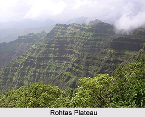
 Rohtas Plateau or known as Kaimur Plateau is series of fluvial plateaux that run along the Kaimur Range consist of a series of descending plateaux, starting with the Panna Plateau in the west, followed by Bhander Plateau and Rewa Plateau and ending with Rohtas plateau in the east.
Rohtas Plateau or Kaimur Plateau comprises about 800 square miles of sedimentary rocks. It is an undulating tableland. At Rohtasgarh fort, it attains a height of 1,490 feet (450 m) above sea level. There are torrential hill waterfalls have cut deep gorges at the borders of the plateau. These waterfalls add the scenic beauty of the area. People from all parts of India throng in this area for picnic and for the weather change.
Rising abruptly from the plains the sides of the Rohtas Plateau, it presents a sight of a sharp escarpment. The roof of the Kaimur Plateau tableland at the top is full of small saucer shaped valleys. The rivers of the Kaimur Plateau flowing over the edges of the plateau and into the deep gorges form numerous waterfalls, with a drop varying from two hundred to six hundred feet.
The road approaches to the Rohtas Plateau from the plains are difficult. The ghats leading from Akbarpur to Rohtas are the most moderate. There are other tolerable ascents at Sarki near the south-western boundary, at Kariyari Khoh in the deep gorge north of Rohtas, at Ghoraghat, two miles south of Sasaram, and on the extreme west where a ghat leads up to Chhanpathar.
There are many waterfalls along the plateaux lining the Kaimur Range and the Rhotas Plateau ranging the height between 15m and 180m are found along this fault line. Some of the significant waterfalls along Rohtas Plateau that add the beauty and attract the tourists are Devdari Falls, Telharkund Falls, Suara Falls, Durgawaati Falls, Okharean Kund Falls, Dhuan Kund Falls, Kuaridah Falls and Rakim Kund Falls.
This article is a stub. You can enrich by adding more information to it. Send your Write Up to content@indianetzone.com









