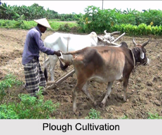
 Plough Cultivation is practiced in various states of North East India. The economy of North East India is agro-based. Above 80 percent of the total population of the region depend on agriculture. Yet, the method of agriculture is still traditional in nature all over the North East India. Rice is the staple food. In the plains of the region, i.e., in Assam and in some plain river valleys of other states, it is carried out by Plough cultivation with traditional techniques. In the method of Plough cultivation, the farmers harvest crops in such a way that it improves the fertility of the soil. This farming practice develops a balance between preserving natural resources and protecting the environment for the needs of the future generations. This is the original method of farming that has been practiced by traditional farmers from generation to generation.
 Season for Plough Cultivation
In Plough cultivation, paddy is grown two times a year. First, in the month of February/ March and is harvested during June and July. It is called "Ahu" in Assamese. The next one is planted in the month of August and harvested in the month of November/ December. It is known as "Sali". Some high yielding varieties too are planted now-a-days. For the Ahu, the rice-field is prepared with the help of hoe and plough. Since it is done during dry season, i.e., in February/ March, the field remains dry.
Process of Plough Cultivation
The soil is crushed well before seeds are sown. As they grow proper irrigation is done. The crop matures in the month of June/ July. After harvesting the Ahu, Sali rice is planted. During this time, North East India gets enough rainfall from the monsoon and the Sali cultivation becomes a wet cultivation. Seeds are sown thickly a month before the transplantation. For high productivity, cow dung and chemical fertilizers are used. Harvesting takes place in the month of November/ December.
Production in Plough Cultivation
Plough Cultivation is also used in Ravi Crops. Among the Ravi crops, various oilseeds, vegetables, potatoes, chillies etc., are worth mentioning. In the changing situation, people have started to use some advanced agricultural implements, still the practice is known as Plough Cultivation.