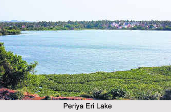
 Periya Eri Lake meaning big lake is located in the outskirts of Chennai in the Indian state of Tamil Nadu. The lake is also known as "Pallavaram Lake" and is situated on the railway track extending from Pallavaram to Chromepet on the eastern side. Earlier it was a huge lake and the railway trains as well as the tracks could be seen even from the banks of the Periya Eri Lake. However, due to encroachments and construction works the lake shrunk with time. The waste waters of the leather companies located nearby mingles with the lake. A burial ground can be seen on the south eastern side of the lake. The last rites are performed here and the ashes are immersed in the lake. Thus the lake has become a dump yard and its water has become polluted.
Present Condition of the Lake
The Pallavaram Lake was once a sprawling water body covering about 189 acres. Today it has shrunk and looks like a big pond. Today, all that remains of it is a small patch on the lines of a pond on one side and a hillock of garbage on the other and this is one issue for which more than one government department should be held accountable.
Reasons for Pollution on the Periya Eri Lake
•The dumping of garbage from all the 42 wards of the Pallavaram Municipality for nearly a decade is the main reason for the water body hanging by a thread. Residents of the locality blame State government agencies for having done nothing at all to prevent the rot from spreading.
•The lake"s health was altered by waste waters from Chrome leather companies situated on western side mixes in the lake.
•The lake has shrunk due to huge violation and illegal buildings and constructions that took place over the decade.
In the year 2001 a part of the lake on the eastern side was razed in order to drain out water for building roads. The construction of Pallavaram - Thoraipakkam Road, a project initiated to connect Chennai Airport and Rajiv Gandhi Salai, had split the lake into two halves. The portion of the lake to southern side of the road has completely been covered by garbage.
On the northern side of the road, the discharge of sewage from commercial establishments and homes and also effluents from some of the leather manufacturing units in Nagalakeni has affected the water.
There is acute water shortage in Chennai city despite the presence of so many lakes. Presently, the lake is spread over a small acre of land on one side and on the other side the lake does not have a single a drop of water and has turned into a dump yard with huge garbage piles. There are over 3,000 lakes and ponds in the Chennai metropolitan area. If it they are desilted, deepened and maintained, it would be enough to meet Chennai"s water needs.
Periya Eri Lake
Periya Eri Lake also known as Pallavaram Lake is located in Chennai in Tamil Nadu. A burial ground is also located here.


