
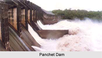
 Panchet Dam is located across Damodar River at Panchet in Dhanbad district of Jharkhand</b>. It was the last of the four multi-purpose dams included in the first phase of the Damodar Valley Corporation. Damodar River forms the border between Dhanbad district of Jharkhand and Purulia district of West Bengal, before meeting the Barakar at Dishergarh and flowing fully through West Bengal. Panchet Dam has been constructed a little above its confluence with the Barakar. Dhanbad district is on the northern bank and Purulia district is on the southern bank of Panchet reservoir. Panchet Hill rises above Panchet Dam. It is known to be one of the most important hydel power stations, with a generating capacity of 40 MV power. This dam is eventually becoming a place of tourist attraction.
History of Panchet Dam
As a result of 1943 destructive flood incident, Government of India appointed Damodar Flood enquiry to look upon the matters. So, Damodar Valley Corporation came into existence in the year 1948 for the management of this entire matter. It was first decided that eight dams and a barrage would be constructed, but later four dams at Tilaiya, Konar, Maithon and Panchet and Durgapur Barrage were constructed.
Details of Panchet Dam
Panchet Dam is 22,155 ft long and 134 ft high. It is an earthen dam with concrete spillway. The reservoir taps a catchment area of 10,961 sq. km. Two units of 40 MW have been installed for power generation.
Impacts of Panchet Dam
Panchet dam constructed in 1959 has significantly reduced daily and annual discharge also largely eliminating the extremes of flow so that ten-year recurrence interval floods would be reduced to half. Sediment trapping in reservoirs and the lack of flushing due to reduced peak discharge have inevitably transformed the lower Damodar basin into an ecologically imbalanced area.
Visiting Information to Panchet Dam
Kumardubi Railway Station lies almost 10 km away from Panchet Dam and is the nearest railhead of it. Bus services are also available from Barakar, Maithon, Asansol and Dhanbad (50 km) to reach the Panchet Dam. Panchet Dam is located near National Highway 2.









