Introduction
 There are various thoughts regarding the derivation of the name `Kasaragod`. According to one view it is the combination of two Sanskrit words "kaasaara", which means lake or pond and "kroda" that means a place where treasure is kept. Another view expresses that it is the place where Kaasaraka trees or Strychnos nux vomica or Kaanjiram or Kaaraskara are in abundance. But it can be seen that in both the there are large number of rivers, lakes and ponds in the coastal belt of the district. Besides which there is thick flora consisting of innumerable varieties of trees, shrubs etc. Particularly plenty of Kaasaraka trees are present in this locality.
History of Kasaragod district
 From a very ancient time the kasaragod district was famous. It lies on the northwestern coast of the State. Many Arab travelers who came to Kerala between 9th and 14th centuries A.D. invariably visited Kasargod. It was the then important trade center. They called this area Harkwillia. In 1514 Mr.Barbose the Portuguese traveler visited Kumbla near Kasargod.
According to him rice was exported to Male Island whence coir was imported. Dr.Fracis Buccanan, who was the family doctor of Lord Wellesly, visited Kasargod in 1800. In his travelogue, he has included information on the political and communal set-up in places like Athiparamba, Kavvai, Nileshwar, Bekkal, Chandragiri and Manjeshwar. Kasargod was part of the Kumbala Kingdom in which there were 64 Tulu and Malayalam villages.
At the time of attack of Kasargod by Vijayanagar Empire, the district was ruled by the Kolathiri king.who had Nileswar as his headquarters. It is said that the characters appearing in Theyyam, the ritualistic folk dance of northern Kerala, represent those who had helped king Kolathiri fight against the attack of the Vijayanagar Empire.
In 14th century when the empire declined, the administration of this area was vested with the Ikkeri Naikans. They continued to be the rulers till the fall of the Vijayanagar Empire in 16th century. Then Vengappa Naik declared independence to Ikkeri.
In 1645 Sivappa Naik took the reins and transferred the capital to Bednoor. Thus they came to be known as Bendoor Naiks. Chandragiri fort and Bekkal fort are considered to be part of a chain of forts constructed by Sivappa Naik for the defense of the kingdom.
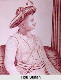
In 1763 Hyder Ali of Mysore conquered Bednoor with an intention to capture entire Kerala. But after his attempt to conquer Thalassery Fort was obstructed, Hyder Ali returned to Mysore and died there in 1782. After him his son, Tipu Sultan, continued the attack and conquered Malabar. But according to the Sreerangapattanam treaty of 1792, Tipu surrendered Malabar except Tulunadu or Canara to the British.
The British got Canara only after the death of Tippu Sulthan in 1799. Kasaragod was part of Bekal taluk in the South Canara district of Bombay presidency. Kasaragod taluk came into being when Bekal taluk was included in the Madras presidency on April 16, 1882. Though Vengayil Kunhiraman Nayanar moved a resolution in 1913 on the floor of Madras Governor`s Council demanding the merger of Kasargod taluk with the Malabar district, it had to be withdrawn because of the stiff opposition of the members from Karnataka. In 1927,a political convention held at Kozhikode, passed a resolution stressing the above demand.
An organization titled Malayalee Seva Sangham was constituted in the same year. Many eminent persons like K.P.Keshva Menon, Kasargod became part of Kerala following the reorganisation of states and formation of Kerala in November 1,1956.
Kasargod played a prominent role in the National Movement for the freedom of the country. Mohammed Sherul Sahib and Kandige Krishna Bhat were the frontline leaders of the independence movement. Some of the prominent freedom fighters of our independence movement were from this district namely Umesh Rao, K.M.Krishnan Nambiar, Shreesankarji, Naranthatta Raman Nair, A.C.Kannan Nair, T.Gopalan Nair, and Meloth Narayanan Nambair.
The agrarian struggles to end the exploitation and oppression by landlords and leaders were part of the National Movement. The Kadakom Sathyagraha various struggles unleashed for the uplift of the scheduled castes and tribes also supported and enlivened in National Movement.
Climate
Temperature:
The district has a diversity of the physical features, which results into a corresponding diversity of climate.
The climate of the district can be classified as warm, humid and tropical. Where the average maximum temperature is 31.2oC and minimum is 23.6oC. Though the mean maximum temperature is only around 90oF,
the heat is oppressive in the moisture-loaded atmosphere of the plains. Humidity is very high and rises to about 90 percent during the southwest monsoon. The annual variation of temperature is small, the periodic range is only about 10oF.
Rainy Season:
The mean annual rainfall of the district can be said as 3581mm. This is regarded as highest in the state while the state average is 3063mm. The southwest monsoon starts towards the end of May or the beginning of June. This continues with the thunderstorm and hold till September when the monsoon fades out. The northeast monsoon can be brought by October-November. Out of the total rainfall specifically the months of June, July and August experiences 2/3 of the quantity. Dry weather in this district lasts from December to February. Where March to May is the hot season. The coolest months of the year are January-February.
Demography of Kasaragod District
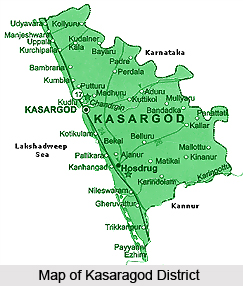
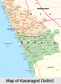
The total geographical area in the district is about 1992 sq. km. There are two taluks namely Kasargod and Hosdurg present in the district. There are all total 75 numbers of revenue villages and two municipalities present in the district. The municipalities are present in Kosaragod and Kanhangad. There are different blocks as well as 39 numbers of panchayats. There are 234 post offices and telephone exchange and T.V. stations are also there.
According to 2001 Census the total population of the district is 12,03,342. Out of which 5,87,763 are males and 6,15,579 are females. The density per sq. km is 604. Sex ratio per 1000 males is 1047.
According to 2001 Census the total population of the district is 12,03,342. Out of which 5,87,763 are males and 6,15,579 are females. The density per sq. km is 604. Sex ratio per 1000 males is 1047.
Geography of Kasaragod District
The district is marked off from the adjoining areas outside the State by the Western Ghats. The Western Ghats run parallel to the sea and constitute an almost continuous mountain wall on the eastern side. The Ghats dominate the topography of the district. The coastline is surrounded with low cliffs alternating with stretches of sand. A few miles to the interior, the scene changes and the sand level rises towards the barrier of the Ghats. This also transforms into low red laterite hills placed with paddy fields and coconut gardens.
The district falls into three natural division based on physical features, these can be named as The low land, which borders the sea, the mid land consisting of the undulating country and the forest, and the clad high land on the extreme east. There are mainly four types of soils present in the district namely, sandy, sand loam, laterite and hill or forest soil. The sandy and the sandy loam soils exist as a continuous narrow belt all along the Western coast about 20 Km in width.
The land of the district can be categorized in detail as follows.
• Steeply slopy hill lands,
• Upland plateau,
•Deep gorges with steep side slopper and very narrow valleys.
•Border valleys bounded by subdued hills,
•Coastal plain and marine plain
• Nearly level lowland plains along the coastal plain.
Rivers:
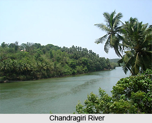
There are 12 rivers in this district. Out of which the longest is Chandragiri whose length is 105 km originating from Pattimala in Coorg. It embraces the sea at Thalangara, near Kasargod. It is assumed that the name of the river Chandragiri has taken from the name of the place of its source Chandragupta Vasti. This is the place where the great Maurya emperor Chandragupta is believed to have spent his last days as a sage.
The second longest river is Kariankod, which is 64 km in length. Across this river there is a dam, which is being built at Kakkadavu. The name of some of the other rivers and their lengths are given below: Shiriya is 61 km in length, Uppala is 50 km lengthy, Mogral is 34 km in length, Chithari is 25 km lengthy, Nileshwar (47 kms), Kavvayi (23 kms), Manjeswar (16 kms), Kumbala (11 kms), Bekal (11 kms) and Kalanad (8 kms).
These rivers provide ample irrigation facilities in the district.
Reserve forests:
Adoor, Eleri, Karudukka, Maloth, Parappa, Panathady and Muliyar are some of the reserve forests in the district. These forest areas have different types of medicinal plants and shrubs as well.
Mangrove forests (kandal kadukal):
In earlier days the river-sea joining lands were abundant with these forests. But now they are seen only in Chittari, Manjeshwar, Mogral, Uppala, Shiriya rivers.
The district falls into three natural division based on physical features, these can be named as The low land, which borders the sea, the mid land consisting of the undulating country and the forest, and the clad high land on the extreme east. There are mainly four types of soils present in the district namely, sandy, sand loam, laterite and hill or forest soil. The sandy and the sandy loam soils exist as a continuous narrow belt all along the Western coast about 20 Km in width.
The land of the district can be categorized in detail as follows.
• Steeply slopy hill lands,
• Upland plateau,
•Deep gorges with steep side slopper and very narrow valleys.
•Border valleys bounded by subdued hills,
•Coastal plain and marine plain
• Nearly level lowland plains along the coastal plain.
Rivers:
There are 12 rivers in this district. Out of which the longest is Chandragiri whose length is 105 km originating from Pattimala in Coorg. It embraces the sea at Thalangara, near Kasargod. It is assumed that the name of the river Chandragiri has taken from the name of the place of its source Chandragupta Vasti. This is the place where the great Maurya emperor Chandragupta is believed to have spent his last days as a sage.
The second longest river is Kariankod, which is 64 km in length. Across this river there is a dam, which is being built at Kakkadavu. The name of some of the other rivers and their lengths are given below: Shiriya is 61 km in length, Uppala is 50 km lengthy, Mogral is 34 km in length, Chithari is 25 km lengthy, Nileshwar (47 kms), Kavvayi (23 kms), Manjeswar (16 kms), Kumbala (11 kms), Bekal (11 kms) and Kalanad (8 kms).
These rivers provide ample irrigation facilities in the district.
Reserve forests:
Adoor, Eleri, Karudukka, Maloth, Parappa, Panathady and Muliyar are some of the reserve forests in the district. These forest areas have different types of medicinal plants and shrubs as well.
Mangrove forests (kandal kadukal):
In earlier days the river-sea joining lands were abundant with these forests. But now they are seen only in Chittari, Manjeshwar, Mogral, Uppala, Shiriya rivers.
Cultural heritage
Kasargod offers a variety of patterns of arts, which speaks volumes about the rich cultural heritage of regions. The symphonic melody created by Yakshgana, Kambala or buffallo race, Cockfight etc. of the Thulanad culture, thrilling along with poorakkali, Kolkali, Duff Mutt, Oppana etc. pleases the visitors.
Languages
Kasargod is a land of different languages. The languages without script are also used here. Tulu, Kannada, Malayalam, Konkani, Tamil and other local languages are the popular among others.
People of Kasargod Districts
The People of this Kasaragod District have a uniqueness in personal appearance, fairness in complexion, regularity of features, clean habits and simple life. This feature is unique as this is absent in other parts of the state. The literacy rate of this district is low as compared to others but the passion for education is growing day by day. Some of the people in the District have cosmopolitan outlook and character because of the connection they had with the trade missions that used to visit this place years back.
Scheduled caste people:
 There are different types in case of scheduled caste people present in the district. These are as follows:
Mavilan, Vettuvan, Mogar, Pulayan, Chakliyas, Nalikedaya, Vannan, Malayan, Velan.
Major portion of the Scheduled Caste people are very poor and illiterate and they are always affected due to exploitation in all cluster. Most of this people are agricultural labourers. The government and several Social and Cultural institutions are implementing various schemes for the uplift and development of these peoples in the district. The Scheduled Caste peoples have their own customs and rituals, which they follow religiously.
Scheduled tribe population in the district:
There are four types of scheduled tribe people are present in the district. These can be named as follows:
Koragas, Maratis, Adiyans, and Malakkudiyas. The Koragas are one of the most primitive tribes, living in Kasaragod Taluk only. The traditional occupation of these people is basket and skepe making. These people are backward financially, educationally and as well as culturally. Among them the Maratis are educationally and culturally forward in comparison to the other tribes in the district.
The Tribal Development Department is implementing many schemes for the development of the tribes in the District. Like the Scheduled Caste people, Scheduled Tribe people also maintain their own culture, customs and rituals.
Functions of tribal development office of kasargod district can be mentioned as follows:
Implementation of Economic Development Schemes and Welfare schemes of Scheduled Tribes,
Distribution of Educational concession to Pre-matric & Post-matric Scheduled Tribe students,
Conduct medical and awareness camps in the settlement; and
Conduct youth festivals and cultural programmes.
District administration:
In earlier days Kasaragod district was part of South Kanara district of Madras state. On 1st November 1956, the Kasaragod taluk was made part of the re-organized Malabar district of Kerala state. Two months later on 1st January 1957, the present region covered by Kasaragod district became a part of the newly formed Cannanore, which is now a day known as Kanoor district. Along with it the former Kasaragod taluk was bifurcated into Kasaragod and Hosdurg taluks. In 1984 Kasaragod became a new district with Kasaragod town as its headquarters.
Scheduled caste people:
There are different types in case of scheduled caste people present in the district. These are as follows:
Mavilan, Vettuvan, Mogar, Pulayan, Chakliyas, Nalikedaya, Vannan, Malayan, Velan.
Major portion of the Scheduled Caste people are very poor and illiterate and they are always affected due to exploitation in all cluster. Most of this people are agricultural labourers. The government and several Social and Cultural institutions are implementing various schemes for the uplift and development of these peoples in the district. The Scheduled Caste peoples have their own customs and rituals, which they follow religiously.
Scheduled tribe population in the district:
There are four types of scheduled tribe people are present in the district. These can be named as follows:
Koragas, Maratis, Adiyans, and Malakkudiyas. The Koragas are one of the most primitive tribes, living in Kasaragod Taluk only. The traditional occupation of these people is basket and skepe making. These people are backward financially, educationally and as well as culturally. Among them the Maratis are educationally and culturally forward in comparison to the other tribes in the district.
The Tribal Development Department is implementing many schemes for the development of the tribes in the District. Like the Scheduled Caste people, Scheduled Tribe people also maintain their own culture, customs and rituals.
Functions of tribal development office of kasargod district can be mentioned as follows:
Implementation of Economic Development Schemes and Welfare schemes of Scheduled Tribes,
Distribution of Educational concession to Pre-matric & Post-matric Scheduled Tribe students,
Conduct medical and awareness camps in the settlement; and
Conduct youth festivals and cultural programmes.
District administration:
In earlier days Kasaragod district was part of South Kanara district of Madras state. On 1st November 1956, the Kasaragod taluk was made part of the re-organized Malabar district of Kerala state. Two months later on 1st January 1957, the present region covered by Kasaragod district became a part of the newly formed Cannanore, which is now a day known as Kanoor district. Along with it the former Kasaragod taluk was bifurcated into Kasaragod and Hosdurg taluks. In 1984 Kasaragod became a new district with Kasaragod town as its headquarters.
Economy of Kasaragod District
 Economy of Kasaragod district is mainly agriculture based, as agriculture forms the mainstay of the population of the district. The district of Kasaragod has a varied terrain, and consequently different soil types are also found here. Farming in the district depends on the soil type found in a particular area.
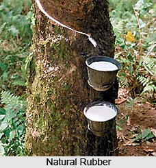
The soil in the three natural divisions generally fall under three types. In the highland region it is laterite soil. In the midland, the soil is a red ferruginous loam of laterite origin with an admixture of clay and sand. The coastal strip is sandy. Diversity of crops and heterogeneity in cultivation are the key notes of agriculture here. The eastern tract comprises of forests and hilly areas. The forests comprise a variety of timber and teak and other plantations. The hilly areas are mostly cleared and put to private cultivation; the important crops being rubber, cashew and ginger. In the skeletal plateau areas, cashew trees are cultivated, while in some patches, arecanut, pepper and cocoa are grown. In the coastal tract, paddy, coconut, arecanut, cashew, tobacco, vegetable and tapioca are cultivated. Compared to total production of state, the district produces 100 percent tobacco, 26 percent arecanut and 16 percent cashew nut.
Kasaragod district has immense potential for the establishment of large and medium scale industries, but the district is at present industrially backward. There is no major industry here. As per the latest data available, there are 5,759 small scale industrial units in the district. There are no large scale units in the district. Kasaragod has two medium industries, 62 industrial co-operative societies and 8 handloom societies.
Fisheries also contribute towards the economy. Kasargod district has an 80 Kms long sea coast extending from Trikaripur to Bangra-Manjeshwar. There are many fish landing centers in this district and transporting facilities. Bangra-Manjeshwar, Shriya, Koipady, Kavugoly, Kasaba, Kizhur, Kottikilam, Pallikara, Ajanur, Hosdurg Kadappuram, Thaikadappuram, Punjavi Kadappuram, Padanna Kadappuram, Kadankod, Valiyaparamba and Trikaripur Kadapuram are the fishing villages in this district.
For the development of agriculture in the district, the Central Plantation Crops Research Institute has been established. The objectives of the CPCRI are to serve as national forum for improving genetic potential of plantation crops, to conduct basic and applied research on various aspects of these crops, to co-ordinate research works being done by other institutions and agencies in the country, to serve as an information centre on all matters pertaining to these crops, to produce genetically superior planting materials and to carry out all India coordinated cropping improvement project on coconut, arecanut, spices and cashew nut. CPCRI was established in 1970 by the Indian Council of Agricultural Research. Research is carried out on various branches of Agricultural Sciences such as Gardening, soil chemistry, plant production, microbiology, plant diseases, cattle rearing, pisciculture, etc. This institute, apart from benefiting the district of Kasaragod has national importance as well. With headquarters at Kudlu, five kms. north of Kasargod, the CPCRI has regional stations at Kayamkulam, Vittal and Kozhikode. Its research centres are at Peechi, Palode, Hirehally, Appangala, Mohithnagar and Kehikuchi. There are seed farms at Kidu and Sathigode, one field station at Thrissur and a World Coconut Germplasm Centre at Sipighat. TxD, Mangala arecanut, new species of cardamom, turmeric and cashew, mixed crop and multi-crop system, etc. are some of the contributions of the CPCRI for the development of agriculture. The most remarkable venture is tissue culture in coconut. Research on various diseases of coconut, areacanut, cashew, pepper and field crops has given better yield.
Administration of Kasaragod District
 Kasaragod district was initially a part of the South Kanara district of the state of Tamil Nadu prior to the states reorganisation on 1st November 1956. On that day Kasaragod taluk was made part of the re-organised Malabar district of Kerala state. Two months later on 1st January 1957, the present region covered by Kasaragod district became a part of the newly formed Cannanore (later renamed as Kannur) district. Along with it the erstwhile Kasaragod taluk was bifurcated into Kasaragod and Hosdurg taluks. In 1984 Kasaragod became a new district with Kasaragod town as its headquarters.
The formation of Kasargod district was a long felt ambition of the people. It is with the intention of bestowing maximum attention on the development of the backward areas that Kasaragod district was formed on 24th May, 1984, as per GO.(MS)No.520/84/RD dated 19.05.1984. With the formation of the district, comprising the erstwhile Kasargod and Hosdurg Taluks it became possible to develop the area to its fullest potential. Kasargod consists of the hill tracts villages in the eastern side and coastal villages in the western side and it is the 14th district in the state.
For the purposes of revenue administration, Kasargod district is divided into two taluks, five firkas, and 75 villages. The only Revenue Division in the district is Kasargod and the office is at Kanhangad. The Collectorate functions at Vidyanagar in Chengala Panchayat, which is 5 Kms. from Kasargod town. The various subjects dealt with in the Collectorate are Revenue Establishment, Law and Order, Arms Act and rules, Explosive Act and rules, Government Building, PRB Act, Salary bill, LPC, vehicles, GPF, Natural calamity, Drought, Chief Minister`s Distress relief fund; Secret and confidential matters, Disciplinary action; Revenue Recovery, Land Assignment, Election, Building tax, Inspection and audit; Trees, Encroachment, mines and mineral, National Family Benefit Scheme, Lease, Freedom fighters pension, etc., Housing scheme; Excess land, Land Tribunals, Record, office purchase, stationery, Suit, Government Pleaders, Land acquisition and allied matters; Survey section; Fair copy and Despatch, e-mail etc.
The Panchayat system is followed for the purpose of convenience in rural administration. The Kasaragod District Panchayat has 15 constituencies. The elections here are held in two phases. There are a total of 4 block panchayats in the district. These are Manjeshwar, Kasaragod, Kanhangad, and Nileshwar. The total number of Gram Panchayats figure at 39. There are two municipalities at Kasaragod district, Kasaragod and Kanhangad.
Transport facility
Railways, roadways as well as airways connect the city.
Railway:
The total length of the district is 116 km. There are all total twelve-railway stations present in the district.
By utilizing the Konkan Railway, the district has shortest access to important cities like Mumbai, New Delhi, Pune, Goa, Karwar, Manglore, Rajkot, etc. Almost all express trains have the stop at Kasargod and Kanhangad Railway stations. So it has been seen that all total more than 15 express trains and few passenger trains pass through this district.
Airport:
The nearest airport of the district is Mangalore in Karnataka, which is 50 km from district headquarters. There is another airport that is also used by the residents of Kasaragod district. This is placed at Kozhikode district and is 250 km far away.
Roads:
The length of national highway is 86 km, state highway is 29 km, major districts Roads are 90 km, other district roads are 358km whereas village roads are 492 km.
Temples in Kasaragod District
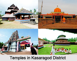 Kasaragod is fill up with several religious places. The following few are very renouned places. Such as:
Madiyan Kulom temple , Ajanoor: The famous Madiyan Kulom temple is situated at Ajanoor. It is placed at about five km from Kanhangad, which is the headquarters of Hosdurg taluk. The main deity of the temple is Bhadrakali. There are also some other deities like Kshetrapalan, Bhagavathi and Bhairavan. A peculiarity of this temple is that a Brahmin priest performs pooja only in the noon, while a sect or religion called Maniyanis performs the morning and evening poojas. The festival in the temple comes during the months of Edavam i.e. May-June and Dhanu i.e. December-January and on these days all the poojas are performed in connection with this festival.
Mallikarjuna temple: This temple is situated in the heart of the Kasargod town. This is one of the famous temples in kasargod district. The attraction of this temple lies in the temple festival and yakshagana.
>Ananthapura lake temple: This is the only lake temple in Kerala. This is also the Moolasthanam or original seat of Ananthapadmanabha Swami situated at Thiruvananthapuram. Which is placed at the distance of 5 km. from Kumbla. Local belief is that Ananthapadmanabha had settled down here originally. The industrial park of kinfra is situated here.
Perne:Out of the 28 Muchilottu Bhagavathi temples, Perne is the northern most. This is the only one situated at the direction of north of chandragiri seema and also in the vicinity of Ananthapuram. In the month of Meenam when pooram festival is celebrated the mass marriage organized at this temple, which is regarded as an unique features.
Trikkanad and Pandyan Kallu: This is a famous temple on the seashore situated near the Bekal fort. This temple is dedicated to lord siva, which is also known as dhakshina kashi. Pandyan Kallu is a rock rising in the sea about 2 km from trikkannad. It is an ideal place for adventurous swimmers. It has the legend that ship of one of the pandya king who attacked the trikkannad temple was converted into a rock by lord siva. Palakkunnu Bhagavathi kshethram is situated one km north of trikkannad. This is famous for annual bharani festival, which attracts thousands of devotees every year.
Tulur vanam:This is also known as Kekulom or the eastern place. This place near Panathur temple is sacred to kshethrapalan and bhagavathy. The eight-day annual festival, which is celebrated here at this place, attracts large crowd from all over the district as well as from Coorg.
Ashramas in Kasaragod
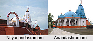 There are two prominent asramams in Kasaragod district in the Kerala state of India: Anandashram and Nityanandasramam. These two ashramas are blessed with deep peace and tranquillity and throughout the year they attract tourists from various parts of the country.
Anandashramam: Anandashramam is situated about five km east of the Kanhangad Railway Station. Swami Ramadas, a great Vaishnava saint of modern times, founded this ashramam in 1939. The main asramam and other buildings have a beautiful setting in the midst of shady mango, coconut and other groves. There is a hill to the east of the asramam. In this hill the devotees retire for quiet meditation. In the west direction, the surrounding extensive landscape can be seen in its natural grandeur. The spot at the highest point of the hill is very fascinating. The devotees, who go up the hill and sit silently, are blessed with deep peace and tranquillity.
Nityanandasramam: Nityanandasramam is situated on the hillock about half a km. south of the Hosdurg taluk office. This Ashrama was founded by Swami Nityananda. Earlier, the spot was part of a forest area. Swami Nityananda was a spiritual leader who offered a helping hand to the suffering and inspired his devotees to give up material desires. Here at this place Swami Nityananda constructed 45 guhas or caves in a mountain slope. A full size statue of Swami Nityananda in sitting posture made of panchaloha is one of the main attractions of the asramam. Close to this asramam is a temple built in the year 1963, after the style and design of the famous Somnath Temple in Gujarat. The nearest air route of Nityanandasramam is Mangalore Airport which is around 80 km away. The closest railway station is Kahangad Station.
Tourism in Kasaragod District
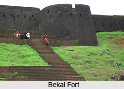 Kasaragod can be called as the land of seven languages and several cultures. This is the place of harmonious coexistence of Hindu, Muslim, and Christian religions. The district also has some famous tourist centres, including the international fame Bekal fort & beach. From ancient time Kasaragod district was famous. In 9th and 14th centuries AD Arab travelers came to Kerala and visited Kasaragod. The Bekal fort is of great historical and archaeological interest. It is the largest and best preserved of its kind in the district. The land, on which it is situated, runs into the sea with fine bay towards the south. There are some places, which can be converted to attract the tourists and thus promote the tourism in the district.
Bekal:Bekal is an important place of tourist interest in the district situated on the seashore of Pallikara village. It lies 12 km south of Kasargod town. According to Bekal Rama Nayak who was a local Kannada writer, the word, Bekal is derived from the word Baliakulam that means Big Palace. The term Baliakulam over a period of time got corrupted as Bekulam and later as Bekal.
Adoor: This place is situated at the distance of 45 km East of Kasaragod town. This place is famous for its ancient Siva Temple that was founded by Arjuna. According to legend this is the place where the Kiratha Yuddham battle between Arjuna and Lord Siva took place. Adjacent to this place there is a forest where men can`t go as such and this place is considered the abode of Lord Siva and his divine consort. The stream flows below the valley is the real gift of nature, which is a tourist attraction.
Ashramas in Kasaragod : nityanand asramam and Anandashram are the two remarkable asramams present in Kanhangad. Among them Anandashramam is situated about five km east of the Kanhangad Railway Station. Swami Ramadas, a great Vaishnava saint of modern times, founded this ashramam in 1939.
Bekal fort:This is the largest and best-preserved fort in the State. The alluring scene of the seashore and its exhilarating natural scenery and beauty attracts the visitors. This place is emerging fast as an International tourist center.
Bela church:This is our Lady of Sorrows Church, which is oldest in the district constructed long back in 1890 AD. This is situated at 15 km north of Kasargod. This ancient Roman Catholic Church, which is under the Manglore Territory, has celebrated its centenary recently and also renovated to reposition itself.
Bellikoth: This is another centre in Ajanoor village which is renowned as the birthplace of Poet P.Kunhiraman Nair. He was the veteran freedom fighter. The playwright Vidwan P.Kelu Nair and Rasika siromani Kanan Nair are also born here at this place. There is also a cultural center that is regarded as only one center of the district.
Chandragiri fort: Chandragiri fort lies three km south of Kasargod town. It has a large square situated high above the Chandragiri River on its southern bank.
Cheruvathur:This is actually the place of illustrious poets and scholars of Kuttamath Kunniyur family. The veeramala hill at this place has the ruins of a Dutch fort built in the 18th century. In present days this place is regarded as a picnic spot.
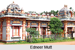
Edneer mutt: It is placed at the distance of 10 km. northeast of kasargod. This mutt belongs to the Sankaracharya tradition, presently renowned as a seat of art and learning.
Govinda Pai memorial:It is placed in manjeswar, which is the native place of govinda pai (1883-1963). He was one of the greatest kannada poets of modern time. He was conferred the title of "poet laureate" by the previous government of madras. He is known as rashtra kavi govinda pai.
Hosdurg fort: The fort with its round organization looks imposing from a distance. This fort was built by the Somashekara nayak of ikkeri dynasty. The place is distinguished by the nithyanandasram with its 45 caves.
Kammatam kavu: This is an evergreen forest of about 50-60 acres with a perennial stream. It is the center of worship connected with kammadam bhagavathi temple.
Kanjan junga:This is the place established by artist P.S.Pununchithaya. This is placed at 16 km east of kasargod. P.S.Pununchithaya was a renowned artist of the west coast.
Kariangode River: This river is running through the hills and dales of hosdurg taluk. It is placed in the famous village of kayyur, which is the cradle of agrarian revolutions. In this village the farmers and farm workers staged a historic battle against feudalism and the British imperialism.
Kasargod town:This municipal town is situated on the bank of river Chandragiri. This place is the confluence of several languages and culture where eight languages are spoken. The splendor of kasaragod saree comparable to that of kanjeepuram is a cynosure of the market.
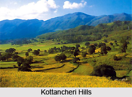 Kottancheri hills: This is the rain forest situated near Konnakkad. This is placed at 30 km northeast of kanhangad. The place is ideal for trekking as well as picnic. Thalakkaveri in the Brahmagiri Mountain of Coorg is also placed near to this hill. This is actually the reflection of genetic beauty of Kodaikkanal and has a tremendous scope for tourism.
Kottappuram:This mud fort was build by the Nileshwar rajas and later annexed by bednore nayaks in the 18th century. Near to this fort a juma masjid and a Hindu temple are placed to a close proximity.
Kudlu:This is actually the Kasargod suburb situated at 4km distance towards north. This is the place where the eight day long discourse between the Madhavcharya (Dwaita Philosopher) and the pandit (the famous adwaita scholar) took place.
Kumbala:This is placed at 13 km north of Kasargod. This is actually the ancient seat of rajas of Kumbala. The town stands on a bold peninsula in a lagoon separated from the sea by sand spit and connected to it by a narrow channel. Parthi Subbha who was the father of yakshagana was born here in the 18th century. Another famous temple named as Gopalakrishna temple is also situated at this place.
Madhur: Madhur is a Hindu Pilgrim centre, about 8 km from Kasargod , Kerala . The famous Srimad Anantheswara Vinayaka temple of Kerala is situated here at the distance of 8 km north east of Kasargod.
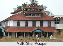
Malik dinar mosque:Over the years, Kasargod acquired the considerable importance as a center of Islam on the west coast. It is the one of the mosques that was founded by malik ibn dinar. At thalangara, the most attractive and best-kept sites are the mosque, juma masjid, which are located here. It also contains the grave of Malik Ibn Mohammed, one of the descendants of malik ibn dinar and the place is sacred to Muslims.
Maipady palace:This palace is situated at eight km. east of kasargod on the kasargod-perla road. There are various ancient palaces of kumbala rajas located in this place.
Manjeswar:This place lies in the northern most extremity of Kerala. This is a place of historical and religious importance. For a long time it was the seat of a flourishing community gowda saraswatha or konkini brahmins. This is also famous for the two old jaina bastis at bangra manjeswar and Manjula Kshethra Mahathmya a legend which deals with the history of this place. This is the birth place of rashtra kavi govinda pai.
Nellikunnu Mosque:This mosque is famous for uroos. Thousands of devotees come every year to visit the place. This is placed very near to kasargod town. The nercha celebration, which is celebrated during the second half of November, usually lasts for one week.
Nileshwar:This Nileswar is the abbreviated form of Nilakanta Iswar. Formerly this was the place of Nileshwar rajas that belonged to the Kolathiri family. The place witnessed the battle between bednore nayaks and nileshwar rajas. This is actually the cultural center of the district. In and around the place there are several kavus where nature, god and man commune serene silence. Among the major Kavus the mannan purathu kavu, where the grand finale of the annual temple festival of the region takes place is the main. Porattu of Anjoottambalam Veerarkavu also draws large crowds. Porattu is the satrical representation of everyday life presented in pageantry during the Pooram.
Posadigumpe:This is an ideal picnic centre and tourist resort that is located on a hillock at 487.68 metres above sea level. It is in Dharmathadka, which is situated at 30 km northeast of Kasargod. From the hilltop any one can see the Arabian Sea, Mangalore, Kudremukh, etc.
Povval fort: This is an old fashioned fort situated on the Kasargod-Mulleria route. This fort is placed at the distance of about 10 km from Kasargod.
Ranipuram: This is formerly known as Madathumala. This place is situated at the distance of about 48 km east of Kanhangad. This is lying 780 meters above sea level in beauty and boundary of nature comparable to Ooty even. This is also regarded as an ideal place for trekking. In the entire seasons tourist cottages are available here.
Trikaripur:This is the old seat of Thazekkattu Mana that is famous for T.S.Thirumumbu. He was the poet as well as freedom fighter. This place is also renowned as the birthplace of guru chandu panikkar who was the famous kathakali artist of Kerala.
Valiyaparamba: This is an island in the Arabian Sea placed 5 km south west of Cheruvathur. This is separated from the mainland by backwaters. This is one of the main tourist spots of the district. This is also an ideal place for picnic and fishing.
Veeramala hills: This place is situated at cheruvathur. This is actually a hilltop with ruins of a Dutch fort built in the 18th century. It is also a picnic spot from where the natural beauty of Kariangode River and surroundings can be enjoyed very well.
How to reach Kasaragod :
Roadways:The national highway is spread all over the district by 85.9 km. NH 17 which passes through this district mainly enters from Kannur side at Kalikadavu. It passes through all the major towns of the district such as Trikaripur, Cheruvathur, Nileshwar, Kanhangad, Kasargod, Kumbla, Uppla, Manjeshwar and enters Karnataka state at Thalappadi to Managlore.
Railways:Railways connect the district as Kozhikode-Mangalore-Mumbai route, which is 116 km long. Railway line passes parallel to the coastal line. The major Railway stations are Trikaripur, Cheruvathur, Nileshwar, Kanhangad, Kasargod, Kumbla, Uppla and Manjeshwar. Almost all Express trains will stop in these stations.
Airport:The nearest airport is situated in Mangalore, which is 70 km away. The other airports are situated at Kopzhikode or Calicut, which is 200 km away, at kochi or Cochin which is 350 km away.


