
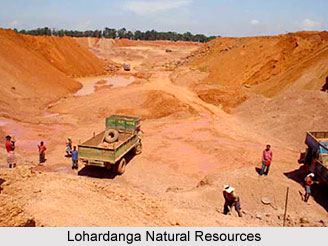
 Minerals:
The laterite and bauxite are the main mineral resources of this district. In addition to this china clay is also found here. In the North west of Lohardaga there is a mountain part that is spread like a wall. This is a vast godown of bauxite. In addition to the petty contractors, two main aluminum companies` extract bauxite from this area. It has been said that this bauxite is spread in this area for 60-70 years.
Soil & River:
The quality of soil and river in this district is very unusual. Major part of the area is covered with red laterite acidic soil. Morum, forest and stone, etc generally cover the upland. The Major rivers of this district are koyal, sankh, Nandani, sahi, fulshar. These rivers are generally rainy rivers.
Flora & Fauna:
One important part of the district is, it is covered with forest. The district has about 27% of forest area while other areas are also covered with lush green forest. Important forest products are Saal seeds, Kokun, Lac, Tendu leaves, Karanj, Chiraunji etc. The major trees can be named as Sal Bija, Gamhar, Kathal, Jamun, Mango, Bamboo, Neem etc.
Industry:
In Lohardaga district, small scale industries are there which are mainly based on agriculture, forest, mining, machinery fabrication, leather goods, electric, printing press, Kalin Industry, Road transportation etc. Many labors are engaged in these works and maintain their livelihood based on this work. Average annual income of each entrepreneur is quite good and is enough to maintain the family. Bauxite is extracted from this area and it is done by the two major aluminum companies other than some petty contractors.
Agriculture and irrigation:
Mineral wealth is found everywhere in the district. But the farmers here are mainly depended on agriculture. Almost 79% of the total work force of the district depends on agriculture and so related activities. Due to erratic rain, obscene of irrigational facilities, the farmers are not able to grow enough to supplement their food. And this is why they keep on migrating to other places.
The district comes under the influence of three river systems namely the Damodar or Ganga basin, North Koel and South Koel. The district has a surface flow of 481 MCM that is still untapped. Most of the nallahs have enough flow during the monsoon but the flow is considerably reduced in bean periods and these are not enough storage even for individual pump sets.









