
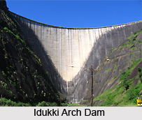
 The Idukki Dam stands across the Periyar River, in the canyon lying between the Kuravan and Kurathi Hills in the southern Indian state of Kerala. The dam rises to an elevation of 167.68 meters and is one of the highest arch dams in Asia. Idukki Dam started generating power on 4 October 1975. Technically, the dam is a concrete double, curvature parabolic and thin arc type.
History narrates that in 1922 Shri Kolumban, the head of `Araya` showed the way to the Malankara Estate Superintendent and also to his friend Thomas. They were on hunting spree in the forest, the spot of present Arch Dam. He told them of the legend of Kuravan and Kurathi Hills. Thomas was moved by the sight of water flow between the mountains and his idea made the dream come true of Idukki Arch Dam. Later in 1932, Sri W.J.John of Malankara Estate submitted a report to the Government of Travancore on the possibility of constructing a dam at Idukki for Power Generation.
In 1947 Sir P.Joseph John, who was Chief Electrical Engineer to the Government of Travancore at that time made a preliminary investigation report. On Government`s request, the Central Water and Power Commission took up detailed investigation in 1956. The project report was prepared in 1961 and the Planning Commission sanctioned the implementation of the scheme in 1963 and the preliminary works of the project were started. The project was placed for Canadian assist and its scope was distended and a revised project report was drawn up in 1956-66.
The construction of this Dam commenced on 30 April 1969 and storage of water in Idukki reservoir commenced in February 1973. The inauguration of trial run of the first machine was celebrated on 4th October 1975. Hon. Prime Minister Smt. Indira Gandhi commissioned Commercial operation of the Power Station on 12 February 1976. Construction of this Arch Dam and two other dams at Cheruthony and Kulamavu has created an artificial lake of 60 sq. kms width. The water stored of this lake is utilized for production of electricity at the unique Moolamattom Power house. This is located inside the rocky caves.









