 Sholapur district is an important junction on the north-south railway line. The city of Solapur is the district headquarters. The district is located on the south east edge of the state and lies entirely in the Bhima and Seena basins. Solapur District also leads in beedi production. Sholapur is derived from two words `Sola` means sixteen and `Pur` means Village. The present Solapur was considered to be spread over sixreen villages.
Solapur District
Solapur is a city of Maharashtra and is a leading centre for cotton mills and power looms.
Introduction
Sholapur district is an important junction on the north-south railway line. The city of Solapur is the district headquarters. The district is located on the south east edge of the state and lies entirely in the Bhima and Seena basins. Solapur District also leads in beedi production. Sholapur is derived from two words `Sola` means sixteen and `Pur` means Village. The present Solapur was considered to be spread over sixreen villages.History of Solapur District
 The history of Solapur district is one of dynastic rule. It has been ruled by many dynasties such as the Andhrabhratyas, the Chalukya dynasty, the Yadavas and the Bahamanis. The name Solapur is believed to be derived from two words `sola` meaning sixteen and `pur` meaning village. Present Solapur was considered to be spread over sixteen villages viz. Adilpur, Ahmedpur, Chapaldev, Fatehpur, Jamdarwadi, Kalajapur, Khadarpur, Khandervkiwadi, Muhammadpur, Ranapur, Sandalpur, Shaikpur, Solapur, Sonalagi, Sonapur and Vaidakwadi. However, recent research works points to an altogether different reason behind the name of Solapur district.
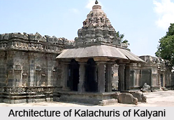
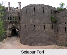
It is evident from the inscriptions of Shivayogi Shri.Siddheshwar of the time of the Kalachuris of Kalyani, that the town was called `Sonnalage` which came to be pronounced as `Sonnalagi`. The town was known as Sonnalagi even until the times of the Yadavas. A sanskrit inscription found at Kamati in Mohol and dated 1238, after the downfall of the Yadavas, shows that the town was known as Sonalipur. One of the inscriptions found in Solapur fort shows that the town was called Sonalpur while another inscription on the well in the fort shows that it was known as Sandalpur. During the Muslim period, the town was known as Sandalpur. It is therefore most probably that that during the course of time the name Solapur was evolved by dropping `na` from the name Sonalpur. Subsequently the British rulers pronounced Solapur as Sholapur and hence the name of the district.
The importance of Solapur is unique in the history of India in the sense that this district enjoyed freedom even before independence. The citizens of Solapur enjoyed the Independence for three days from 9th to 11th May 1930. The brief history runs like this. After the arrest of Mahatma Gandhi in May 1930, protests and demonstrations against the British Rule were held throughout India. Large scale rallies and protests were done at Solapur also. Many citizens lost their lives in the police firings. Due to this the irate mob attacked the Police Stations. Out of fear the police and other officers ran out of Solapur. During this period the responsibility of law, order and security of citizens was on the shoulders of congress party leaders. Then city congress President Shri Ramkrishna Jaju, with his other congressmen maintained the law and order for a period of three days from 9th to 11th May 1930.
Secondly, the Solapur Municipal Council was the first Municipal Council of India to host the National Flag on the Municipal Council building (Now Municipal Corporation) Solapur in 1930. Taking the spirit of Dandi March from Mahatma Gandhi, the freedom fighters of Solapur decided to host the National Flag on the Solapur Municipal Council. Accordingly, a senior freedom fighter from Pune Shri.Annasaheb Bhopatkar hosted the National Flag on 6th April 1930 on Municipal Council. This was the first and most unique incidence of its kind throughout the country. The British rulers declared Marshall Law at Solapur and arrested many leaders and innocent citizens on false charges. The freedom fighters Shri.Mallappa Dhanshetti, Shri.Kurban Hussain, Shri.Jagnnath Shinde and Shri.Kisan Sarda were arrested on charges of killing two Policemen of Mangalwar Police Station. The lower court sentenced the punishment of hanging till death for these freedom fighters. The High Court also confirmed the same decision and these four freedom fighters were hanged till death on 12th January 1931. As a mark of respect to these freedom fighters, the Statues of these freedom fighters have been installed in the heart of the city and the location has been named as Hutatma Chowk.
The present Solapur district was previously part of Ahmednagar, Pune and Satara districts. In 1838 it became the Sub-district of Ahmednagar. It included Barshi, Mohol, Madha, Karmala, Indi, Hippargi and Muddebihal Sub-divisions. In 1864 this Sub-district was abolished. In 1871 this district was reformed joining the Sub-divisions viz. Solapur, Barshi, Mohol, Madha and Karmala and two Subdivisions of Satara district viz. Pandharpur, Sangola and in 1875 Malshiras Sub-division was also attached. After the State reorganisation in 1956 Solapur was included in Mumbai State and it became a full- fledged district of the state of Maharashtra in 1960.
Geography of Solapur District
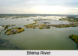 Geographically Solapur is located between 17.10 to 18.32 degrees north latitude and 74.42 to 76.15 degrees east longitude. The district is situated on the south eastern fringes of the state of Maharashtra and the district is bounded on the north by the Ahmednagar district and Osmanabad district, on the east by Osmanabad and Gulbarga district of the state of Karnataka, on the south by Sangli and Bijapur district and on the west by Pune and Satara district. The major rivers in the district are the Bhima River and the Sina River. The Nira River, Mann River and Bhogawati are its tributaries. The district lies entirely in the Bhima and Sina basins. The whole of the district is drained either by the Bhima River or its tributaries. The Bhima and Sina run south-east. The Nira and Mann run nearly east.
The district in general has a flat or undulating terrain. There is no important hill system in the district. Only to the north of Barshi Taluka, several spurs of the Balaghat range pass south for a few kilometres. There are also a few scattered hills in Karmala, Madha and Malshiras Talukas The low table land and small separate hills in Karmala and Madha Talukas act as a watershed between the Bhima and Sina rivers. The soils of the district can be classified into three main types. These are black soil, coarse grey soil and reddish soil.
According to topography the district is divided in three natural zones:
 Eastern Zone: This comprises of Barshi, North Solapur, South Solapur and Akkalkot Talukas. The soil is medium to deep black and of rich quality. jowar, bajra and pulses are the main crops of this zone.
Central or Tansitional Zone: Mohol, Mangalwedha, eastern part of Pandharpur and Madha Taluka are covered by this zone. Moderate soil and uncertain rainfall marks this zone. Both Kharif and Rabi crops are grown in this part.
Eastern Zone: This comprises of Barshi, North Solapur, South Solapur and Akkalkot Talukas. The soil is medium to deep black and of rich quality. jowar, bajra and pulses are the main crops of this zone.
Central or Tansitional Zone: Mohol, Mangalwedha, eastern part of Pandharpur and Madha Taluka are covered by this zone. Moderate soil and uncertain rainfall marks this zone. Both Kharif and Rabi crops are grown in this part.
Western Zone: Karmala, Sangola and Malshiras Talukas and the western parts of Pandharpur come under this zone. Shallow and poor type of soil, not retentive of moisture marks this part, along with scanty and uncertain rainfall. Rabi crops are mainly grown in Karmala, Pandharpur and Madha Talukas while Kharif crops like bajra and groundnut are grown in Sangola and parts of Malshiras talukas.
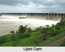
Agro-climatically, the entire district comes under the rain shadow area. Rainfall is uncertain and scanty. The monsoon period is from the second fortnight of June to the end of September bringing rains from south-west monsoon. The average rainfall for the district is 545.4 mms. Due to scanty and non-uniform rains, scarcity conditions prevail in the district. This has adversely affected the socio-economic condition of people. In order to face this situation, the Ujani dam has been built to provide water to the drought-prone areas. During the dry season all the rivers are nearly dry. The length of Bhima River in Solapur district is 289 kms. An area of 296107 hectares is under irrigation in the district from various sources.
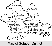
The district covers a total geographical area of 14844.6 sq.kms which is 4.82 percent of the total area of the state of Maharashtra. Out of the total area of the district 338.8 sq.kms (2.28 percent) is urban area whereas the remaining 14505.8 sq.kms. (97.72 percent) is rural area. Area wise, Karmala taluka is the biggest covering an area of 1609.7 sq.kms and North Solapur is the smallest covering an area of 736.3 sq.kms.
Economy of Solapur District
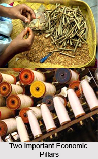 Economy of Solapur district is quite developed where its industries are concerned. It is situated at an important junction of the North-south railway line and is consequently a good place for industries to be set up. There are a number of medium and small scale and medium industries found in the district, and it is one of the prime centres of the Handloom and Powerloom industry, cotton mills and the beedi industry. Solapur is well known for the bed sheets produced here, and has a reputation for the same. Textiles therefore figure in a big way in the economy of the district. In the agricultural field, the district has a well established market in oilseeds. The major crops grown in the district include jowar, wheat and sugarcane.
Handloom and Powerloom Industry
Solapur is the home of Handloom and Powerloom weaving industry which provides employment to a large number of workers. There are around 6000 powerloom industries operational in the district. Out of these 300 establishments are registered under Mumbai Shops and Societies Act 1948 and the other 3000 are registered under Factories Act 1948. There are about 25000 Powerloom and about 30000 workers are employed. On the Jackard powerloom the main production is chadders, towels and napkins. These products are exported to various countries in the world. The employees working on the handloom or powerloom machines mainly manufacture Jackard Chadders, Towels and Napkins. These workers receive their payments on the `Piece Rate` basis, based on category of the product. As the `Piece Rates` of various products are different there is variation in workers earnings. As per the traditional piece rate system the worker gets Rupees 70 to 90 per day on an average.
Beedi Industry
Beedi industry is the second important industry in Solapur district. Beedi is basically a kind of local cigarette, where tobacco is wrapped in a tendu leaf and tied at the end with a coloured thread. The work of beedi rolling falls under the category of cottage industry. Typically women are employed in these industries and they work from home. The largest beedi-producing industry in the state of Maharashtra is in the district of Solapur. There are 115 units of 29 various beedi factories. In these 115 units there are about 70000 lady workers and 1725 factory workers in the district.
Thus discussed is the economy of Solapur district, dependent as it were, on the handloom and beedi industries.
Governance of Solapur District
District Collector is mainly responsible for the District Administration. The District Collector is assisted by Resident Deputy Collector and the Sub-Divisional Officers to maintain the law and order of the district.
Division of Solapur District
The Solapur district comprises of three revenue Sub-divisions, eleven revenue Talukas and 1144 revenue villages.
Demographics of Solapur District
As per 2001 Census of India, Solapur had total population of 3849543. Total male population was 1989623 and total female population was 1859920. Total Literacy rate is 71.2%. Male literacy rate is 82.0%, where as female literacy rate is 59.8%.
Culture of Solapur District
 Marathi is the main language spoken in Solapur. Kannada and Telugu are spoken in border areas of the district. There are several regious places in Solapur. They are:
Pandharpur: It is a holy place of Shri.Vitthal and Shri.Rukmini. It is also known as the Southern Kashi of India and Kuldaivat of Maharashtra State. It is located at a distance of 72 kms by road from Solapur District headquarters.
The ancient temple of Shri.Vitthal was renovated in 1195 A.D. There are many other temples of Indian Deities and Mathas (Dharamshalas) of many Saints. The Chandrabhaga (Bhima) river flows through the City. Large number of devotees from all over Maharashtra and surrounding States gather at Pandharpur mainly to celebrate the Aashadhi and Kartiki Ekadashi every year in addition to the regular rush of devotees everyday. The Palanquins (Palkhi) of various Saints originating from various locations gather at Wakhari, five kms from Pandharpur for the Waari festival.
Siddheshwar Temple: Shri.Siddheshwar is the Gramdaivat of Solapur city. A Siddheshwar Temple is located at the heart of the city. It is surrounded by a large water tank, which resembles as view of an island. The brief history of Shri.Siddheshwar runs like this. There was a great saint Shri.Siddaram, who preached the teachings of Shri.Basaweshwara. A young girl, inspired by the teachings of this saint wished to marry the saint. Shri.Siddaram being a brahamachari denied to marry her and gave permission to marry with his Yogadanda. The same marriage function is celebrated every year on the Makar Sankranti for three days on Bhogi, Sankrant and Kinkrant. The Nandi Dhwajas are presumed as Bride and Groom for the marriage. This festival falls around 14th Jan. every year. A fare popularly known as Gadda Jatra is arranged for fifteen days during this period.
Akkalkot: It is a holy place of Shri Swami Samarth Maharaj. It is located at a distance of 38 kms by road from Solapur District headquarters. This Saint is believed to be the reincarnation of Lord Dattatraya. The Samadhi of this Saint is worshipped by the devotees. The Death Anniversary is celebrated on Chaitra Shuddha Trayodashi every year.
 Kamala Devi of Karmala: The Kamala Bhavani Temple is built by Rao Raje Nimbalkar in 1727. It is considered to be the second seat of Tulajapur Tulaja Bhavani. Built in Hemdpanthi style, the temple has entry doors in East South and North directions. The uniqueness of this temple architecture is, the temple is having well of 96 steps. The temple is constructed with 96 pillars. The temple top consists of 96 pictures and 96 `overyas`.Navratri festival is celebrated with great devotion. The annual festival (yatra) is held during Kartik Purnima to Chaturthi.
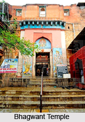
Barshi- Barshi is famous for Bhagwant temple. The temple is dedicated to Shri Vishnu. The uniqueness of this temple is that, this is the only one temple of Shri Vishnu all over India having Shri Vishnu`s name as BHAGAWNT. The temple is built in Hemadpanthi style in the year 1245 A.D. There are four entries to the temple from all the four directions, but the main entry is east facing. Large number of devotees visits during the Chaitra, Maghi, Aashadi & Kartiki, (Hindu Months) and Ekadashi. During the Aashadi & Kartiki Ekadashi a large procession is taken out covering the town with Bhagwant riding on Garuda.
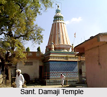
Mangalwedha- Magalwedha is famous for Sant. Damaji. The temple by the name of the Shri. Sant Damaji is located in the heart of the city.
The other tourist places of Solapur are including Kundalsangam,Akluj, Nanaj(North Solapur taluka), Dahi gaun, which is famous for its Jain temple.
Like other Indian cities, Solapur also celebrates Holi, Janmashtami, Ganesh Chaturthi, Dussehra, Diwali, Navratri and Gudi Padwa. Lavani, Gondhal, Dhangari,Aradhi and Bhalari songs are the folk songs of Solapur.
Flora and Fauna of Solapur District
Solapur`s flora and fauna includes its wild life sanctuary.
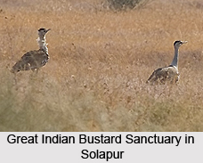
The Government of Maharashtra declared Great Indian Bustard Sanctuary in 1979 with the sole objective of conserving the rarest species of Great Indian Bustard, which are endangered with extinction. The sanctuary consists of the area of North Solapur, Madha, Mohol and Karmala Talukas of Solapur District and Karjat, Shrigonda, Newasa Talukas of Ahmednagar District covering a total area of 8496.44 sq.kms.This bird has been included in the Schedule-1 of Wildlife Act 1972 and accordingly due protection has been given to this bird. The headquarters of the sanctuary are Nannaj of Solapur District and Rehekuri of Ahmednagar District.
The other salient feature of the Sanctuary is Maldhok wild life sanctuary. It is coming under Ninnaj taluka. It has total geographical area is of 8496.44 sq.kms. Here the forest is tropical thorn forest. The main trees found in the sanctuary are Neem, Sishu, Babul, Bor, Tarwad, Henkal, Dongri, Kusali Pavanya, Sheda, and Marvel etc. the common species of this forest are the Great Indian Bustard, Blackbuck, Wolf, Indian Fox, Jackal etc.
The other salient feature of the Sanctuary is Maldhok wild life sanctuary. It is coming under Ninnaj taluka. It has total geographical area is of 8496.44 sq.kms. Here the forest is tropical thorn forest. The main trees found in the sanctuary are Neem, Sishu, Babul, Bor, Tarwad, Henkal, Dongri, Kusali Pavanya, Sheda, and Marvel etc. the common species of this forest are the Great Indian Bustard, Blackbuck, Wolf, Indian Fox, Jackal etc.
Education in Solapur District
The important Institutions of Solapur are-
Government Polytechnic Solapur
 Solapur University
College Of Pharmacy-One of the premeir institute in Maharashtra offering Pharma education.
R.Y.Patil M.Pharm(Pharmacology) is the principal of this prestigious institute.21 students out of 43 have been qualified in GATE-2007 from this college.
Bharatratna Indira Gandhi College of Engineering
Walchand Institute of Technology
Dr. Vaishampayan Memorial Government Medical College
Pandit Deen Dayal Upadhyay Dental College
College of Architecture
Dayanand Institutions-Founded in 1940. It is located on a campus of 65 acres (26 ha) of land with four colleges and one high school and a model school. The oldest college in Solapur University.
Ashwath Infotech Pvt. Ltd
Indira Gandhi Engneering college, Kegav, Solapur
S.P.M.Polytechnic,kumath
Brahmdevdada Mane Institute of Technology
Belati.SES Polytechnic
S.S.S M`S college of Architecture.
Government Polytechnic Solapur
Solapur University
College Of Pharmacy-One of the premeir institute in Maharashtra offering Pharma education.
R.Y.Patil M.Pharm(Pharmacology) is the principal of this prestigious institute.21 students out of 43 have been qualified in GATE-2007 from this college.
Bharatratna Indira Gandhi College of Engineering
Walchand Institute of Technology
Dr. Vaishampayan Memorial Government Medical College
Pandit Deen Dayal Upadhyay Dental College
College of Architecture
Dayanand Institutions-Founded in 1940. It is located on a campus of 65 acres (26 ha) of land with four colleges and one high school and a model school. The oldest college in Solapur University.
Ashwath Infotech Pvt. Ltd
Indira Gandhi Engneering college, Kegav, Solapur
S.P.M.Polytechnic,kumath
Brahmdevdada Mane Institute of Technology
Belati.SES Polytechnic
S.S.S M`S college of Architecture.
Recently updated articles in States of India

History of Thissur District
Early History of Thissur District explains flourishing of the port cities. Now these port cities are transformed into archaeological sites.

Tippi Orchid Research Centre, Arunachal Pradesh
Tippi Orchid Research Centre in Arunachal Pradesh is renowned for its rich collection of exotic and endangered orchids. Surrounded by lush rainforest...

Tourism in Nashik District
Pilgrimage tourism in Nashik district involves visiting the various places of Hindu and Jain worship located here. Some of the holiest sites for Hind...

Mangadu, Kerala
Mangadu in Kerala’s Kollam district is a significant megalithic site known for its urn burials, cist burials, menhirs, and stone circles. Excavations...

Devaswom
History of Devaswom is not very ancient and can be dated back to late seventeenth century.
Related articles in States of India

East Indian States
East Indian States comprises of Bihar, Jharkhand, West Bengal, Odisha and also the Union Territory of Andaman and Nicobar Islands. It defines the cult...

Purnia District in Bihar
Purnia District is located in Bihar and extends from River Ganga to Nepal. The district has a rich Hindu history and glorious past.

Hooghly district
Hooghly District along the bank of the river Hooghly is one of the principal trading ports of West Bengal.

Geography Of Chittoor District
Geography of Chittoor district is spread along the topography of the land which is divided into two natural divisions; Chittoor has a dry and healthy...

Districts of West Bihar
Districts of West Bihar is comprised of medieval monuments that were built by the different governors of Mughal era.