
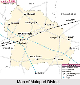
 Mainpuri District is an administrative district of Agra Division in Uttar Pradesh. Mainpuri town is the district headquarters. Mainpuri District is bounded on the north by Etah District, on the east by Farrukhabad District and Kannauj District, on the south by Etawah District and on the west by Firozabad District and Etah District. It lies between 26 degree 53 minutes to 27 degree 31 minutes north latitude and 78 degree 27 minutes to 79 degree 26 minutes east longitude. Total area of Mainpuri District is 2760 sq kms. According to 2001 Census, total population of the district is 1596718, of which male population is 859934 and female population is 736784. Literacy rate of the district is 65.09 percent. The common dialect of the people in Mainpuri District is Braj Bhasha which is the oldest form of Hindi language.
Mainpuri District
Mainpuri District is one of the main commercial centres of Uttar Pradesh. Mainpuri District has a sound agricultural base but the industrial potential is low.
Introduction
Mainpuri District is an administrative district of Agra Division in Uttar Pradesh. Mainpuri town is the district headquarters. Mainpuri District is bounded on the north by Etah District, on the east by Farrukhabad District and Kannauj District, on the south by Etawah District and on the west by Firozabad District and Etah District. It lies between 26 degree 53 minutes to 27 degree 31 minutes north latitude and 78 degree 27 minutes to 79 degree 26 minutes east longitude. Total area of Mainpuri District is 2760 sq kms. According to 2001 Census, total population of the district is 1596718, of which male population is 859934 and female population is 736784. Literacy rate of the district is 65.09 percent. The common dialect of the people in Mainpuri District is Braj Bhasha which is the oldest form of Hindi language.History of Mainpuri District
 Early history of Mainpuri District is not very clear as it lacks proper evidences. But, villages and towns give abundant evidences, in the coins and fragments of masonry and broken pottery which they contain. These remains prove that these sites have been continuously inhabited by civilized communities from a very remote antiquity. But the only historical facts to be gleaned from the testimony of these mute memorials are the continuity of civilization in the region now included in the Mainpuri District and a knowledge of the kingdoms to which it at different times belonged. After Gupta Empire, Mainpuri was included in Harsha`s kingdom of Kannauj for several centuries.
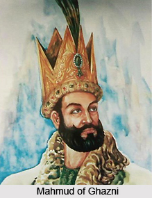
In 1018 AD Mahmud of Ghazni, after sacking undefended Muttra, marched across Mainpuri on his way towards Kannauj. From this time onwards Mainpuri was invaded by Muslim rulers. It was at this period, according to the historical accounts that the Chauhans migrated from Delhi southwards, establishing themselves in Mainpuri District and spreading over the adjoining districts. Two important local divisions of the territory which now makes up the Mainpuri district were Rapri and Bhongaon, was said to have been founded by Rao Zorawar Singh. After the defeat of Jaichand in 1194 AD the victorious army marched southwards against the raja of Rapri and defeated him. In commemoration of the victory the name of the small village where the battle was fought was changed from Karkha to Fatehpur. However, Rapri remained the seat of government for several centuries under successive Muslim rulers. However, Bhongaon on the other hand, remained under the Hindu rules without interruption.
After several years of turmoil and confusion Syed Khizr Khan succeeded in 1414. Rapri was still in the hands of Muslim rulers but the rest of the neighbouring Doab was evidently as insubordinate as ever. Further, in 1426 Jaunpur king, Ibrahim Shah made another attempt on Delhi, but was defeated in a pitched battle and his force retreated by Rapri to their own country. In Akbar`s great reorganization of his empire, the tract, which is now included in Mainpuri District was all included in the subah of Agra, and divided between the sarkars of Agra and Kannauj. These sarkars were further subdivided, for revenue purposes, into mahals, on each of which a certain fixed sum was assessed and from which a certain contingent of troops was levied. Under the rule of Akbar and his successors Jahangir and Shah Jahan, Mainpuri and its neighbourhood enjoyed a long quiet period, which continued unbroken during the long reign of Aurangzeb (1658-1707), though the rest of the empire was now suffering from the inroads of the Marathas.
Eventually, with the invasion of British rulers, Mainpuri became the headquarters of the civil administration and small cantonments were established at Shikohabad. This district was highly influenced by the freedom movements that started throughout the country. Thus, the history of Mainpuri District suggests that the region covered by the present district formed part of ancient kingdoms like Maurya Empire and Gupta Empire and of Harshavardhan.
Geography of Mainpuri District
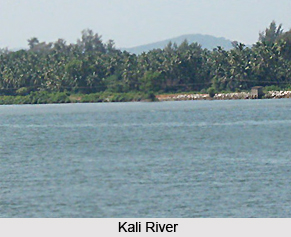 Geography of Mainpuri District generally presents the appearance of an extensive level plain broken only by the sand ridges on the western border. It also includes the rolling sand hills and undulations of Kali River and Isan River, and the ravines along Yamuna River to the south-west. Kali River forms the boundary of this plain on the north and north-east and the Yamuna River encloses it on the south-west. Both these rivers flow towards the south-east, and between them, in almost parallel courses, run the four smaller streams, Isan, Arind, Sengar, and Sirsa, following the general slope of the country from north-west to south-east.
Soils of Mainpuri District are typical of those found elsewhere in the Indo Gangetic Plain. These are classified on two principles accordingly as the distinctions recognised are natural or artificial. The distribution of these soils appears to be connected with the rapidity of the drainage of surface water from almost flat alluvial plain, for sand is found wherever there is a river with a comparatively deep bed within a few miles, and clay is common east near swamps and other ill-defined drainage lines.
Kali River forms the north-eastern boundary of Mainpuri District separating it from Etah District and Farrukhabad District. It is a narrow stream, but perennial, and even during the spring and summer month is navigable at certain places. Next to this river comes the Isan, which is a considerable stream, fordable only in a few places in the rains. But during the rest of the year the volume of running water is small, and in years of unusual drought there is no apparent stream. Rind River, a tributary of Yamuna River, is a very insignificant stream in this district. It enters at the north of Pargana Mustafabad, and traverses in an exceedingly sinuous course from the extreme north-west to the extreme south-east corner of the district.
The general slope of the district is from north-west south east, and this is the direction in which the rivers run and which is therefore followed in the main by the drainage. There are however, numerous inequalities of surface caused by the elevation of the river beds and by the sand ridges. And the general disposition of the drainage system differs in different portions of the district. Mainpuri District is a well wooded district on the whole apart from the comparatively bare user plains. The district is, however, poor in natural resources.
Economy of Mainpuri District
Economy of Mainpuri District is entirely dependent on agriculture. Agricultural year is divided into the three main seasons of harvests - kharif, rabi and zaid. Main kharif cereals in the district in order of the area they cover are maize, bajra, pulses and rice. Barley, gram, pea and mustard are main rabi crops cultivated in the district. Mainpuri District has ample means of irrigation like canals, wells, including tube-wells, and rivers. The rivers are not of much direct use for irrigation, well and tube-wells constitute a major and more reliable source of irrigation.
Lack of enterprise and technical training and insight among the people has been the major constraint in the industrial growth of Mainpuri District.
Lack of enterprise and technical training and insight among the people has been the major constraint in the industrial growth of Mainpuri District.
Recently updated articles in States of India

Bandare Waterfalls, Meghalaya
Bandare Waterfalls in South Garo Hills, Meghalaya, is a secluded natural attraction surrounded by dense subtropical forests and rugged mountain terrai...

History of Thissur District
Early History of Thissur District explains flourishing of the port cities. Now these port cities are transformed into archaeological sites.

Tippi Orchid Research Centre, Arunachal Pradesh
Tippi Orchid Research Centre in Arunachal Pradesh is renowned for its rich collection of exotic and endangered orchids. Surrounded by lush rainforest...

Tourism in Nashik District
Pilgrimage tourism in Nashik district involves visiting the various places of Hindu and Jain worship located here. Some of the holiest sites for Hind...

Mangadu, Kerala
Mangadu in Kerala’s Kollam district is a significant megalithic site known for its urn burials, cist burials, menhirs, and stone circles. Excavations...
Related articles in States of India

East Indian States
East Indian States comprises of Bihar, Jharkhand, West Bengal, Odisha and also the Union Territory of Andaman and Nicobar Islands. It defines the cult...

Purnia District in Bihar
Purnia District is located in Bihar and extends from River Ganga to Nepal. The district has a rich Hindu history and glorious past.

Hooghly district
Hooghly District along the bank of the river Hooghly is one of the principal trading ports of West Bengal.

Geography Of Chittoor District
Geography of Chittoor district is spread along the topography of the land which is divided into two natural divisions; Chittoor has a dry and healthy...

Districts of West Bihar
Districts of West Bihar is comprised of medieval monuments that were built by the different governors of Mughal era.