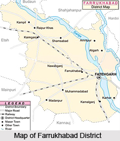
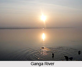
 Farrukhabad District forms part of Kanpur division in Uttar Pradesh. Fatehgarh is the district administrative headquarters. Farrukhabad District is situated between 26 degree 46 minutes north latitude and 27 degree 43 minutes north and 79 degree 7 minutes east and 80 degree 2 minutes east longitude. This administrative district of Uttar Pradesh is bounded by Badaun and Shahjahanpur on the north, Hardoi on the east, Kannauj on the south and Etah and Mainpuri on the west. The township of Farrukhabad, Fatehgarh consists of two district towns, Farrukhabad and Fatehgarh, former being the headquarters of the Tehsil, both lying about 5 kms apart. Ganga River and Ramganga River are located towards the east and Kali River towards the south.
History of Farrukhabad District
Farrukhabad District was founded by Nawab Mohammad Khan Bangash, who named it after the reigning emperor Farrukhsiyar in 1714. Fatehgarh derives its name from an old fort. Fatehgarh remained a Military Station of considerable importance and in 1802 it became the headquarters of the Governor Generals Agent for the ceded provinces. In the year 1818 a gun carriage factory was established here.
Geography of Farrukhabad District
Geography of Farrukhabad District comprises plain lands, varied only by a few gentle undulations and slopes, sometimes abrupt, which lead down to the river valleys. The highest recorded elevation is 167 metres above sea level at Mohammadabad and the lowest recorded elevation is 145.69 metres at Mau Rasulpur in the Trans Ganga flats of Tehsil Farrukhabad.
 The only marked variation of level is between the two divisions, the upland or bangar, which is a continuation of the Doab and the low lands, cut away from the upland by erosive action of the rivers. Farrukhabad District has a moderate climate with a hot dry summer and a pleasant cold season.
Administration of Farrukhabad District
Administration of Farrukhabad District consists of three Tehsils with a total area of 2, 28,830 hectares. The three sub-divisions of Farrukhabad District are Farrukhabad, Kaimganj and Amritpur. Further, it has seven Development Blocks namely Barhpur, Kamalganj, Mohammadabad, Kaimganj, Nawabganj, Shamshabad and Rajepur. Administrative set-up of Farrukhabad District includes 512 Gram Panchayats, 1020 Revenue villages, 14 Police Stations, two Nagar Palikas and four Nagar Panchayats.
Tourism in Farrukhabad District
There are several tourist places in Farrukhabad District. Tourism in this district offers visits to several historical and religious sites. Kampil is one of the major places of attractions in Farrukhabad District situated at about 45 kms from district headquarter in Tehsil Kaimganj. It is a place of great antiquity and is said to have been founded by the Sant Kampila. The temple of Rameshwarnath Mahadev, which stands in the town, is very old. Another popular place of interest in this district is Sankisa that is situated at about 38 kms to the south-west of the district headquarters. According to the Buddhist beliefs it is said that it was here that Lord Buddha descended again. These sites are worth seeing.
Farrukhabad District is well connected by roadways as well as railways. It is around 140 kms by road from Kanpur, near about 70 kms from Hardoi, approximately 190 kms from Lucknow.


