
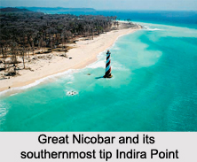
 Great Nicobar, referred to as "Tokieong Long" in the Nicobarese language of the native Shompen people, is the largest of the Nicobar Islands of India, in the Indian union territory of Andaman and Nicobar Islands.
Location and Area of Great Nicobar
The Great Nicobar is located in the southern group of the Nicobar Islands, north of the Indonesian island of Sumatra. Indira Point, the southernmost point of India, is at the southernmost tip of the Great Nicobar, approximately 150 kilometres by sea from Sumatra.
The largest in the Nicobar group, it covers an area of 1,045 square kilometres. It has a sparse population of about 9500 inhabitants, as it largely constitutes rainforest with diverse wildlife.
Topography of Great Nicobar
Great Nicobar encompasses rivers, such as Alexandra, Amrit Kaur, Galathea and Dogmar, flowing in the southward or south-westerly directions, which indicates the terrain"s slope across the island. Mount Thullier, the highest point of the Nicobar Islands at 642 metres above sea level, is also a part of the hills on this island.
Fauna of Great Nicobar
Great Nicobar is best known for the myriad range of wildlife species it houses. The major rainforest portion of the Great Nicobar is designated as the Great Nicobar Biosphere Reserve, housing unique and endemic species of plants and animals. These include the Nicobar scrubfowl (Megapodius nicobariensis, a megapode bird), the edible-nest swiftlet, the Nicobar long-tailed macaque, saltwater crocodile, giant leatherback sea turtle, Malayan box turtle, Nicobar tree shrew, reticulated python, giant robber crab and the Nicobar pigeon. In 2013, the biosphere reserve was included in the list of Man and Biosphere programme of UNESCO, to promote sustainable development with local community effort and sound science. It incorporates the Campbell Bay National Park in the north and the Galathea National Park in the south.
The Great Nicobar has a 915 metres airstrip at Campbell Bay on the East coast, along with at least one small shipping dock there.
The island was severely affected by the tsunami following the 2004 Indian Ocean earthquake, with many deaths, and was cut off from all outside contact for more than a day. The Indira Point lighthouse was damaged, subsiding 4.25 metres. This submergence caused the coast to retreat with the sea moving permanently inland. The lighthouse subsequently was made functional and the sea too has been observed retreating back.









