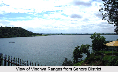
 Sehore district stands in the foothills of Vindhyachal Range in the middle of Malwa Plateau region. Sehore has a long and glorious past. "Sidhhapur" is the old name of Sehore. According to a rock- edict found from the river Seevan, it got its name from. On the other hands, a section of etymologist believe that Shehore derives its name from Sher, a word in Hindi, which means a lion, and a large number of lions were found in earlier times in the areas. "Sidrapur".
Sehore District
Sehore is a district of Madhya Pradesh in central India, which was also a part of Bhopal Estate.
Introduction
Sehore district stands in the foothills of Vindhyachal Range in the middle of Malwa Plateau region. Sehore has a long and glorious past. "Sidhhapur" is the old name of Sehore. According to a rock- edict found from the river Seevan, it got its name from. On the other hands, a section of etymologist believe that Shehore derives its name from Sher, a word in Hindi, which means a lion, and a large number of lions were found in earlier times in the areas. "Sidrapur".History of Sehore District
Sehore District has a long and glorious past. The Shaiva, Shakta, Jain, Vaishnava, Buddhists and Nath priests made Sehore a significant seat of their deep meditation. After formation of Madhya Pradesh, the state capital Bhopal was a part of the Sehore district. It was bifurcated in 1972 and a new district Bhopal was formed. Sehore has been an integral part of Avanti. Later on it was under the tutelage of Magadhan dynasty, Chandragupta I, Harshavardhana, Ashoka the great, Raja Bhoj, Peshwa chiefs, Rani Kamlawati and the Nawabs of Bhopal dynasty. Sehore remained the headquarters of the political agents and residents of the British East India Company.
Sehore played a crucial role in Sepoy mutiny 1857. "Nishan-e- Mahaviri and Nishan -e- Mohammadi" remained furling in the place of Union Jack. That short phase of independence from the British clutches ended, when Sir Hurose and Robert Hamilton crushed the uprising by putting 354 patriots to the gallows and gunning down 149 sepoys. Nawabs of Bhopal became always loyal to the British. That caused heavily to the efforts of the patriots in order to flush out the British from Sehore. But, the estate of Bhopal did not merge with the India state after the independence in 1947. Sehore has the honour of its achievement in the field of academics and literature.
 History of Sehore district is filled with rich glories of the past. This district in the state of Madhya Pradesh stands in the foothills of Vindhyachal range in the middle of Malwa Plateau region. The priests of different sects like Shaiva, Jain, Shakta, Vaishnavas, Buddhist and Nath made the Sehore district a significant seat of their deep meditation. This district was previously a part of the Bhopal estate. After the formation of the state of Madhya Pradesh, the state capital Bhopal was a part of the Sehore district. It was bifurcated in the year 1972, and a new Bhopal district was formed.
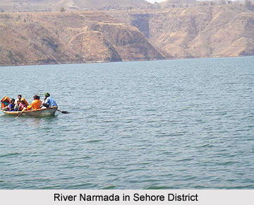
Several big and small rivers abound the landscape of the Sehore district. Narmada River, Parbati River, River Dudhi, River Newaj, River Kolar, River Papnas, River Kulans, River Seewan, River Lotia, and other rivers tell the sad tale of their lost splendour in the form of scattered idols. Idols of Lord Vishnu, Lord Ganesha, Lord Shiva, Goddess Parvati, Nandi, Garuda, Lord Mahavira, Gautama Buddha, apsaras and fairies have been found in different postures and forms.
Maharshi Patanjali, the illustrious founder of Yoga sect spent some time here in prayers and worship. Folklore also indicates to the visits of Lord Rama, Lakshmana and Sita to its different places. Sehore has a number of temples, monasteries, shrines, mosques and churches of great historical and religious antiquity. In that sense, the district of Sehore boasts of its glorious tradition of communal harmony and homogeneous culture.
"Sidhhapur" is the old name of the Sehore district. As per the rock- edict found from the River Seevan, it got its name from `Sidrapur". The district of Sehore got its name from the Anglo-Indian perversion of "Sher" or Lion as pronounced by the British, since lion or `Shers` were in great numbers in the nearby jungles. This district has been an integral part of Avanti. Later on, it was under the rule of Magadha dynasty, Chandragupta I, Harshavardhan, Ashoka the great, Raja Bhoj, Peshwa chiefs, Rani Kamlawati and the Nawabs of Bhopal dynasty. This district in the state of Madhya Pradesh remained the headquarters of the British people.
The district of Sehore played a vital role in the freedom movement of India, especially the Sepoy Mutiny 1857. `Nishan-e-Mahaviri` and `Nishan-e-Mohammadi` remained furling in the place of Union Jack. That short phase of independence from the British clutches ended, when Sir Hurose and Robert Hamilton crushed the uprising by putting three hundred and fifty four patriots to the gallows and gunning down one hundred and forty nine Indian military men worked under British East India Company (sepoys). Nawabs of Bhopal remained always loyal to the British and that caused heavily to the efforts of the patriots in order to move out the British from the district of Sehore.
On the 15th of August 1947, India got its independence, but the estate of Bhopal did not merge with the Indian Union till 1949. Sehore has the honour of its achievement in the field of literature and academics. Lanciet Likinson, a British politician got translated Kalidasa`s famous book "Abhignan Shakuntalam" in 1835-40.
Sehore played a crucial role in Sepoy mutiny 1857. "Nishan-e- Mahaviri and Nishan -e- Mohammadi" remained furling in the place of Union Jack. That short phase of independence from the British clutches ended, when Sir Hurose and Robert Hamilton crushed the uprising by putting 354 patriots to the gallows and gunning down 149 sepoys. Nawabs of Bhopal became always loyal to the British. That caused heavily to the efforts of the patriots in order to flush out the British from Sehore. But, the estate of Bhopal did not merge with the India state after the independence in 1947. Sehore has the honour of its achievement in the field of academics and literature.
History of Sehore district is filled with rich glories of the past. This district in the state of Madhya Pradesh stands in the foothills of Vindhyachal range in the middle of Malwa Plateau region. The priests of different sects like Shaiva, Jain, Shakta, Vaishnavas, Buddhist and Nath made the Sehore district a significant seat of their deep meditation. This district was previously a part of the Bhopal estate. After the formation of the state of Madhya Pradesh, the state capital Bhopal was a part of the Sehore district. It was bifurcated in the year 1972, and a new Bhopal district was formed.
Several big and small rivers abound the landscape of the Sehore district. Narmada River, Parbati River, River Dudhi, River Newaj, River Kolar, River Papnas, River Kulans, River Seewan, River Lotia, and other rivers tell the sad tale of their lost splendour in the form of scattered idols. Idols of Lord Vishnu, Lord Ganesha, Lord Shiva, Goddess Parvati, Nandi, Garuda, Lord Mahavira, Gautama Buddha, apsaras and fairies have been found in different postures and forms.
Maharshi Patanjali, the illustrious founder of Yoga sect spent some time here in prayers and worship. Folklore also indicates to the visits of Lord Rama, Lakshmana and Sita to its different places. Sehore has a number of temples, monasteries, shrines, mosques and churches of great historical and religious antiquity. In that sense, the district of Sehore boasts of its glorious tradition of communal harmony and homogeneous culture.
"Sidhhapur" is the old name of the Sehore district. As per the rock- edict found from the River Seevan, it got its name from `Sidrapur". The district of Sehore got its name from the Anglo-Indian perversion of "Sher" or Lion as pronounced by the British, since lion or `Shers` were in great numbers in the nearby jungles. This district has been an integral part of Avanti. Later on, it was under the rule of Magadha dynasty, Chandragupta I, Harshavardhan, Ashoka the great, Raja Bhoj, Peshwa chiefs, Rani Kamlawati and the Nawabs of Bhopal dynasty. This district in the state of Madhya Pradesh remained the headquarters of the British people.
The district of Sehore played a vital role in the freedom movement of India, especially the Sepoy Mutiny 1857. `Nishan-e-Mahaviri` and `Nishan-e-Mohammadi` remained furling in the place of Union Jack. That short phase of independence from the British clutches ended, when Sir Hurose and Robert Hamilton crushed the uprising by putting three hundred and fifty four patriots to the gallows and gunning down one hundred and forty nine Indian military men worked under British East India Company (sepoys). Nawabs of Bhopal remained always loyal to the British and that caused heavily to the efforts of the patriots in order to move out the British from the district of Sehore.
On the 15th of August 1947, India got its independence, but the estate of Bhopal did not merge with the Indian Union till 1949. Sehore has the honour of its achievement in the field of literature and academics. Lanciet Likinson, a British politician got translated Kalidasa`s famous book "Abhignan Shakuntalam" in 1835-40.
Geography of Sehore District
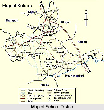
Sehore District is bounded by six districts; these are Bhopal, Raisen district, Hussainabad, Dewas District, Shajapur District and Rajgarh District. Sehore District extends between the parallels of Latitude 22 degree and 31 minutes to 23 degree and 40 minutes north and between the meridians of Longitude 76 degree and 22 minutes and 78 degree and 08 minutes east. Its height from the sea level is 1500 ft. to 2000 ft. It covers the total area of 6578 Kilometres. Narmada River, Parbati River, Dudhi River, Newaj River, Kolar River, Papnas River, Kulans River, Seewan River and Lotia River are the rivers flowing in Sehore district. Sehore district has divided into five Tehsils. They are Sehore, Ashta, Ichhawar, Budni, and Nasrullahganj.
 Geography of Sehore district covers an area of about six thousand five hundred and seventy eight square kilometres. The Sehore district in the Madhya Pradesh state stands in the foothills of Vindhyachal Range in the middle of Malwa Plateau Region. The district of Sehore is thirty-nine kilometres away from the capital city of Bhopal towards south on Bhopal-Indore highway.
The Sehore district is located at an altitude of fifteen hundred feet to two thousand feet above the level of sea. This district in the state of Madhya Pradesh is also connected to the Western Railway from Bhopal to Ratlam. The district of Sehore is positioned in between twenty two degree thirty one minutes and twenty three degree forty minutes to the North latitude and seventy six degree twenty two minutes and seventy eight degree eight minutes to the East longitude.
The Sehore district is having its borders with six different districts, which include the Dewas District, Bhopal district, Raisen district, Shajapur district, Rajgarh district and the Hoshangabad district. The area covered by this district in the state of Madhya Pradesh in India is six thousand five hundred and seventy eight square kilometres.
The average rainfall received by this district is 1261.1 millimetre, while the average minimum temperature is 7.9 degree Celsius and the average maximum temperature is 42.4 degree Celsius. The total area of this district covered by forest is 1, 72,554 hectares and the net irrigated area is 1, 14,041 hectares and the gross cropped area in this district is 4,55,3 hectares. The total area of the district put to non-agricultural uses is 42,773 hectares and the gross cropped area of the district of Sehore is 4,55,3 hectares.
For drinking water, there are hand pumps in nine hundred and ninety four villages and tap water in seventy villages in the district of Sehore in the state of Madhya Pradesh. There are several big and small rivers, which flow through the district of Sehore, and some of them are Narmada River, Ajnal River, Parvati River, Kolar River, Seep River, Utawali River, Amber River, Dudhi River, Seewan River, Nevaj River, Kaliasot River, etc.
Geography of Sehore district covers an area of about six thousand five hundred and seventy eight square kilometres. The Sehore district in the Madhya Pradesh state stands in the foothills of Vindhyachal Range in the middle of Malwa Plateau Region. The district of Sehore is thirty-nine kilometres away from the capital city of Bhopal towards south on Bhopal-Indore highway.
The Sehore district is located at an altitude of fifteen hundred feet to two thousand feet above the level of sea. This district in the state of Madhya Pradesh is also connected to the Western Railway from Bhopal to Ratlam. The district of Sehore is positioned in between twenty two degree thirty one minutes and twenty three degree forty minutes to the North latitude and seventy six degree twenty two minutes and seventy eight degree eight minutes to the East longitude.
The Sehore district is having its borders with six different districts, which include the Dewas District, Bhopal district, Raisen district, Shajapur district, Rajgarh district and the Hoshangabad district. The area covered by this district in the state of Madhya Pradesh in India is six thousand five hundred and seventy eight square kilometres.
The average rainfall received by this district is 1261.1 millimetre, while the average minimum temperature is 7.9 degree Celsius and the average maximum temperature is 42.4 degree Celsius. The total area of this district covered by forest is 1, 72,554 hectares and the net irrigated area is 1, 14,041 hectares and the gross cropped area in this district is 4,55,3 hectares. The total area of the district put to non-agricultural uses is 42,773 hectares and the gross cropped area of the district of Sehore is 4,55,3 hectares.
For drinking water, there are hand pumps in nine hundred and ninety four villages and tap water in seventy villages in the district of Sehore in the state of Madhya Pradesh. There are several big and small rivers, which flow through the district of Sehore, and some of them are Narmada River, Ajnal River, Parvati River, Kolar River, Seep River, Utawali River, Amber River, Dudhi River, Seewan River, Nevaj River, Kaliasot River, etc.
Demography of Sehore District
According to the Population Census in 2011, Sehore district had a population of 1,311,008. Out of which the male and female were 683,703 and 627,305 respectively. The population of Sehore District constituted 1.81 percent of total Madhya Pradesh population.
Education of Sehore District
In education sector, Sehore district is well named in the state of Madhya Pradesh. The average literacy rate of Sehore district in 2011 was 71.11 percent. The male and female literacy rate was 82.37 and 58.86 percent respectively. The total literates in Sehore District were 793,710 of which male and female were 479,009 and 314,701 respectively.
There are several schools and colleges in Sehore District. They are as follows:
Post Graduate College, R.A.K Agri Sehore College, Government Girls College, Satya Sai Engineering College, Government Engineering College of Ichhawar , Government Engineering College of Nashrullahganj, Government Engineering College of Ashta, Government Women Polytechnic College and ITI Sehore
Post Graduate College, R.A.K Agri Sehore College, Government Girls College, Satya Sai Engineering College, Government Engineering College of Ichhawar , Government Engineering College of Nashrullahganj, Government Engineering College of Ashta, Government Women Polytechnic College and ITI Sehore
Economy of Sehore District
Sehore District is mainly an agricultural district. Sehore is having more than 80 percent soyabean cultivation area of the district. The district has few trade and industries as Krashi Upaj Mandi, Bhopal Sugar Industries, Oil Fed Industries, Jag Manak Refinery Plant, and Pasu Ahar Sayantra.
Tourism in Sehore District
 Tourism in Sehore district offers several options including a number of temples, churches, Gurudwara, mosques and many others. One of the most prominent temples in the district of Sehore in the state of Madhya Pradesh is a Ganesh Mandir known as the Sidhha Ganesha Mandir (Siddha Ganapati Temple). The temple was erected in the Gopalpur village in the North-West direction, about three kilometres from the district Headquarters. According to the legend, this temple dates back to Vikramaditya of Ujjain and later the Maratha Peshwa, Baji Rao I, renovated it. Every Wednesday, a large numbers of devotees throng this temple. The Ganesha Chaturthi festival is a popular festival celebrated in this temple in Sehore district.
The Hanuman Phatak is an emphatic temple dedicated to Lord Hanuman on a Garhi . It is placed on the bank of Seewan River in a far-flung corner, offers an aesthetic ambience as well as a prominent seat of devotion. The Navratri festival in Ashwin and Chaitra are among the most popular festivals celebrated in this temple. The Ramlala Mandir is also of great importance, which is located at a distance of one kilometre from Sehore in Badia Khedi. This temple is revered amongst eighty-four Hindu monasteries of India. Another temple of religious importance in the district of Sehore in Madhya Pradesh is the Salkanpur Durga Temple. This temple is situated on an eight hundred feet high hillock, in the village called Salkanpur. It is seventy kilometres from Bhopal. The temple is dedicated to Goddess Durga and the deity, Ma Durga Beejasan is held in great esteem by her followers and local people.
 Apart from the Hindu temples, there are also places of religious importance for people of other faiths. The Gurudwara is in the Ganga Ashram at Sehore. Sikh Militarymen renovated the Gurudwara in the year 1936; it holds the Langer and Path of Guru Nanak Saheb. There is also a Jain Mandir in Sehore, which attracts pilgrims from various parts of the state. It is located in Kasba (Sehore). Two Tirthankara idols are there in the monasteries dated 1335 and 1548. The year between 1335 to 1584 is known as Vikram Samvat Era. The calendar made by the Indian Emperor Vikramaditya is called Vikram Samvat.
Cenotaphs and tombs of Kunwar Chain Singh are located in Dashahra wala Maidan on the bank of Lotia River on the Sehore-Indore Road. Jama Masjid was constructed by Mugis Uddin Shah in 732 Hijri and was renovated by Beghum Siknadar Jahan in 1281. This mosque is said to once posses a picturesque Bawadi or a water tank.
A British political leader who belonged to Scotland in the year 1838 erected the Sehore Church. The Church building is an exact replica of a church in Scotland and even the surrounding greenery, possessing mainly tall bamboo trees, was designed to match the original. To traverse the Sehore soil is to tread upon centuries of colourful history. The most convenient time to visit the Sehore district and its sprawling teak forests is in the month of November with its autumn ripeness and in the month of March with its spring finery.
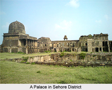
Other attractions of the district of Sehore include the Saru-Maru caves, the Higher Secondary School at Sehore, etc. Caves, rock edicts and stupas on Hoshangabad District road belonging to the Saru-Maru caves is said to be visited by Ashoka, his son Mahendra and his daughter Sanghamitta. This place forms one of the most prominent tourist attractions in the Sehore district. There is a Higher Secondary School in Sehore and the building of which is very old. This is one of the four Vernacular schools opened by the British in this district. This school boasts up with alumni like Sir Hidayatullah and Justice Wanchoo. The Nizamat building where the Nizam of the erstwhile Bhopal state held court is also worth a visit for the visiting tourists.
There are many tourist spots in Sehore. These tourist spots have both historical and religious aspects. These are as follows:
Sidhha Ganesh Mandir
Sidhha Ganesh Mandir is established in the village of Gopalpur in the North West direction, 3 kilometres from the District Headquarters. As per legend, it dates back to King Vikramaditya of Ujjain and renovated by Baji Rao I, the Maratha Peshwa. Each Wednesday, large number of devotees throngs here. Ganesha Chaturthi festival is also popular here.
Cenotaphs of Kunwar Chain Singh
Cenotaphs and tombs of Kunwar Chain Singh are 2 kilometres away in Dashahra wala Maidan on the bank of Lotia River on Sehore - Indore Road. These cenotaphs remind the historic fight between patriot Kunwar Chain Singh of Narsinghgarh (Princely State of Narsinghgarh) estate and the British general Medhank.
Jama Masjid
Mugis Uddin Shah built this mosque in 732 according to the Hijri Calendar and later renovated by Beghum Siknadar Jahan in 1281 builds Jama Masjid. It is said to posses once a picturesque Bawadi (water tank).
Jain Mandir
Jain temple is situated in Kasba of Sehore. Two Jain Tirthankaras idols are dated 1335 -1548.
Hanuman Phatak
An emphatic temple of Lord Hanuman on a Garhi on the bank of river Seewan in a far-flung corner of the city provides aesthetic ambience as well as a prominent seat of devotion. Navratri festival in Ashwin and Chaitra are very popular for its religious importance.
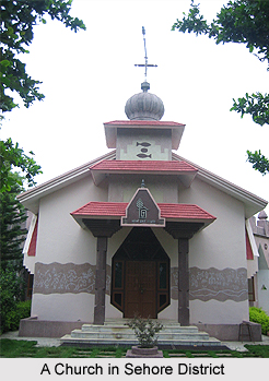
Sehore Church
A British political leader, who belonged to Scotland in 1838, built the Sehore Church. The building is an exact replica of a church in Scotland and even the surrounding greenery, comprising mainly tall Bamboo trees, was designed to match the original .To traverse the Sehore soil is to tread upon centuries of colourful history.
Gurudwara
Gurudwara is in Ganga Ashram, Sehore and it renovated in 1936 by Sikh Military men, it holds Langer & Path of Guru Nanak Saheb.
Ramlala Mandir
Ramlala Mandir is situated 1 Km from Sehore in Badia Khedi, it is revered amongst 84 Hindu monasteries of India.
Salkanpur Durga Temple
Salkanpur Durga Temple is situated on 800 Feet high hillock, in the village Salkanpur, 70 Kms from Bhopal. The deity, Goddess Durga Beejasan is held in high esteem by her followers and the local people.
Saru-Maru Cave
Saru-Maru cave is the place full of caves, rock edicts and stupas on Hussainabad road; the greatest ruler of Maurya Empire, Ashoka, his son Mahendra & daughter Sanghamitta visited this place
Recently updated articles in States of India

History of Thissur District
Early History of Thissur District explains flourishing of the port cities. Now these port cities are transformed into archaeological sites.

Tippi Orchid Research Centre, Arunachal Pradesh
Tippi Orchid Research Centre in Arunachal Pradesh is renowned for its rich collection of exotic and endangered orchids. Surrounded by lush rainforest...

Tourism in Nashik District
Pilgrimage tourism in Nashik district involves visiting the various places of Hindu and Jain worship located here. Some of the holiest sites for Hind...

Mangadu, Kerala
Mangadu in Kerala’s Kollam district is a significant megalithic site known for its urn burials, cist burials, menhirs, and stone circles. Excavations...

Devaswom
History of Devaswom is not very ancient and can be dated back to late seventeenth century.
Related articles in States of India

East Indian States
East Indian States comprises of Bihar, Jharkhand, West Bengal, Odisha and also the Union Territory of Andaman and Nicobar Islands. It defines the cult...

Purnia District in Bihar
Purnia District is located in Bihar and extends from River Ganga to Nepal. The district has a rich Hindu history and glorious past.

Hooghly district
Hooghly District along the bank of the river Hooghly is one of the principal trading ports of West Bengal.

Geography Of Chittoor District
Geography of Chittoor district is spread along the topography of the land which is divided into two natural divisions; Chittoor has a dry and healthy...

Districts of West Bihar
Districts of West Bihar is comprised of medieval monuments that were built by the different governors of Mughal era.