 Geography of Princely State of Jammu and Kashmir came in the limelight when the British came in the power.
Location of Princely State of Jammu and Kashmir
Geography of Princely State of Jammu and Kashmir was extended from 32 degree 17 minutes to 36 degree 58 minutes North and from 73 degree 26 minutes to 80 degree 30 minutes East.
Extension of Princely State of Jammu and Kashmir
Princely State of Jammu and Kashmir was the southernmost part of the state and was adjacent to the Punjab districts of Jhelum, Gujarat, Sialkot and Gurdaspur. There is a fringe of level land along the Punjab frontier, bordered by a plinth of low hilly country sparsely wooded, broken, and irregular. This is known as the Kandi, the home of the Chibs and the Dogras. To travel north, a range of mountains 8,000 feet (2,400 m) high must be climbed.
Environment of Princely State of Jammu and Kashmir
Princely State of Jammu and Kashmir was covered with forests of oak, rhododendron, chestnut, and higher up, of deodar and pine, a country of uplands, such as Bhadarwah and Kishtwar, drained by the deep gorge of the Chenab river.
Mapping of Princely State of Jammu and Kashmir
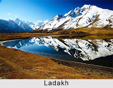
Princely State of Jammu and Kashmir was mapped by the British government Steeper parts of the Himalayas lead to Astore and Baltistan on the north and to Ladakh on the east, a tract drained by the river Indus. To the northwest, lies Gilgit, west and north of the Indus. The whole area is shadowed by a wall of giant mountains that run east from the Kilik or Mintaka passes of the Hindu Kush, leading to the Pamir Knot and the Chinese dominions past Rakaposhi (25,561 ft), along the Muztagh range past K2 (Godwin-Austen Glacier, 28,265 feet), Gasherbrum and Masherbrum (28,100 and 28,561 feet (8,705 m) respectively) to the Karakoram range which merges in the Kunlun Mountains. Westward of the northern angle above Hunza and Nagar, the maze of mountains and glaciers trends a little south of east along the Hindu Kush range bordering Chitral and so on into the limits of Kafiristan and Afghan territory.
Related Articles
Modern History of India
British Empire in India
Princely States of India
Princely State of Jammu and Kashmir
Jammu and Kashmir
British East India Company