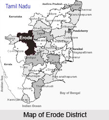
 Erode district is situated on the extreme northern portions in the state of Tamil Nadu. It is having its borders as the state of Karnataka and the Palar River covers pretty long distance. The district of Erode is bounded by Namakkal, Karur, Dindigal, Coimbatore and Nilgiri districts. This district is mainly a land-locked area having no sea-cost of its own. The region comprised in the district can be depicted as a long undulating plain mildly sloping towards the Kaveri River in the south-east. The three major tributaries of the Kaveri River viz. Noyyal, Bhavani and Amaravathy drain the long stretch of mountains in the north. A portion of the eastern boundary of this district is formed by Kaveri River, entering the district from Salem and flowing in the southern direction.
Erode District
Erode District is one of the districts in the state of Tamil Nadu. The district of Erode is having a land-locked area with no sea coast.
Introduction
Erode district is situated on the extreme northern portions in the state of Tamil Nadu. It is having its borders as the state of Karnataka and the Palar River covers pretty long distance. The district of Erode is bounded by Namakkal, Karur, Dindigal, Coimbatore and Nilgiri districts. This district is mainly a land-locked area having no sea-cost of its own. The region comprised in the district can be depicted as a long undulating plain mildly sloping towards the Kaveri River in the south-east. The three major tributaries of the Kaveri River viz. Noyyal, Bhavani and Amaravathy drain the long stretch of mountains in the north. A portion of the eastern boundary of this district is formed by Kaveri River, entering the district from Salem and flowing in the southern direction.History of Erode District
 History of Erode district is integrally related to that of the Coimbatore. Erode district came into being as a result of the bifurcation of Coimbatore district, through the G.O.Ms.No.1917, Revenue dated 31st August 1979. It is very difficult to deal separately with the history of Erode region from that of Coimbatore. Together with the area comprised in the Coimbatore district, it formed part of the ancient Kongu country known as `Kongu Nadu`, the history of which dates back to the Sangam era. It is found that in the early days, the area was occupied by tribes, most prominent among them being the `Kosars` having their headquarters at `Kosamputhur` which is believed to have in due course become Coimbatore. These tribes were overpowered by the Rashtrakutas from whom the region fell into the hands of the Cholas who ruled supreme during the time of Raja Chola.
After the decline of Cholas, the Kongunadu came to be occupied by the Chalukyas and later by the Pandyas and the Hoysalas. Due to internal dissension in the Pandian Kingdom, the Muslim rulers from Delhi got a chance to interfere and thus the area fell into the hands of Madurai Sultanate. This region was later wrested by Vijaya Nagar rulers after overthrowing the Madurai Sultanate. For a few years, the area remained under the rule of the Vijaya Nagar kings and later under the independent control of Madurai Nayakas.
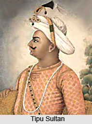
The rule of Muthu Veerappa Nayak and later the rule of Tirumalai Nayak of Madurai were marked by internal strife and intermittent wars which ruined the Kingdom. As a result of this, the Kongu region in which the present Erode district is located fell into the hands of the Mysore rulers from whom Hyder Ali took over the reign. Later, consequent of the fall of Tipu Sultan of Mysore in the year 1799, the Kongu region came to be coded to the British East India Company by the Maharaja of Mysore who was restored to power by the company after defeating Tipu Sultan. From then, till they year 1947, when India attained independence, the area remained under British control who initiated systematic revenue administration in the area.
Geography of Erode District
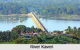 Geography of Erode district is such that it is surrounded by land from all sides and does not have a sea coast of its own. Erode district lies on the extreme north of the state of Tamil Nadu. It is bounded mostly by Karnataka State and also River Palar covers pretty long distance. To the East of this district lies Namakkal and Karur Districts. Dindigal district is its immediate neighbour to the South and on the West; it has Coimbatore and Nilgiri districts, as its boundaries. The region of this district can be portrayed as a long undulating plain gently sloping towards the river Kaveri in the south-east. The three major tributaries of river Kaveri are Bhavani, Noyyal and Amaravathy which drain the long stretch of mountains in the north. A part of the eastern boundary of the district is formed by river Kaveri, entering the district from Salem and flowing in the southern direction.
Climate of Erode District : Erode in general is characterized with a scanty rainfall and a dry climate. Maximum rainfall is recorded in Gobichettipalayam and Bhavani taluks. The Palghat gap in the Western Ghats, which has a soothing effect in the climate of Coimbatore district, does not render much help in bringing down the dry climate in this area. The cool-wind that gushes out of the west coast through Palghat gap looses its coolness and becomes dry by the time it crosses Coimbatore district and reaches the regions of Erode district. Unlike Coimbatore which is blessed with a health-aiding climate, Erode district experiences dry weather throughout, except during the monsoon season. Generally, the first two months of the year are pleasant, but in the month of March, the temperature becomes very high and it persists till the end of May. Highest temperature is normally recorded during the month of May. The scanty showers during this period do not provide any relief to the oppressive heat. There is a light improvement in the climate during the June-August period. During this pre-monsoon period, the mercury reverses its trend and by September, the sky gets overcast heavily but the rains are meager. North-east monsoon sets in vigorously only during October-November and by the month of December, the rains disappear rendering the climate clear but pleasant.
Soil in Erode District : Soil of Erode district is mainly red sand and gravel with moderate amounts of red-loam and occasional black loam tracts. Vast stretches of the upland regions are moist and gravelly. Red-loam occurs mostly in land under Kalingarayan channel and in beds of tanks in Erode taluk and to some lesser extent in the valleys in Perundurai and Dharapuram taluks. It also occurs in the hilly tracts of Bhavani taluk. Soils of Bhavani, Erode, Dharapuram and Perundurai taluks are chiefly gravelly, stony and sandy of the red variety. Soils of Gobichettipalayam and Sathyamangalam are mostly of the red sandy variety.
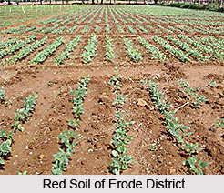 Red loam is prevalent mostly in Gobichettipalayam and Perundurai taluks. As per revenue land records, the total geographical area of the district is 816,191 hectares and out of this, 309,252 hectares have been brought under cultivation as net area sown. This accounts for 37.8 percent of the total area of the district.
Minerals of Erode District : Even if the Erode district cannot boost of great mineral wealth, it still has a few varied items of significance. Opaque and translucent varieties of fine quality of Feldspar are found abundantly in Erode taluk. Mica and Muscovite occur in Vairamangalam near Bhavani and near Punjai Puliampatti respectively. Asbestos is available in a few places of Bhavani and Perundurai. Doddan Combai forest in Gobichettipalayam is rich in iron ore. This ore is of the best quality and rich in metal. Traces of gold also have been found in a few auriferous veins in Gobichettipalayam.
Some of the prominent rivers of this district are Bhavani, Amaravathy and Noyyal and the Kaveri River. Other significant rivers are Palar in the north, Vatamalaikarai odai and Uppar Rivers in the south. Palar constitutes the boundary between Erode district and the state of Karnataka in the north. The Bhavanisagar main canal along with the above mentioned rivers provide proper drainage and facilities for proper irrigation in the district. The Bhavanisagar main canal rises in the silent valley in Palghat ranges in the neighbouring State of Kerala after receiving Siruvani, a perennial stream of Coimbatore district and gets reinforced by the Kundah River before entering Erode district in Gobichettipalayam.
Administration of Erode District
The district of Erode is having the collector as the head of the district. The district collector is assisted by a number of subordinate officers in his general work of administration. Erode district comprises of 7 taluks which are Bhavani, Sathyamangalam, Erode, Gobichettipalayam, Perundurai, Kangayam and Dharapuram. There are 5 municipalities in the district which include Sathyamangalam, Gobichettipalayam, Erode, Bhavani and Dharapuram. There are 59 town panchayats and 3 village panchayats declared as Census Town as per Census 2001 and 539 revenue villages. Apart from these, there are 20 Community Development Blocks in the district.
Education in Erode District
 In the field of education, this district has recorded remarkable achievement. There are a number of well-developed schools and colleges preparing students for the usual degree and post-graduate degree courses in various branches of humanities and science. The Mahajana College of Erode was the pioneer in the field of higher education in the district. Apart from these institutions, there are a number of Polytechnic and other institutions which provide technical education.
Erode Arts College : With a humble start as an aided 1st Grade College, Erode Art College (Autonomous) was affiliated to University of Madras. At that time students could take admission to Pre University Course and B.A. in Economics only. With the formation of Bharathiar University, the College received its affiliation from the said university in 1982. In 1987 Erode Arts College gained autonomous status. NAAC has bestowed B++ status on the college. It is situated at 205, Chennimalai Road, Rangampalayam, Erode - 638009. B.A. in Economics, B.Com in (C.S) Corporate Secretaryship, B.Sc in Mathematics, B.Sc in Physics, B.Sc in Chemistry, B.Sc. in Animal Science and Biotechnology, B.Sc in Computer Science, B.Sc in Electronics, B.Com, B.B.M (Bachelor of Business Management) are some of the undergraduate courses offered. Some of the unaided courses include- B.C.A (Bachelor of Computer Applications), B.A in English Literature. Mathematics and Computer Science, Physics, Chemistry, Zoology, Electronics, Economics, Corporate Secretary, Commerce, Business Management, History, Botany, Physical Education are the departments of Erode Art College that are well served by a team of dedicated, experienced and qualified faculty members.
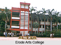 The college has a well-equipped library, which remains open from 8.30 a.m. to 5.30 p.m., on all days of the week. It is wholly computerised. The library stocks periodicals and books on various subjects. The Erode Arts College Hostel encircles an area of 31,986 sq. ft and comprises forty-three rooms. At a time it can accommodate two hundred and forty students. Hostellers can get facilities, including extensive playground, telephone with ITC Card facility, recreation room with a TV set, reading room, computer facility, indoor game facility, recent cooking facility, pure drinking water arrangement, counseling provided by an experienced faculty. Special provision also is available for physically challenged students, so that they can travel from their rooms on a wheel chair. The Hostel mess that runs on dividing system, supplies healthy vegetarian and non-vegetarian meals.
A Placement Cell has been established with the motive to provide information on job opportunities for students and also helps them to find employment in renowned companies and organisations. The Erode Arts College Alumni Association was formed on April 27, 2002. About 1450 students are members of the association. Currently 34 Alumni are working as teaching and non-teaching staff members in the college.
Economy of Erode District
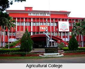 Economy of Erode district is depended on its trade and industry. However the district is also advanced in the field of agriculture. Close association and link with Coimbatore district which has the advantage of two premier agricultural Institutions like the Agricultural College and the Research Institute have helped the farmers of this district to keep abreast of developments in agricultural methods and practices and also improved strains of seeds. The publicity and developmental activities launched by the agricultural institutions in Coimbatore penetrated far and wide in the district of Erode. Irrigation facilities coupled with the awareness of improved methods of farming helped the agriculturists to forge ahead. Though the soil so good, utilization of improved methods of cultivation and improved strains of seeds have helped the agriculturists in the district to maximize their output.
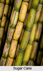
Paddy is grown over eighty six thousand nine hundred and thirty nine hectares. After paddy, Cholam is raised in more than eleven thousand two hundred and forty hectares. Pulses are not cultivated here in large scale and thirty one thousand four hundred and ninety eight hectares of land are used for raising pulses. Among condiments and spices, turmeric and chillies are prominent. Cultivation of turmeric extends over forty one thousand five hundred and thirty three hectares. Among the non food crops, oil seeds cover the most parts with 55.23 percent of the total area under non food crops in this district. A total of ninety five thousand and eighteen hectares are under oil-seeds cultivation and of these, ground-nuts account for fifty five thousand six hundred and ninety six hectares while gingerly accounts for twenty four thousand eighty four hectares. Ground-nut is the most popular oil-seed raised in this district. Among other non-food crops raised here, the most important items are cotton, sugarcane and tobacco. Sugarcane is raised in thirty thousand nine hundred and three hectares. Cotton is grown in few hectares while tobacco is raised in four thousand nine hundred and twenty three hectares in this district.
Fisheries in Erode District : In this district, inland fisheries are the only resource for fishermen which also contribute to the district`s economy. As a landlocked district, there are no options for marine fishing and hence the opportunities for fishing are restricted. With the aid of the Fisheries Department, rapid strides have been made in the development of fisheries in the Erode district. Special emphasis is laid on the formation of fishermen`s co-operatives and familiarizing the local fishermen with the improved methods. With the help of the co-operative organization which assured deep involvement of the fishermen, a number of co-operative organizations have been formed.
Animal Husbandry in Erode District :
 The district of Erode in the state of Tamil Nadu is rich in its natural cattle wealth and concerted efforts of the Animal Husbandry Department have further augmented the cattle wealth. There are four major breeds of cattle in this district. They are the Kangayam breed, the Burgur breed, the Kollegal variety and the Alanbodies. Kangayam breed of cattle is indigenous to Coimbatore. With varieties of breeds available, the district has made a fast progress in the field of animal husbandry. Erode has acquired an enviable position for itself in the field of dairy development industry in the state. The Tamil Nadu Milk Producers Federation possesses a milk collection center and processing plant at the Erode district from where pasteurized milk is transported in cases to various parts of the state daily.
Trade and Industry in Erode District : Erode district holds a notable place in the industrial map of Tamil Nadu with 40.32 percent of population depending on non-agricultural sector. Trade and industry occupy a prominent place in the economy of this district. Industries that flourished in early days in the area were handloom weaving, cart manufacturing, carpet manufacturing, brass vessel manufacturing, oil-pressing, etc. The advent of modern times changed the fate of some of these well established ancient industries. Dharapuram, which was known for the manufacture of load carrying and passenger carts lost its importance after the advent of modern means of transport of two wheelers like cycle, scooter, moped etc. However, the industry still survives at Dharapuram and load carrying carts are still manufactured. Handloom industry in Erode district has encouraged the growth of several ancillary industries to meet the needs of the textile mills. Chennimalai, Erode, Gobichettipalayam etc., are the prominent centers where cotton ginning done on a large scale. There are several major dying works in Erode, Chennimalai and Bhavani. A number of factories engaged in cotton fabric printing are also functioning in Erode.
Rice milling is another industry which exists in the Erode district. Erode, Bhavani, Perundurai, Dharapuram and Kangayam are centers where a number of rice mills are flourishing. There are several leather tanneries in Erode and Dharapuram area. Huge amount of leather are brought here for tanning and later those are exported to foreign countries. Both manufactured items as well as agriculture commodities are included in the trade items. Major items of export from the Erode district are handloom products, raw cotton, dairy products, rice etc and the items brought are mostly oil-seeds, coal etc.
Tourism of Erode District
The district of Erode is a suitable tourist destination in the state of Tamil Nadu in India. The temples in Erode district are the major attractions in the entire state. There are nearly 487 temples in this district. These temples are located in four taluks; Erode, Gobichettipalayam, Dharapuram and Bhavani. Out of the 207 places recognized as Padal Petra Sthalam, there are two temples found in Erode District viz., Bhavani and Kodumudi. There is one Jain Temple at Vijayamangalam which is 25 kilometers from Erode. The temple was constructed by Jain King Konguvelir some 1,800 years back. Towards the construction of temples in the district of Erode popularly known as Kongunad, Hoysalas, Cholas and Pandyas have contributed their mite. Some of the other well-known temples in this district are Veerakumarasami temple, Natturayaswami temple, Bhagavan temple, etc. Even if Lord Muruga is worshipped in the Veeramumaraswami temple, no woman is permitted to enter the temple and worship the God there. The Bhagavan temple at Ponnivadi is well-known to cure epidemics like cholera, plague and smallpox.
The district of Erode in the state of Tamil Nadu is a very important market centre for turmeric. Turmeric is received, not only from the Erode district, but also from other parts of Tamil Nadu and adjoining Mysore district in the state of Karnataka. Erode is very famous for marketing of textile products of Power loom, Handloom and readymade garments. The Power loom and Handloom products like cotton sarees, bed spreads, carpets, lungi, printed fabrics, towels, dhoti, etc are marketed in this district in bulk.
Bannari Mariamman Koil of Erode
This temple is situated on the western side of Erode and is about 10 kms from Bhavani Sagar. The Goddess Mariamman here is very famous and attracts thousands of devotees. The annual festival of this temple is held in the month of Adi (August-September) and large numbers of people come here during this time. The fire walk by the devotees is very thrilling here.
Bhavani town of Erode
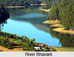
Bhavani town is situated at the convergence of the river Cauvery. Bhavani is one of its major tributaries. At this convergence, the Sangameswarar temple is situated. It is also known as the `Thriveni of South India`. This is one of the pilgrim centres of Erode and is also a significant picnic centre. Here, Lord Sangameswara with his spouse Vedanayaki is the presiding deity.
There is an ivory cradle in this temple of Erode, which is said to be presented by William Garraw, collector of the Coimbatore and Salem districts of the colonial period. As per the legends, it is said that once he was directed by the Goddess Vedanayaki to immediately vacate the building in which he was staying. He did so obeying the goddess and immediately after vacating, the building collapsed. So, he offered the ivory cradle to show his gratitude. It can be seen even today with the collector`s signature on it. The Bhavani Sagar Dam here is also visited by lots of pilgrims. One can also see a swimming pool and a park here. Bhavani is known the world over for its blankets with floral designs.
 Kodumudi temple of Erode
This is an important temple in Erode district. This place is situated 40 kms from Erode. The Trinity of the Hindu faith Siva, Vishnu and Brahma here is the unique feature of this temple. Their shrines can be found in a single temple complex here only. Here, the name of Siva is Muchukundeswarar and Veera Narayana Perumal is that of Vishnu.
Chennimalaj of Erode
This place is situated about 30 kms from Erode. Here, one can see a famous temple dedicated to Lord Muruga on the top of Chennimalai Mountain. Here, the rare forms of Muruga called `Agni Jather`, with two faces and eight arms and `Gourapeyar`, with four faces and eight arms, as hunter with a single face and six arms can be seen. Initially, the presiding deity had the idol of Subramanya with six faces. After it was damaged, a Dandayuthapani idol like the one at Palani has been installed as the presiding deity. It is an important handloom-weaving centre in Tamil Nadu.
Kangeyam of Erode
This temple is situated about 40 kms from Erode. A famous Muruga temple is located here. This place was once well known for bullocks called Kangeyam Kalai.
There is a modern Dhyana Mandapam, which is situated on the Muthur Road. This is situated about 10 kms from Erode and is called Kuttappalayam. This meditation hill was dedicated to Sri Aurobindo and the Mother of Pondicherry. This mandapam is located amidst a spacious 5 acre land which is being developed as a beautiful garden. The exact replica of the Sri Aurobindo and Mother samadhi found in Pondicherry can be seen inside the mandapam. Here, group meditation is conducted from 9.00 a.m. to 12.00 noon on every month on the 2nd Sunday. This attracts large number of people from far and near.
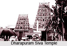 Dharapuram Siva Temple of Erode
Dharapuram is situated about 70 kms from Erode. There is an old Siva temple located here on the northern banks of river Amaravathi. The temple contains Lingam and Devi shrines. A separate shrine for Bhairava is also found here.
There is another Siva temple on the southern side, which is quite older than this one. It contains several inscriptions. The Dhakshinamurthi in the niche here is unlike the usual one. The idols of this temple are beautifully carved.
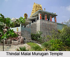
Some other important places of tourist attraction in Erode are the Thindal Malai Murugan temple, Pariyur Amman temple, Sivanmalai Arthra Kapaleeswarar temple, Kooduthurai, Kodiveri, Varattuppallam, Kunderippallam and the upper dams. All these places are interlinked by buses.
The district of Erode in the state of Tamil Nadu is a very important market centre for turmeric. Turmeric is received, not only from the Erode district, but also from other parts of Tamil Nadu and adjoining Mysore district in the state of Karnataka. Erode is very famous for marketing of textile products of Power loom, Handloom and readymade garments. The Power loom and Handloom products like cotton sarees, bed spreads, carpets, lungi, printed fabrics, towels, dhoti, etc are marketed in this district in bulk.
Bannari Mariamman Koil of Erode
This temple is situated on the western side of Erode and is about 10 kms from Bhavani Sagar. The Goddess Mariamman here is very famous and attracts thousands of devotees. The annual festival of this temple is held in the month of Adi (August-September) and large numbers of people come here during this time. The fire walk by the devotees is very thrilling here.
Bhavani town of Erode
Bhavani town is situated at the convergence of the river Cauvery. Bhavani is one of its major tributaries. At this convergence, the Sangameswarar temple is situated. It is also known as the `Thriveni of South India`. This is one of the pilgrim centres of Erode and is also a significant picnic centre. Here, Lord Sangameswara with his spouse Vedanayaki is the presiding deity.
There is an ivory cradle in this temple of Erode, which is said to be presented by William Garraw, collector of the Coimbatore and Salem districts of the colonial period. As per the legends, it is said that once he was directed by the Goddess Vedanayaki to immediately vacate the building in which he was staying. He did so obeying the goddess and immediately after vacating, the building collapsed. So, he offered the ivory cradle to show his gratitude. It can be seen even today with the collector`s signature on it. The Bhavani Sagar Dam here is also visited by lots of pilgrims. One can also see a swimming pool and a park here. Bhavani is known the world over for its blankets with floral designs.
Kodumudi temple of Erode
This is an important temple in Erode district. This place is situated 40 kms from Erode. The Trinity of the Hindu faith Siva, Vishnu and Brahma here is the unique feature of this temple. Their shrines can be found in a single temple complex here only. Here, the name of Siva is Muchukundeswarar and Veera Narayana Perumal is that of Vishnu.
Chennimalaj of Erode
This place is situated about 30 kms from Erode. Here, one can see a famous temple dedicated to Lord Muruga on the top of Chennimalai Mountain. Here, the rare forms of Muruga called `Agni Jather`, with two faces and eight arms and `Gourapeyar`, with four faces and eight arms, as hunter with a single face and six arms can be seen. Initially, the presiding deity had the idol of Subramanya with six faces. After it was damaged, a Dandayuthapani idol like the one at Palani has been installed as the presiding deity. It is an important handloom-weaving centre in Tamil Nadu.
Kangeyam of Erode
This temple is situated about 40 kms from Erode. A famous Muruga temple is located here. This place was once well known for bullocks called Kangeyam Kalai.
There is a modern Dhyana Mandapam, which is situated on the Muthur Road. This is situated about 10 kms from Erode and is called Kuttappalayam. This meditation hill was dedicated to Sri Aurobindo and the Mother of Pondicherry. This mandapam is located amidst a spacious 5 acre land which is being developed as a beautiful garden. The exact replica of the Sri Aurobindo and Mother samadhi found in Pondicherry can be seen inside the mandapam. Here, group meditation is conducted from 9.00 a.m. to 12.00 noon on every month on the 2nd Sunday. This attracts large number of people from far and near.
Dharapuram Siva Temple of Erode
Dharapuram is situated about 70 kms from Erode. There is an old Siva temple located here on the northern banks of river Amaravathi. The temple contains Lingam and Devi shrines. A separate shrine for Bhairava is also found here.
There is another Siva temple on the southern side, which is quite older than this one. It contains several inscriptions. The Dhakshinamurthi in the niche here is unlike the usual one. The idols of this temple are beautifully carved.
Some other important places of tourist attraction in Erode are the Thindal Malai Murugan temple, Pariyur Amman temple, Sivanmalai Arthra Kapaleeswarar temple, Kooduthurai, Kodiveri, Varattuppallam, Kunderippallam and the upper dams. All these places are interlinked by buses.
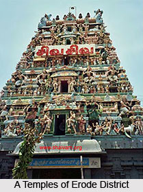
Temples in Erode District
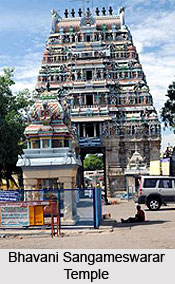 Temples in Erode district are many and are known as Kongunad. The Cholas, Hoysalas and the Pandyas have contributed their mite in the construction of the temples in the district of Erode. There are about four hundred and eighty seven temples in the Erode district. They are located in four taluks, Bhavani, Gobichettipalayam, Erode and Dharapuram. Of the two hundred and seven recognized as padal Petra sthalam, there are two temples found in Erode district called Bhavani and Kodumudi. The Bhavani Sangameswarar temple is situated at the junction of two rivers, the River Bhavani and the River Cauvery. It is called South Prayag and is having a Pagoda of one hundred and twenty inch in height. It is believed that Bhavani and Amudha (not seen now) join Kaveri at this junction, like Jamuna and Saraswati join at Allahabad, Prayag. It is believed to have existed even before the days of the first Kind Mahendravarma of Pallava dynasty. Thirugnanasambandar, one of the four Tamil saints, had sung in praise of this temple. Poet Vasudevan wrote the history of the temple in `Bhavani Kudal Puranam` in Sanskrit.
Another prominent temple in the district of Erode is the Bannari Mariamman temple, which is located at a distance of fifteen kilometres from Bhavani Sagar town on the road to Mysore. It is a place of pilgrimage during the annual festival known as `Kundam` which takes place in the middle of March every year. Huge numbers of pilgrims on that particular day visit this temple from the state of Kerala, Tamil Nadu and Karnataka. Kundam or the fire spot where devotees walk is sixty feet in length and nearly twenty five cart loads of fire wood are piled and kindled. About a lakh of persons including men, women and children take part in this walking.
Sri Aggnigunda Kali or Kodantha Kaliamman temple is another important temple situated forty kilometres from Erode and three kilometers from Gobichettipalayam. This temple is known for fire walking which is held in the month of January every year where more than a lakh of people take part. There is also a Jain Temple at Vijayamangalam. It is twenty five kilometres from Erode. The temple was constructed by the Jain King Konguvelir about one thousand and eight hundred years ago. Chennimalali Sri Subramaniyaswamy temple is one of the notable temples in this district which is located on a hill about one thousand seven hundred and fifty feet height and about thirty five kilometres from Erode. One can find a cave at this place and it is believed that Pinnakku Siddhar, one of the eighteen Siddhars of South stayed and performed yoga in this cave.
Sri Magudeeswarar and Veeranarayana Perumal temple at Kodumudi is located in the bank of Kaveri River and it is about forty kilometers from Erode. Saints Thirugnanasambandar, Thirunavukkarasar and Sundarar visited this place and each one of them composed one Thevaram in honour of this temple. The special feature of this shrine is that the Tirumurtis; Lord Brahma, Lord Vishnu and Lord Shiva, are seen together in one and the same place. The direct rays of the sun penetrate on the images of Swamy and Amman for four days during the months of Avani and Panguni (which are September and April respectively in the English calendar). The Moolavar Sri Magudeeswararswamy is a Swayambu Lingam. This is a very old temple, which is more than one thousand and five hundred years old. The Pandyan Kings made several renovations to this temple. Adiperukku (from July to August), Chithirai and Panguni Uthiram (from April to May) are the major festivals of this temple. At the time of Panguni Uthiram festival, devotees carry `Kavadi` to Palani Temple from here.
 The devotees take bath in the sacred Kaveri River and carry the sacred water in a kalasam to Palani Murugan temple. More than five lakhs of people visit this temple for this festival every year and most of the devotees carry the Kalasam having the sacred Kaveri water, and walk the entire distance of about one hundred and twenty kilometers to Palani.
The Sivanmalai temple is at a distance of forty five kilometers from Erode and the temple is devoted to Lord Subramanian. In Aadi (from July to August) and Thai (from January to February), there are two important festivals celebrated here. Thaipoosam, Panguni Uthiram and Skanda Shasti in the month of Aippasi (November) are the prominent festivals of this temple. It is said that God Sri Subramania, the presiding deity of this temple appears in dreams to a spiritual man or woman and demanded some offerings like bicycle, silver coins, gold chains movable and immovable things. The devotee brought them to the temple and worshipped the God Subramania and till now this is going on.
Sri Kadu Hanumanthaswami temple is also another temple of religious importance which is located at Dharapuram, about eighty kilometers from Erode. The temple is mostly worshipped by people belonging to Madhwa community. Lord Hanuman is the son of Wind God or Vayu Baghavan and in order to represent this, an opening is left above the Sanctum Sanctornm enabling the presiding deity to enjoy wind, sun and rain alike. It is rare to find any notable temple in South India without a Vimanam or Tower above the Sanctum. In the ten day long festival, which falls in the month of Vaikasi or May, there is a Car Festival which is also celebrated.
Apart from these, there are several other well-known temples located in the Erdoe district of Tamil Nadu state. These temples are Natturayaswami Temple, Veerakumarasami Temple and Bhagavan Temple. Even if Lord Muruga is worshipped in the Veeramumaraswami temple, no woman is permitted to enter the temple and worship the God there. The Bhagavan temple at Ponnivadi is known to cure epidemics like plague, smallpox and cholera.
Recently updated articles in States of India

History of Thissur District
Early History of Thissur District explains flourishing of the port cities. Now these port cities are transformed into archaeological sites.

Tippi Orchid Research Centre, Arunachal Pradesh
Tippi Orchid Research Centre in Arunachal Pradesh is renowned for its rich collection of exotic and endangered orchids. Surrounded by lush rainforest...

Tourism in Nashik District
Pilgrimage tourism in Nashik district involves visiting the various places of Hindu and Jain worship located here. Some of the holiest sites for Hind...

Mangadu, Kerala
Mangadu in Kerala’s Kollam district is a significant megalithic site known for its urn burials, cist burials, menhirs, and stone circles. Excavations...

Devaswom
History of Devaswom is not very ancient and can be dated back to late seventeenth century.
Related articles in States of India

East Indian States
East Indian States comprises of Bihar, Jharkhand, West Bengal, Odisha and also the Union Territory of Andaman and Nicobar Islands. It defines the cult...

Purnia District in Bihar
Purnia District is located in Bihar and extends from River Ganga to Nepal. The district has a rich Hindu history and glorious past.

Hooghly district
Hooghly District along the bank of the river Hooghly is one of the principal trading ports of West Bengal.

Geography Of Chittoor District
Geography of Chittoor district is spread along the topography of the land which is divided into two natural divisions; Chittoor has a dry and healthy...

Districts of West Bihar
Districts of West Bihar is comprised of medieval monuments that were built by the different governors of Mughal era.