 Sathyamangalam also spell, as Satyamangalam is lies on Bhavani River. Sathyamangalam is also named as the reserve forest under the wild life protection Act 1973.It is formed as a taluk of Erode district.
Geography of Sathyamangalam
Sthyamangalam is bounded at north by Chamarajnagar District and Kollegal divisions, south by Gobichettipalayam and Sathyamangalam towns, east by Erode division and west by Bandipur and Nilgiri north division.
Latitudinal Limit of Sathyamangalam
Sathyamangalam covers the total area of 1360 sq km. It is located at 11 degree 29 minutes to 11 degree 48 North latitude and 76 degree 50 minutes to 77 degree 27 minutes East longitude. The annual average of rainfall is 850 milimeters.
Population of Sathyamangalam
Sathyamangalam had a population of 33,738. Males constitute 51% and females 49% of the population. 9% of the population is under 6 years of age. Sathyamangalam has an average literacy rate of 67%, higher than the national average of 59.5%: male literacy is 74%, and female literacy is 61%.
Economy of Sathyamangalam
 Agriculture is the most important income source of Sathyamangalam. The paddy, Banana, Groundnut, Cotton and Sugarcane are some of the agricultural products. In Sathyamangalam Taluk Floriculture is an important source of income.
Tourism in Sathyamangalam
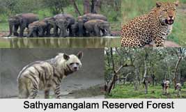
Sathyamangalam is contiguous with the Biligirirangan Temple Wildlife Sanctuary to the north in neighbouring Chamarajanagar District of Karnataka, and together forms a vital corridor for faunal movements, mainly elephants. Sathyamangalam forest is tropical dry forestpart of the South Deccan Plateau dry deciduous forests ecoregion. It includes thorn forest, dry deciduous forest, and tropical hill forest. Many of the higher elevations of the Bilgirirangan range have shola, or dwarf moist deciduous forest, and Montane Grasslands and Shrub-Lands habitats. These forests also harbour indigenous tribal people belonging largely to the Mullu Kurubas, Soliga communities. Southwards, the heights decrease into the arid Coimbatore plains before rising again into the Nilgiris and Anamalais. The forests are home to Asian Elephants, and the herd that ranges between the Western Ghats and Eastern Ghats through the Sathyamangalam forests numbers 6000 animals, the largest herd in India. The forests were also the home of the Indian bandit Koose Muniswamy Veerapan, who made a living exploiting ivory and sandalwood from the forests and selling them on the black market.
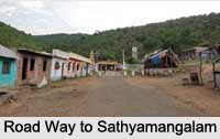
Sathyamangalam
Sathyamangalm is a municipal city of Erode district of the Indian state Tamil Nadu. This city is famous for Sathyamangalam Reserved Forest.


