Home > Travel > States of India > Chamarajanagar District
Chamarajanagar District
Chamarajanagar District is predominantly an agrarian district of Karnataka. Chamarajanagar District was formed in the year 1997 by carving out of Mysore District.

Share this Article:

Chamarajanagar District, Karnataka
Chamarajanagar District is one of the administrative districts of Karnataka with its headquarters located at Chamarajanagar town. Chamarajanagar District was carved out of Mysore District.

Total area covered by Chamarajanagar District is 5686 sq kms. This district was one of the seven new districts formed on 15th of August, 1997. Those seven districts are Chamarajanagar, Udupi District, Davanagere District, Haveri District, Koppal District, Gadag District and Bagalkot District.

Economy of Chamarajanagar District
Economy of Chamarajanagar District is basically agrarian in character. Agriculture is the backbone of the economy. The main occupation of the people of this district is farming and other allied activities. Most of the lands of the region are dry lands. Since, the irrigation facility is very sparse in the district the farmers are largely dependent on seasonal rains to grow their crops. Maize, jowar, paddy, cowpea, groundnut, cotton, sunflower and sugarcane are the major crops that are grown in the district. The district is traditionally known for Sericulture activities with a total area of 8,601.59 hectares under mulberry cultivation. Coconut, banana, turmeric, and various vegetables are also grown. Sericulture is a traditional activity in Chamarajanagar District.

In terms of number of families engaged in rearing silk worms as also the area under mulberry crops, Chamarajanagar District occupies a prominent place. The district is having around 431 Sericulture villages. The integrated rural cottage industries ancillary to sericulture supports large number of families and provides direct and indirect employment. Average size of sericulture farms in the district is nearly 1.5 to 2 acres.

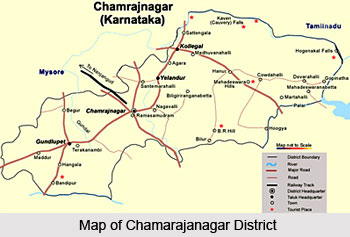
Chamarajanagar District also has several tourist places that are worth exploring and they attract travellers from all parts of the country.

This article is a stub. You can enrich by adding more information to it. Send your Write Up to [email protected]


Share this Article:

Related Articles

More Articles in States of India


East Indian States
East Indian States comprises of Bihar, Jharkhand, West Bengal, Odisha and also the Union Territory of Andaman and Nicobar Islands. It defines the cultural heritage, rich historical background and the linguistic unity.
Erode District
Erode District is one of the districts in the state of Tamil Nadu. The district of Erode is having a land-locked area with no sea coast.
Purnia District in Bihar
Purnia District is located in Bihar and extends from River Ganga to Nepal. The district has a rich Hindu history and glorious past.
South Delhi District
South Delhi District is the third largest district of Delhi as far as its area is concerned. South Delhi District is known for its economic, historical, cultural and social significance.
North Indian States
North Indian States formed the cultural and religious unity in spite of having many foreign invasion and the political disturbances from the early era till the British gained supremacy in Indian sub continent.
Kendujhar District
Kendujhar District, spread over an area of 8,240 sq kms, is as varied as the whole of Orissa with waterfalls roaring gorges, mountains and minerals. The manifold expressions of nature in Kendujhar District are considered as unique.
Hooghly district
Hooghly District along the bank of the river Hooghly is one of the principal trading ports of West Bengal.
Districts of South Tamil Nadu
Districts of South Tamil Nadu consist of many tourism destinations like archaeological sites and the history of Pandyas and Cholas. Considering their proximity to the sea, many districts also boast of serene beaches and coastal beauty.
Flora of Arunachal Pradesh
Flora of Arunachal Pradesh includes infinite species and is a subject of great interests for the botanists.
Districts of South Gujarat
Districts of South Gujarat are the epicenter of Jain pilgrimages and the early Hindu kingdoms.
North West States of India
North West States of India consist of three states, which are Rajasthan, Punjab and Haryana. All of them are culturally and traditionally diverse and they have been ruled by different dynasties in historical time.
Geography Of Chittoor District
Geography of Chittoor district is spread along the topography of the land which is divided into two natural divisions; Chittoor has a dry and healthy climate.
Districts of North Rajasthan
District of Northern part of Rajasthan is dotted with ancient forts and medieval villages.
Districts of North Odisha
District of North Odisha has Bengal boundary and shares the same culture. These are reachable if one pays a weekend visit to Digha.
Districts of West Bihar
Districts of West Bihar is comprised of medieval monuments that were built by the different governors of Mughal era.
Districts of South Haryana
Districts of South Haryana consists of many cities of industrial excellence. These districts are dotted with popular tourism destinations.
Medieval History of Assam
Medieval history of Assam narrates the advent and rule of a number of kingdoms in the region. The prominent dynasties of the kingdom left an everlasting imprint on the socio cultural heritage of India.
Geography of Meghalaya
The suitable climate, highland plateaus, rivers and the flora and fauna together forms the geography of Meghalaya.
Districts of Rayalaseema
Districts of Rayalaseema in Andhra Pradesh state has urban population and rural settlements as well.
Districts of South Punjab
Districts of Southern part of Punjab depict medieval history of Punjab and the rise of Sikhs.