Introduction
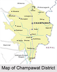 Champawat District is a rural district in the north Indian state of Uttarakhand. Being a newly formed and remote district no important Research Institution is situated in Champawat District. Only a Krishi Vigyan Kendra of Pantnagar Agricultural University exists at Lohaghat. Champawat District of Uttarakhand was constituted in the year 1997. Champawat town is the district administrative headquarters, which is 76 kms from Pithoragarh headquarters, Champawat is situated 1615 meters above sea level. The long chain of mountain in southwestern region acts as a border between Champawat District and Nainital District. It is important from the defense point of view as the east Kali river acts as the international border between Nepal and India.
Location of Champawat District
Champawat District is situated between 29 degree 5 minutes and 29 degree 30 minutes in northern latitude and 79 degree 59 minutes and 80 degree 3 minutes at the center of eastern longitude. Ram Ganga River acts as a border between Champawat and Pithoragarh in north while Jabgura and Pannar rivers in south and west act as a border between Champawat District, Udham Singh Nagar District and Almora District simultaneously.
History of Champawat District
 According to the history of Champawat District, it owes its name to the name of the daughter Champawati of King Arjun Deos. History suggests that earlier Champawati District was a part of Almora District. In 1972, Champawat Tehsil of Almora District was transferred to Pithoragarh. On 15th of September, 1997 Champawat District was given an independent identity. It is said that since time immemorial Champawat District has had its own importance in terms of religious and social aspects.
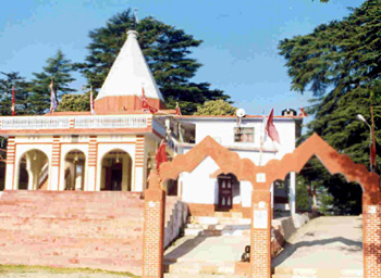
Further, as per the history, it is believed that Champawat District is the source and origin of religion and culture of Uttarakhand. In the ancient time this region was the origin of Naga, Kinnar and Khas Raja`s. The available historical pillars, manuscripts, archeological collection and folk-lore describe the greatness of the area during the period of Mahabharata. Barahi Temple of Devidhura, Tarkeshwar Mandir of Champawat, Vanasur Fort of Vishung, Baleshwar Mandir of Champawat, Sapteshwar Mandir of Sipti and Ghatotkasha temples are believed to be of the great period of Mahabharata. The ample evidence is also available about the Katiyur dynasty and its prosperity in ancient times. There is a belief that king Brahma Deo and King Raja Arjun Deo was having his capital at this region. In around 1790, with the establishment of the Gorkharaj, the Chandra Vansha came to its end. In 1814, the British government forced the Gorkhas to leave the place. In the history of Indian independence the history of the warriors of this region has been written in golden letters for their sacrifices.
The history of Champawat District states that the region, once the capital of the rulers of the Chand dynasty, is famous for its natural beauty and well known temples. A historical spot, Champawat has many well known temples of high artistic value. The Baleshwar temple is the noted attraction of Champawat. The Nagnath temple at Champawat is also an excellent example of ancient architecture of Kumaon. The story of Golla Devta is also associated with Champawat. It was in Champawat that Lord Vishnu is said to have appeared as `Kurma Avatar`. This hill is also known as Mount Kandev and there is also a small ancient fort located at Champawat.
Geography of Champawat District
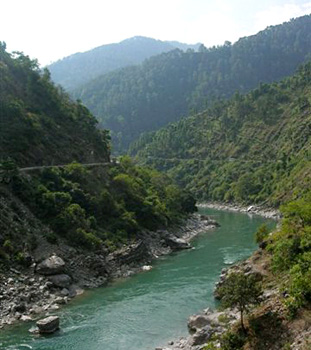 Geography of Champawat District mainly consists of mountain ranges, large valleys, uneven landscapes, cliffs, significant rivers and rivulets. The important rivers flowing through the district are Ladhia, Sharda, Lohawati, Panaar, Jagbura and Ramganga River. All these rivers amalgamate with Kali River at Pancheswar. Only the Sharda River which goes to Terai area flows through. And on the basis of geographical distribution it can be divided in three main parts. First one, 35 villages of Tanakpur (Purnagiri) Tehsil fall in Terai area and are important from the view point of plain and agricultural land and are warm area of an average height of 200 to 250 metres, having abundance of water and good soil. Second one is Shivalik Hills which is situated at a height of 250 to 1200 metres. It represents a sloping and uneven topographical land consisting of dense forests. Third one is hilly area the average height of 1500 metres (from 1200 to 2200 metres).
The climate of Champawat District is very differential. Terai area is hot whereas the hilly region is comparatively cold. High mountain ranges are covered with snow. The climatic condition of Terai and plains are similar, the seasonal rain is very high (about 20 cm yearly). Summers are too hot and winters are too cold and foggy in Terai region. The climate of Shivalik is more or less same but the lower region of Himalaya Mountains experience cold climate throughout the year. In summers, Champawat District has a pleasant weather. The temperature varies from 1 degree Celsius in the year to 35 degree Celsius. Summer months are May, June and July whereas December and January are very cold.
Around 65 percent area of Champawat District is covered with fauna and flora. Rest 35 percent is used as agricultural, non-agricultural and grazing land. Besides the hills, the plains are vegetated with plenty of exotic and traditional variety of plants such as Eucalyptus, Babul, Teak, Sagon, Jamun Tree, Bans, Bail, Madar etc. The 900 to 1800 metres slope of the southern hills is full of Chir trees. Besides this, the region is having various useful plants such as Amla, Ayer Tun and Khatic. The forest of the region is blessed with diverse kinds of wild life and beautiful birds. Many ores, minerals, soils and rocks are available in the hills of Champawat District. According to geological survey of India this region is having ample of lime, magnexide, soapstone, gypsum. Apart from these various ores and minerals are also available in this region such as ognexide, quanite, graphite etc.
Climate of Champawat District
 The climate of Champawat District is basically pleasant. Champawat District also possesses various species of flora and fauna. Champawat District is also rich in mineral resources.
Demography of Champawat District
According to the Population Census in the year 2011, Champawat district has a population of 259,648. Champawat District has a population density of 147 inhabitants per square kilometer.
Economy of Champawat District
In Champawat District 65 percent of the area is under forest and net sown area is less than 10 percent. Only about 9 percent of the sown area is irrigated and agriculture is manly rain fed. Consequently, it is at a subsistence level and only traditional crops are grown. Around 82 percent of workers are engaged in agriculture and there are negligible workers in household or non household industries. Thus, economy of Champawat District is based on agriculture and to some extent on minor forest produce and vegetable production.
Lack of agricultural land and resources has always been a reason for the poor economic status of the rural areas of the district. The agricultural production is less as compared to the effort put in. The economic condition of Champawat and Lohaghat is comparatively better due to seasonal production of fruits.
A few males are involved in conventional traditional work for the maintenance of livelihood, such as pottery, carpentry, blacksmith etc. Few villagers are also involved in animal husbandry. There are no small or medium scale industries in the region. As a result majority of population of the youth are unemployed.
Champawat District is characterized by money order economy as a large number of males are working outside in big cities like Delhi, Lucknow, Mumbai, etc. either in the armed forces or other jobs since there are very less employment opportunities in the district. Champawat District is economically and socially backward with acute poverty and society ridden with outmoded traditions and even superstitions.
Tourism in Champawat District
 Tourism in Champawat District will include visits to several places of religious as well as historical interest. Champawat District is mainly known for its scenic beauty and this aspect enhances the charm of travelling. There are few ancient forts that offer the visitors a glimpse of the rich history associated with the district. Some of the major tourist attractions of Champawat District are as follows.
Pilgrimage Tourism in Champawat District
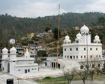
Reetha Sahib: It is located at a distance of 72 kms from Champawat. Guru Nanak is said to have visited this place and have had spiritual discussions with Gorakhpanthi Jogis. The Gurudwara was constructed in 1960 at the confluence of Lodhiya and Ratiya rivers, near village Deyuri. A fair is held at the Gurudwara on Baisakhi Purnima.
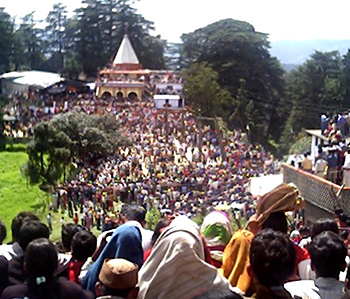
Devidhura: At distance of 45 kms from Lohaghat, Devidhura is famous for its Barahi temples. A very unusual fair, which attracts people from distant places, is held every year at the temple of Barahi Devi on the occasion of Raksha Bandhan. During this festival, known as Bagwal, two groups of dancing and singing people throw stones at each other, while they try to protect themselves with the help of large wooden shields. The famous hunter, Jim Corbett`s tale `Temple Tiger` is associated with the Devidhura temples. Devidhura is situated amidst tall deodar and oak trees surrounded by beautiful native flora and fauna. This is a wonderful place for trekking.
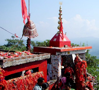
 Purnagiri Temple: Purnagiri is 20 kms from Tanakpur, 171 kms from Pithoragarh and 92 kms from Champawat. Purnagiri temple is visited throughout the year by large number of devotees from all parts of the country, particularly during Chaitra Navratri in the month of March and April. The surrounding valleys echo with the holy chants of the devotees climbing up to the top for darshan, creating an atmosphere of spirituality. From Purnagiri, also known as Punyagiri, Kali River descends into the plains and is known as Sharda.
Mayawati Ashram: 22 km from Champawat and 9 km from Lohaghat, this ashram is situated at an altitude of 1940 metres. Mayawati shot into prominence after the establishment of Advait Ashram here. The ashram attracts followers across the country as well as abroad. Amid an old tea Estate, is the Advait Ashram of Mayawati. During his third visit to Almora in 1898, Swami Vivekananda decided to shift the publication office of `Prabuddh Bharat` to Mayawati. The only presence that has become a part of the peace and solitude of Mayawati is that of the mighty Himalaya in its entire splendor. There is also a library and a small museum at Mayawati.
 Pancheshwar: 40 kms from Lohaghat at the confluence of river Kali and Saryu, Pancheshwar is famous for the temple of Chaumu, its fair and a dip at the confluence is considered to be very sacred. The temple at Pancheshwar is devoted to Lord Shiva.
Leisure Tourism in Champawat District
Vanasur Ka Kila: This is a fort at an elevation of 1859 metres, 7 kms from Lohaghat and 20 kms from Champawat. The names of Shonitpur and Lohawati are linked with the myth about the assassination of Vanasur at this place. The fort seems to be a construction belonging to the middle ages, but the story of Vanasur was probably associated with the spot even before the construction of the fort. Lohawati River originates near this place.
Nature Tourism in Champawat District
Lohaghat: Lohaghat, which is situated on the bank of river Lohawati, is a centre of historical and mythological importance. Further, in summer season, Lohaghat is full of Burans flowers, which are worth seeing.
Shyamlatal: Shyamlatal is 132 kms from Pithoragarh and 56 kms from Champawat. Swami Vivekananda Ashram is located here at the bank of the lake. The blue coloured lake of Shyamlatal is spread over an area of about one and a half sq km. This place has some ruins dating back to the days of the early Chand rulers and others which were associated with the Pandavas. Shyamlatal is also famous for its Jhula fair. Different varieties of roses also attract the travellers here.
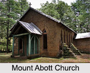
Mount Abbot: Abbot Mount is situated amidst a thick forest of oak and deodar and is one of the main tourist attractions of Champawat District. From Abbot Mount one gets a breathtaking view of the Himalayan peaks.
These are some of the main attractions of Champawat District that are worth exploring. With these tourist interest places and amazing scenic beauty, Champawat District holds a prominent position in the tourist map of the country.


