
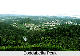
 Dodabetta is the highest mountain in the Nilgiri Hill. It stands at a height of 2623 meters (8652 feet) above mean sea level. The peak offers a bird`s eye view of the whole of Coimbatore. One of the most amazing features about Doddabetta is its flat summit. Other attractions of the mountain are its forests, vegetation and shrubs to name a few. Every year, the mountain draws quite a good number of tourists from various parts of the world.
Etymology of Doddabetta Peak
The term Doddabetta is an amalgamation of two words including Dodda and betta. Dodda means big and betta means mountain.
Location of Doddabetta Peak
Dodabetta is located in the Tamil Nadu state of India. It is four kilometres in the southeast of Udagamandalam which was formerly called Ooty in the Nilgiri district.
Attractions of Doddabetta Peak
Doddabetta Peak is surrounded by beautiful other peaks, forests and greenery. Hecuba at a height of 2375 meters, Kattadadu at a height of 2418 meters and Kulkudi at a height of 2439 meters are three peaks located in the west of Doddabetta range. The beautiful Chamundi Peak can be seen from this peak.
 Doddabetta has a unique flattened curve at its pinnacle. The surrounding area of the peak is enveloped with reserved forest which is home to various endangered species of flora and fauna. Shola vegetation covers the slopes and slightly short rhododendron trees in the middle of the thick coarse grass and the flowering sub-elphine shrubs and herbs are common even near the summit.
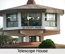
There is a `Telescope house` at the top which provides stunning views of the surrounding hills, waterfalls, forests etc. The house is run by Tamil Nadu Tourism Development Corporation.
Trekking at Doddabetta Peak
The peak also offers interesting activities like trekking and hiking. The trek begins from south-east of Ooty. While trekking, one will encounter coarse grass and flowering shrubs which makes the journey more appealing. According to many, the trek up to the top of the peak is not that difficult and therefore is a good destination for the old as well as the very young enthusiasts. The peak can also be accessed with the help of a road which has access to vehicles.









