Home > Travel > States of India > Chumbi Valley
Chumbi Valley
Chumbi Valley is at the intersection of India, Bhutan and China (Tibet) in the Himalayas.

Share this Article:

Chumbi Valley, SikkimChumbi Valley is a valley on the south side of the Himalayan drainage divide, near the Chinese border with Sikkim, India and with Bhutan. The Chumbi Valley is connected to Sikkim to the southwest via the mountain passes of Nathu La Pass and Jelep La Pass.

Formerly in Sikkim, Chumbi Valley became part of Tibet in 1792. The inhabitants of the valley are called Promowa and are of Tibetan descent. Extensive trade in wool, yak tails and borax passed through the valley after British negotiations resulted in the establishment of a trade agency at Yadong and a treaty between the British and Tibet in 1904. Since 1951 the valley has been under the control of China, which continued trade with India until 1962, when a 1954 treaty between China and India over the status of Tibet expired, and a border dispute between the two countries erupted.

Location of Chumbi Valley
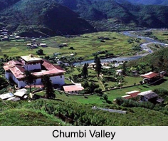
Chumbi Valley is situated on a small south-pointing protuberance of territory between Bhutan (east) and Sikkim state, India (west). Formed by the passage of the Torsa River, which rises below Tang Pass and flows south into Bhutan, the Chumbi valley has an average elevation of 9,500 feet (2,900 metres), forested slopes, and a pleasant climate most of the year.

Military Expeditions on Chumbi Valley
Being on one of the primary routes between India and Tibet, the Chumbi Valley has been at the forefront of several military expeditions. The Delhi Sultanate`s attempted invasion of Tibet in 1206 and reached the Chumbi Valley. The British military expedition of 1904 occupied the Chumbi Valley for about 3 years after the hostilities to secure Tibetan payment of indemnity. Contemporary documents show that the British continued the occupation of Chumbi Valley until February 8, 1908, after having received payment from China.

This article is a stub. You can enrich by adding more information to it. Send your Write Up to [email protected]


Share this Article:

Related Articles

More Articles in States of India


East Indian States
East Indian States comprises of Bihar, Jharkhand, West Bengal, Odisha and also the Union Territory of Andaman and Nicobar Islands. It defines the cultural heritage, rich historical background and the linguistic unity.
Erode District
Erode District is one of the districts in the state of Tamil Nadu. The district of Erode is having a land-locked area with no sea coast.
Purnia District in Bihar
Purnia District is located in Bihar and extends from River Ganga to Nepal. The district has a rich Hindu history and glorious past.
South Delhi District
South Delhi District is the third largest district of Delhi as far as its area is concerned. South Delhi District is known for its economic, historical, cultural and social significance.
North Indian States
North Indian States formed the cultural and religious unity in spite of having many foreign invasion and the political disturbances from the early era till the British gained supremacy in Indian sub continent.
Kendujhar District
Kendujhar District, spread over an area of 8,240 sq kms, is as varied as the whole of Orissa with waterfalls roaring gorges, mountains and minerals. The manifold expressions of nature in Kendujhar District are considered as unique.
Hooghly district
Hooghly District along the bank of the river Hooghly is one of the principal trading ports of West Bengal.
Districts of South Tamil Nadu
Districts of South Tamil Nadu consist of many tourism destinations like archaeological sites and the history of Pandyas and Cholas. Considering their proximity to the sea, many districts also boast of serene beaches and coastal beauty.
Flora of Arunachal Pradesh
Flora of Arunachal Pradesh includes infinite species and is a subject of great interests for the botanists.
Districts of South Gujarat
Districts of South Gujarat are the epicenter of Jain pilgrimages and the early Hindu kingdoms.
North West States of India
North West States of India consist of three states, which are Rajasthan, Punjab and Haryana. All of them are culturally and traditionally diverse and they have been ruled by different dynasties in historical time.
Geography Of Chittoor District
Geography of Chittoor district is spread along the topography of the land which is divided into two natural divisions; Chittoor has a dry and healthy climate.
Districts of North Rajasthan
District of Northern part of Rajasthan is dotted with ancient forts and medieval villages.
Districts of North Odisha
District of North Odisha has Bengal boundary and shares the same culture. These are reachable if one pays a weekend visit to Digha.
Districts of West Bihar
Districts of West Bihar is comprised of medieval monuments that were built by the different governors of Mughal era.
Districts of South Haryana
Districts of South Haryana consists of many cities of industrial excellence. These districts are dotted with popular tourism destinations.
Medieval History of Assam
Medieval history of Assam narrates the advent and rule of a number of kingdoms in the region. The prominent dynasties of the kingdom left an everlasting imprint on the socio cultural heritage of India.
Geography of Meghalaya
The suitable climate, highland plateaus, rivers and the flora and fauna together forms the geography of Meghalaya.
Districts of Rayalaseema
Districts of Rayalaseema in Andhra Pradesh state has urban population and rural settlements as well.
Districts of South Punjab
Districts of Southern part of Punjab depict medieval history of Punjab and the rise of Sikhs.