Introduction
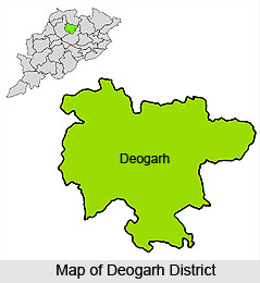 Deogarh District is ideally located at the western region of Orissa and is at the east of the Sambalpur town. Deogarh District was newly created on 1st of January, 1994 being bifurcated from Sambalpur District. It is a backward district domicile by Scheduled Tribe population. As it is a district with no industries the people solely depends upon agriculture. Deogarh District comprises one municipality, one Tehsil and three development blocks consisting of 774 villages. Total area occupied by Deogarh District is 2781.66 sq km.
Location of Deogarh District
Deogarh District is situated in the western region of the state having its headquarters located at Deogarh. Deogarh Town is 90 kms to the east of Sambalpur town. National Highway No.6 passes through the district and the district acts as the main artery of inter-regional trade and other links. Deogarh District is located ideally between 21 degree 31 minutes 53 seconds north latitude and 84 degree 43 minutes 2 seconds east longitude.
History of Deogarh District
The history of Deogarh District is also pretty engaging. Bamara - the bastion of creative artists dates back to the 5th century A.D, when the Maratha Royal family was at the helm of administration. Originally the present district of Deogarh was identified with the region of Bamara. But the history of Deogarh came to be recorded with the advent of the Ganga rulers as the supreme authority following the Marathas. The Gangas established their capital city in Deogarh and right from that time Deogarh came to be known with separate identity in the political scenario of Orissa. As the historical records of Deogarh relate, during the reign of Basudev Sudhal Dev, the most enlightened ruler of the Ganga clan. Deogarh achieved a thriving prosperity. The Gangas, very much sophisticated stimulated an all round growth and prosperity in Deogarh. As far as the history of Deogarh is concerned, during the reign of Raja Basudev Sudhal Dev, a new horizon was innovated in the field of the communication with the establishment of the Jagannath Ballav Press in 1886 and publication of a weekly magazine the `Sambalpur Hitaishini` in 1889. Moreover, the raja, in order to induce a strong foundation of administration wanted to strengthen the law and order of the state.
The history of Deogarh says that, the king efficient enough established the police station, jail and post offices, which ensure law and order of the kingdom along with the increased opportunity of communication. Moreover the Ganga ruler encouraged the technical know-how to elevate the standard of agricultural economy of Deogarh, which was the very base of the state`s economy at that time. With the direct intervention of the king dispensaries were established and the irrigation system was also introduced. The telephone line introduced by him in 1900 was considered as the longest one in India at that time. The postal stamp and the paper currency promulgated by the Ganga kings are itself the important source of the history of Deogarh. Following Raja Basudev Sudhal Dev, his son Raja Sachidananda Tribhuban Dev consecrated the throne with the solemn aim to carry out the welfare and the improvement programmes started by his father.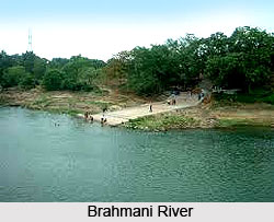 The history of Deogarh during the reign of Raja Sachidananda Tribhuban Dev is marked with outstanding developmental activities with the introduction of the hydroelectric system in Kodarkot waterfall. However on 1st of January, 1948, the estate of Bamara, of which Deogarh is a part, is annexed with the district of Sambalpur.
The history of Deogarh says that, the king efficient enough established the police station, jail and post offices, which ensure law and order of the kingdom along with the increased opportunity of communication. Moreover the Ganga ruler encouraged the technical know-how to elevate the standard of agricultural economy of Deogarh, which was the very base of the state`s economy at that time. With the direct intervention of the king dispensaries were established and the irrigation system was also introduced. The telephone line introduced by him in 1900 was considered as the longest one in India at that time. The postal stamp and the paper currency promulgated by the Ganga kings are itself the important source of the history of Deogarh. Following Raja Basudev Sudhal Dev, his son Raja Sachidananda Tribhuban Dev consecrated the throne with the solemn aim to carry out the welfare and the improvement programmes started by his father.
The history of Deogarh during the reign of Raja Sachidananda Tribhuban Dev is marked with outstanding developmental activities with the introduction of the hydroelectric system in Kodarkot waterfall. However on 1st of January, 1948, the estate of Bamara, of which Deogarh is a part, is annexed with the district of Sambalpur.Geography of Deogarh District
This District is entirely of hilly tract. The hill system of Deogarh has been categorised mainly under four ranges such as the Khajuria Range on the north having a maximum height of 745 metres, the Pradhanpat and Kaidanta range having maximum height of 743 metres and 816 metres on the north, the Pawri Range on the eastern side of the Brahmani River which is around 678 metres in height and lastly Ushakothi range is having elevation that is ranging from 610 metres to 762 metres from the mean Sea levels. Deogarh District mainly has sandy soils and Red Soil.
Demography of Deogarh District
As per 2001 Census, total population of Deogarh District is 2,74,095 out of which male population is 1,38,425 and female population is 1,35,670. The population density per sq km in Deogarh is just around 145 while that of Orissa as a whole is 236. Thus Deogarh can be said to be a district where the population is relatively sparse in comparison to other districts of Orissa. Deogarh shares this feature with most other western and northern Orissa districts. According to 2001 Census, literacy rate of the district is 60.78 percent, of which male literacy rate is 73.79 percent and female literacy rate is 47.56 percent.
The clasping hilly ranges, the effervescence of the red soil laces Deogarh District. The nearest airports for visiting places of interest in Deogarh District are at Bhubaneswar and Raipur.
The clasping hilly ranges, the effervescence of the red soil laces Deogarh District. The nearest airports for visiting places of interest in Deogarh District are at Bhubaneswar and Raipur.
Tourism in Deogarh
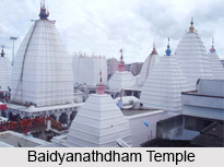 Tourism in Deogarh is largely influenced by religion as the region is a popular Hindu pilgrimage destination. It has the mixture of tribal cult and Hindu religion. Deogarh, the home of Gods, is steeped in history. Several temples and places of ritual were established to celebrate and worship the Gods and deities. Deoghar, which in Hindi literally means abode of the Gods. Deoghar houses the Baidyanath Temple, one of the twelve Shiva Jyothirlingams as well as one of the 51 Shakti Peethas in India. Tourism in Deogarh is well developed and has several popular destinations that attract tourists from all over the country through out the year. Baidyanathdham Temple, Nandan Pahar, Shivganga, Naulakha Mandir, Harila Jori, Satsanga Ashram are the tourist attractions of Deogarh.
Tapovan : Tapovan, located 10 km away from Deoghar, has a Shiva temple which attracts several pilgrims. The temple is known as Taponath Mahadeva. A number of caves are also found in the hill.
Baidyanathdham Temple : Baidyanath or Shiva Temple is the most significant of all the temples in the region. The Baidyanathdham temple faces the east and is a simple rock-cut structure, along with a pyramidal tower, which is 72 feet tall. The summit has 3 ascending shaped gold vessels, which were donated by the Maharaja of Giddhaur, are efficiently set. Apart from these pitcher shaped vessels, there is also a Punchsula, 5-headed Trident, which is unique.
Chandrakanta Mani : Chandrakanta Mani, which is an 8-petal lotus jewel, is placed in the inner top. The Shiva lingam is installed inside, and has a cylindrical forming about 5 inches in diameter. The top of the lingam is damaged and has jagged surface. Bells affixed in the ceiling and pilgrims sound the bell in order to declare their advance to the divinity.
Nandan Pahar : Nandan Pahar is a small hill on the edge of Deogarh which houses a famous Nandi Temple. The temple vicinity is properly maintained by the local authority. Nandan Pahar faces the famous Shiv temple and has a large children`s park. There is also a boot house, a ghost house and a mirror house in here.
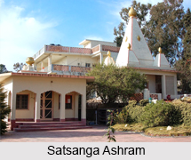
Satsanga Ashram : Satsanga Ashram is a sacred site for the devotees of Shri Shri Thakur Anukulchandra. The Satsang Ashram, located in the south-west region of Deoghar, was established by Sri Sri Anukul Chandra. The Ashram performs various reform and welfare activities for the society and for the improvement of humanity. Visitors from India and overseas come to the Ashram, through out the year.
Basukinath Temple : Basukinath Temple is a renowned Temple of Shiva. Basukinath is located around 43 km from Deoghar, close to the village of Jarmundi and is well connected by road. The Shiva Temple is indigenous and boasts local artworks.
Naulakha Mandir :
 Naulakha Mandir is a beautiful spot, located 1.5 km away from Baba Baidyanath Temple. This temple looks like the temple of Ramakrishna Paramhansa in Belur. Inside it there are idols of Radha - Krishna. Its height is 146 feet. The amount spent in construction of the temple was about Rs. 900,000 (9 lakhs). Hence it became known as Naulakha Temple.
Ramakrishna Mission of Deogarh : This is a boarding school which is operated by the monks of Ramakrishna Mission. The campus is full of vegetation and has several sporting fields. The Ramkrishna Mission Vidyapith was set up in 1922 with the objective of imparting modern education along with the values of ancient culture.
Rikhia Ashram : Rikhia Ashram, which is a Bihar School of Yoga was established by Swami Satyananda Saraswati. A yearly fair, festival and ceremony, is held in November-December and attracts numerous devotees from various corners of the globe. The ashram is a holy place and the charitable deeds hugely benefit the local villages.
Shivganga : Shivganga is basically a pond located almost 200 m from Baidyanath Temple. According to the legends of Ramayana, Ravana created the water body by punching the earth and water came out and formed a pond.
Trikut Pahar : Trikut Pahar, 2,470 feet in height, is situated 13 km away from Deoghar and the presence of three main peaks on the hill attributes to the name Trikutachal. Trikutachal Mahadeva Temple, a temple of Shiva, is present in the Trikuth Parvat. There is also an altar of the goddess of Trishuli. It is an attractive place with a cool stream flowing.
Prabhu Jagadbandhu Ashrama : The ashram has a stone-temple of Prabhu Jagadbandhu. This small ashram is beautifully adorned with flowers and situated within a pristine landscape.
Ram Nivas Ashram : Ram Nivas Ashram is covered by trees and gardens and contains temples of Tripura Sundari, Radha-Krishna, and Bhagbati Devi. Sri Sri Balananda Brahmachari Maharaj used to reside here.


