Sinla Pass is a high Himalayan mountain pass located in the eastern Kumaon in Pithoragarh District of Uttarakhand. This pass connects Bidang in Darma Valley to Jolingkong Lake in the Kuthi Yankti Valley. This pass was the part of ancient trade route of Bhutia Tribe to Tibet.
Location of Sinla Pass
The Sinla Pass is bounded by Tibet in the north and Nepal in the east. It is an high altitude mountain passes in the Indian Himalayan region and located at an elevation of 5,495 meters.
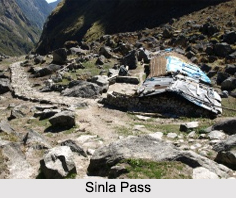
Route to Sinla Pass
The route to Sinla Pass is under a heavy blanket of snow all year round. It is steep on both the sides and rocky. From here one can constantly see the Chota Kailash or the Adi Kailash Peak. The trek route of Sinla Pass goes through lush green fields, remote villages and virgin forests.
This article is a stub. You can enrich by adding more information to it. Send your Write Up to content@indianetzone.com
(Last Updated on : 18-03-2019)
|
|
|
|
|
|
|
Recently Updated Articles in Geography of India
|
|
|
• | History of Indian Forests History of Indian Forests reveals a constant process of exploitation and preservation. The history of Indian forests is rather intimately associated with the political history of the state.
| | • | Forests in Ancient India FForests in Ancient India and forestry traditions have been wonderfully documented in the religious literary texts. Both protective as well as productive aspects of Forests in Ancient India can be found in the various traditional literary texts like Vedas, Puranas and the great Epics.ests in Ancient India and forestry traditions have been wonderfully documented in the religious literary texts. Both protective as well as productive aspects of Forests in Ancient India can be found in the various traditional literary texts like Vedas, Puranas and the great Epics.
| | • | Koyna Dam Koyna Dam is the largest dam in Maharashtra. This dam has been constructed in the Koyna Nagar nestled in the Western Ghats between Chiplun and Karad. It originates from Mahabaleshwar, a hill station in the Sahyadris Mountain Range.
| | • | Jindhagada Peak Jindhagada Peak is the tallest peak of Eastern Ghats Mountain Range.
| | • | Eastern Coastal Plains The Eastern Coastal plains extend amongst the sea coast from Subarnarekha River to Kanyakumari and Eastern Ghats. The Deltas of Mahanadi, Godavari, Kaveri and Krishna River traverse these plains. The eastern coast has several sub categories in it as well.
| | |
|
|
|
|