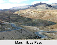
 Situated in the Chang Chenmo Range of the northern Himalayan Mountain Range, the Marsimik La Pass stands at an altitude of 5, 582 m and is known to contain one of the highest motorable passes of the country. There is also a small temple in Marsimik called the "Chak Mandir" which has a picture of Lord Shiva.
The Marimik La Pass is located about 96 km east of Leh and about 20 km northeast of the northwest tip of Pangong Lake. The Pass lies in close proximity of just 4 km west of Indo-China actual line of control and from there about 45 km northeast is the Kongka Pass.
This article is a stub. You can enrich by adding more information to it. Send your Write Up to content@indianetzone.com


