Home > Travel > States of India > Darma Valley
Darma Valley
With a rich flora and fauna, the Darma Valley is famous for trekking and exploring the Kumaon Himalayas.

Share this Article:

Darma Valley, Pithoragarh District, Uttarakhand
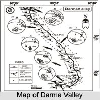
Situated in the eastern part of the state of Uttarakhand in the Pithoragarh District of the Kumaon Division, the Darma Valley is a Himalayan valley. Formed by the Darma River, the valley is situated between 2 valleys: the Kuthi Yangti valley to the east and the Lassar Yangti to the west. The Darma valley links the Lassar Valley by Gangachal Dhura and connects with Kuthi Valley by Sinla Pass and Nama Pass.

The Darma valley stretches southwards from the Dawe village on the Sino- Indian border and at Tidang, it joins the Lassar Valley. Here, it is called Dhauli Ganga until it confluences in the river Kali at Tawaghat. A rivulet called Nyola Yangti that drains Panchachuli east glaciers flows into Dhauli Ganga at Dugtu-Dantu village. The Darma Valley is also known to have a rich flora consisting mostly of orchids.

Demographics of Darma Valley
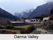
With a population less than 1000 people, the Darma Valley is inhabited by about 12 villages, where the main occupation of the people is livestock rearing and trading. The villagers also cultivate crops, commonly buckwheat and potatoes which are famous in the valley. It is said after the migration of the 1970s, cultivated land has decreased to 25% of former size, allowing biodiversity to return to Darma Valley.

Darma Valley, Pithoragarh District, UttarakhandMajor Peaks of Darma Valley
The Darma Valley has 3 major peaks, out of which the tallest is the Panchchuli massif standing at a height of about 6, 334 m to 6, 904 m. It is followed by the Om Parvat, which is close to the Adi Kailsah Mountain and is at an elevation of 6, 191 m and lastly there is the peak of Yungtangto, which stands at a height of 5, 945 m.

Darma Valley Trek
The undulating picturesque landscape of the Darma Valley is interspersed with verdant forests, captivating waterfalls and streams, along with magnificent alpine meadows which host colourful wild flowers. Trekking here is an exciting experience as with inner line permits, trekkers are allowed to the snow capped peaks of Panchchuli or Meola Glacier.

Visiting Information on Darma Valley
The Darma Valley is well-connected with major regions of Uttarakhand through motorable roads. The nearest railway station is the Kathgodam railway station while the Pantnagar Airport is the closest to the valley.


Share this Article:

Related Articles

More Articles in States of India


East Indian States
East Indian States comprises of Bihar, Jharkhand, West Bengal, Odisha and also the Union Territory of Andaman and Nicobar Islands. It defines the cultural heritage, rich historical background and the linguistic unity.
Erode District
Erode District is one of the districts in the state of Tamil Nadu. The district of Erode is having a land-locked area with no sea coast.
Purnia District in Bihar
Purnia District is located in Bihar and extends from River Ganga to Nepal. The district has a rich Hindu history and glorious past.
South Delhi District
South Delhi District is the third largest district of Delhi as far as its area is concerned. South Delhi District is known for its economic, historical, cultural and social significance.
North Indian States
North Indian States formed the cultural and religious unity in spite of having many foreign invasion and the political disturbances from the early era till the British gained supremacy in Indian sub continent.
Kendujhar District
Kendujhar District, spread over an area of 8,240 sq kms, is as varied as the whole of Orissa with waterfalls roaring gorges, mountains and minerals. The manifold expressions of nature in Kendujhar District are considered as unique.
Hooghly district
Hooghly District along the bank of the river Hooghly is one of the principal trading ports of West Bengal.
Districts of South Tamil Nadu
Districts of South Tamil Nadu consist of many tourism destinations like archaeological sites and the history of Pandyas and Cholas. Considering their proximity to the sea, many districts also boast of serene beaches and coastal beauty.
Flora of Arunachal Pradesh
Flora of Arunachal Pradesh includes infinite species and is a subject of great interests for the botanists.
Districts of South Gujarat
Districts of South Gujarat are the epicenter of Jain pilgrimages and the early Hindu kingdoms.
North West States of India
North West States of India consist of three states, which are Rajasthan, Punjab and Haryana. All of them are culturally and traditionally diverse and they have been ruled by different dynasties in historical time.
Geography Of Chittoor District
Geography of Chittoor district is spread along the topography of the land which is divided into two natural divisions; Chittoor has a dry and healthy climate.
Districts of North Rajasthan
District of Northern part of Rajasthan is dotted with ancient forts and medieval villages.
Districts of North Odisha
District of North Odisha has Bengal boundary and shares the same culture. These are reachable if one pays a weekend visit to Digha.
Districts of West Bihar
Districts of West Bihar is comprised of medieval monuments that were built by the different governors of Mughal era.
Districts of South Haryana
Districts of South Haryana consists of many cities of industrial excellence. These districts are dotted with popular tourism destinations.
Medieval History of Assam
Medieval history of Assam narrates the advent and rule of a number of kingdoms in the region. The prominent dynasties of the kingdom left an everlasting imprint on the socio cultural heritage of India.
Geography of Meghalaya
The suitable climate, highland plateaus, rivers and the flora and fauna together forms the geography of Meghalaya.
Districts of Rayalaseema
Districts of Rayalaseema in Andhra Pradesh state has urban population and rural settlements as well.
Districts of South Punjab
Districts of Southern part of Punjab depict medieval history of Punjab and the rise of Sikhs.