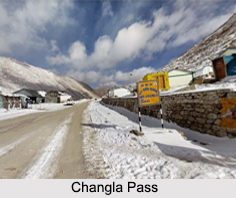
 Changla Pass is a high mountain pass in Ladakh, Jammu and Kashmir. It is claimed to be the second highest motorable road in the world. It is the main gateway for the Changthang Plateau situated in the Himalayas. The pass is 15-km long and the roads are absolutely steep. The pass is guarded and maintained by the Indian Army due its proximity to Chinese border. Changla Pass is mainly used to reach the Pangong Lake, a popular tourist attraction, from Leh.
Etymology of Changla Pass
The name "Changla" literally means "Northern Pass" where "Chang" means north and "La" means "Pass". It is also believed to have been named after a famous Sadhu named "Sadhu Changla Baba". A temple dedicated to him stands here today. The nomadic tribes staying in this region are collectively known as the "Chang-pa".
Route to Changla Pass
Changla Pass is approached from Leh via Kharu and Sakti village by an asphalt road. The climb is very steep and requires a careful drive. The stretch of 10-15 km road on either side from Changla is loose dirt and slush. During the summer months, small streams appear across the road, making the climb a challenge for the bikers. The descent from Changla towards Tangtse or Darbuk is again very steep. The small town of Tangste is the nearest settlement. As per the medics, it is advisable to not stay at the top for more than 20-25 minutes as it could be detrimental to health owing to its high altitude.
The world"s highest research station, established by the Defence Research and Development Organisation is functional in Changla Pass at a height of 17,664 ft. Some of the places to see around Changla pass are the Pangong Lake, Nubra valley, Tso Moriri Lake and Hermis Gompa.
This article is a stub. You can enrich by adding more information to it. Send your Write Up to content@indianetzone.com


