Home > Travel > States of India > Bhilangana Valley
Bhilangana Valley
The Bhilangana Valley is a Reserve Forest area and falls under the bio-geographic zone.

Share this Article:

Bhilangana Valley, Uttarakhand
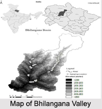
Located in the Tehri district of the state of Uttarakhand, the Bhilangana Valley is along the Bhilangana River and spreads over an area of 1009.24 sq. km. The Bhilangana Valley is surrounded from east and west by the ridges of Vasuki tal and Sahastra tal respectively, and from north and south, the valley is surrounded by the Khatling glacier and Tharti division.

Climate of Bhilangana Valley
Since the Bhilangana Valley is located in the Himalayan region, the climate varies according to the elevation and gets colder as the height increases and wetter as the elevation drops. Hence, there is a change in the temperature and humidity of the region with sudden occurrences of rain, floods, high winds, snowstorms and other types of precipitation. During the summer months, the Bhilangana Valley experiences a tropical type of climate and the zone of maximum precipitation during both summer and winter lies between 1200 m and 2100 m.

Flora of Bhilangana Valley
Being a Reserve Forest area, the Bhilangana Valley is accessible to the locals and the Gujjar communities. The area around the valley had variations of exposure to sunlight and the elevation affected the climatic conditions thus giving rise to diversity in vegetation. Reports have suggested that there are 9 forest types in the western Himalayan region.

Fauna of Bhilangana Valley
Due to lack of wildlife related research in the area, there is no accurate account about faunal diversity in the Bhilangana Valley. But recent findings have revealed that the valley is as diverse in flora as it is in fauna when compared to the rest of the western Himalayas. Broadly the six Mammalian orders which are present here are Primates, Carnivora, Artiodactyla, Rodentia, Lagomorpha and Chiroptera, including endangered and rare species such as Himalayan brown bear and musk deer.

This article is a stub. You can enrich by adding more information to it. Send your Write Up to [email protected]


Share this Article:

Related Articles

More Articles in States of India


East Indian States
East Indian States comprises of Bihar, Jharkhand, West Bengal, Odisha and also the Union Territory of Andaman and Nicobar Islands. It defines the cultural heritage, rich historical background and the linguistic unity.
Erode District
Erode District is one of the districts in the state of Tamil Nadu. The district of Erode is having a land-locked area with no sea coast.
Purnia District in Bihar
Purnia District is located in Bihar and extends from River Ganga to Nepal. The district has a rich Hindu history and glorious past.
South Delhi District
South Delhi District is the third largest district of Delhi as far as its area is concerned. South Delhi District is known for its economic, historical, cultural and social significance.
North Indian States
North Indian States formed the cultural and religious unity in spite of having many foreign invasion and the political disturbances from the early era till the British gained supremacy in Indian sub continent.
Kendujhar District
Kendujhar District, spread over an area of 8,240 sq kms, is as varied as the whole of Orissa with waterfalls roaring gorges, mountains and minerals. The manifold expressions of nature in Kendujhar District are considered as unique.
Hooghly district
Hooghly District along the bank of the river Hooghly is one of the principal trading ports of West Bengal.
Districts of South Tamil Nadu
Districts of South Tamil Nadu consist of many tourism destinations like archaeological sites and the history of Pandyas and Cholas. Considering their proximity to the sea, many districts also boast of serene beaches and coastal beauty.
Flora of Arunachal Pradesh
Flora of Arunachal Pradesh includes infinite species and is a subject of great interests for the botanists.
Districts of South Gujarat
Districts of South Gujarat are the epicenter of Jain pilgrimages and the early Hindu kingdoms.
North West States of India
North West States of India consist of three states, which are Rajasthan, Punjab and Haryana. All of them are culturally and traditionally diverse and they have been ruled by different dynasties in historical time.
Geography Of Chittoor District
Geography of Chittoor district is spread along the topography of the land which is divided into two natural divisions; Chittoor has a dry and healthy climate.
Districts of North Rajasthan
District of Northern part of Rajasthan is dotted with ancient forts and medieval villages.
Districts of North Odisha
District of North Odisha has Bengal boundary and shares the same culture. These are reachable if one pays a weekend visit to Digha.
Districts of West Bihar
Districts of West Bihar is comprised of medieval monuments that were built by the different governors of Mughal era.
Districts of South Haryana
Districts of South Haryana consists of many cities of industrial excellence. These districts are dotted with popular tourism destinations.
Medieval History of Assam
Medieval history of Assam narrates the advent and rule of a number of kingdoms in the region. The prominent dynasties of the kingdom left an everlasting imprint on the socio cultural heritage of India.
Geography of Meghalaya
The suitable climate, highland plateaus, rivers and the flora and fauna together forms the geography of Meghalaya.
Districts of Rayalaseema
Districts of Rayalaseema in Andhra Pradesh state has urban population and rural settlements as well.
Districts of South Punjab
Districts of Southern part of Punjab depict medieval history of Punjab and the rise of Sikhs.