Home > Travel > States of India > Barak Valley
Barak Valley
With three administrative districts, the Barak Valley is part of the eastern state of Assam.

Share this Article:

Barak Valley, Assam
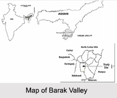
Located in the southern region of the eastern state of Assam, the Barak Valley is named after the Barak River, which is one of the inland waterways of India. The Valley mainly consist of 3 distinct administrative districts namely Cachar, Karimganj and Hailakandi and the main city of the Barak Valley is Silchar. The Barak Valley has two Lok Sabha seats; it is from the Karimganj and Silchar constituencies.

History of Barak Valley
Originally part of the Tripura kingdom, the Barak Valley has been annexed and its administrative head had changed over the centuries. First, in 1562, the Cachar region was annexed by Nara Narayan"s younger brother Bir Chilarai. The region was annexed to the Koch kingdom and was administered by Kamal Narayan, their half brother and after the demise of Nara Narayan, the Cachar region passed on to the Kachari kingdom. Later in the 18th century, the Kachari king also annexed the region of Hailakandi to the Kachari kingdom.

Later in the year 1832, during the time of the British colonialism, the kingdom of Kachari was annexed to British- India. The British Companies established a total number of 157 tea estates in the area and Silchar, headquarter of the district emerged as a very important centre in this part of the country.

More than a century later, during the time of the Indian Independence, a plebiscite was held in Sylhet, which later famously came to be known as the 1947 Sylhet referendum. Here, the district was divided in two and the eastern part of Sylhet which is known as Karimganj remained with India whereas the other part fell under East Pakistan.

Demography of Barak Valley
As per the reports of Census India 2011, the majority religion in the Barak Valley is Hinduism with about 50 percent of the total population. In the Cachar district, Hindus are in majority with a percentage of about 59.83 percent. The other religious compositions of the Valley consists of Muslims about 48 percent, Christians about 1.6 percent and the rest 0.2 percent. The districts of Hailakandi and Karimganj have the maximum number of Muslims with 60.31 percent and 56.26 percent respectively.

Wildlife Sanctuaries of Barak Valley
The Borail Wildlife Sanctuary is the only wildlife sanctuary of the Barak Valley region, which was initiated by noted naturalist Dr Anwaruddin Choudhury, who originally hailed from this region in the early 1980s. This sanctuary was ultimately notified in 2004. Other than this, Hailakandi have the Inner line reserve forest and Katakhal reserve forest. Barak Valley used to be the home of the Asian elephants but currently they are mostly endangered and cannot be found on the valley.

Visiting Information on Barak Valley
The Barak Valley is well connected via roadways, airways and railways and can be easily accessed. The Silchar railway station is the closest at a distance of 29 km and the Silchar Airport is the nearest at about 54 km away from the valley.


Share this Article:

Related Articles

More Articles in States of India


East Indian States
East Indian States comprises of Bihar, Jharkhand, West Bengal, Odisha and also the Union Territory of Andaman and Nicobar Islands. It defines the cultural heritage, rich historical background and the linguistic unity.
Erode District
Erode District is one of the districts in the state of Tamil Nadu. The district of Erode is having a land-locked area with no sea coast.
Purnia District in Bihar
Purnia District is located in Bihar and extends from River Ganga to Nepal. The district has a rich Hindu history and glorious past.
South Delhi District
South Delhi District is the third largest district of Delhi as far as its area is concerned. South Delhi District is known for its economic, historical, cultural and social significance.
North Indian States
North Indian States formed the cultural and religious unity in spite of having many foreign invasion and the political disturbances from the early era till the British gained supremacy in Indian sub continent.
Kendujhar District
Kendujhar District, spread over an area of 8,240 sq kms, is as varied as the whole of Orissa with waterfalls roaring gorges, mountains and minerals. The manifold expressions of nature in Kendujhar District are considered as unique.
Hooghly district
Hooghly District along the bank of the river Hooghly is one of the principal trading ports of West Bengal.
Districts of South Tamil Nadu
Districts of South Tamil Nadu consist of many tourism destinations like archaeological sites and the history of Pandyas and Cholas. Considering their proximity to the sea, many districts also boast of serene beaches and coastal beauty.
Flora of Arunachal Pradesh
Flora of Arunachal Pradesh includes infinite species and is a subject of great interests for the botanists.
Districts of South Gujarat
Districts of South Gujarat are the epicenter of Jain pilgrimages and the early Hindu kingdoms.
North West States of India
North West States of India consist of three states, which are Rajasthan, Punjab and Haryana. All of them are culturally and traditionally diverse and they have been ruled by different dynasties in historical time.
Geography Of Chittoor District
Geography of Chittoor district is spread along the topography of the land which is divided into two natural divisions; Chittoor has a dry and healthy climate.
Districts of North Rajasthan
District of Northern part of Rajasthan is dotted with ancient forts and medieval villages.
Districts of North Odisha
District of North Odisha has Bengal boundary and shares the same culture. These are reachable if one pays a weekend visit to Digha.
Districts of West Bihar
Districts of West Bihar is comprised of medieval monuments that were built by the different governors of Mughal era.
Districts of South Haryana
Districts of South Haryana consists of many cities of industrial excellence. These districts are dotted with popular tourism destinations.
Medieval History of Assam
Medieval history of Assam narrates the advent and rule of a number of kingdoms in the region. The prominent dynasties of the kingdom left an everlasting imprint on the socio cultural heritage of India.
Geography of Meghalaya
The suitable climate, highland plateaus, rivers and the flora and fauna together forms the geography of Meghalaya.
Districts of Rayalaseema
Districts of Rayalaseema in Andhra Pradesh state has urban population and rural settlements as well.
Districts of South Punjab
Districts of Southern part of Punjab depict medieval history of Punjab and the rise of Sikhs.