 The state of Uttar Pradesh is located in the northern part of India. It is the most populous state in the Republic of India as well as the most populous country subdivision in the world. This state has varied topography, vibrant culture, monuments, museums, temples, etc. They have not only beautified this state but have also helped Uttar Pradesh rank first in domestic tourist arrivals. Lakes of Uttar Pradesh are no exception in this regard. They too have the potential to catch the attention of tourists visiting this state.
Keetham Lake
Keetham Lake is situated outside Agra on the Agra - Delhi highway (NH 2). The lake site experiences hot windy summers and extremely cold winters. U.P. Forest Department is credited with the establishment of woodlands near the lake and development of shallow areas close to it, thereby making the lake area a natural habitat for birds nesting sites. This lake provides resting habitats to more than 106 species of migratory and resident birds.
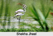
Shekha Jheel
Shekha Jheel is situated near the village of Shekha, 17 km east of Aligarh and 5 km from the Grand Trunk Road (GT Road). This fresh water perennial lake is spread over an area of about 25 ha and was created after the formation of the Upper Ganges Canal in 1852. Shekha Jheel is an ideal site for bird lovers. Many village cattle and villagers pose a threat to the birds at the lake site.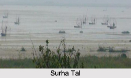
Surha Tal
Surha Tal is located in the district of Ballia. This oval-shaped natural oxbow lake is spread over an area of about 34.32 square kilometers. This lake has maximum length of about 4.5 km. Surha Tal was formed by the meandering of River Ganges. The outlet of the lake"s water is Kathar Nala through which it enters the Ganges.
Moti Jheel
Moti Jheel is located in the Benajhabar area of Kanpur. It acts as an artificial lake and a drinking water reservoir. Moti Jheel has maximum length of about 600 m, maximum width of about 105 m and maximum depth of about 32 ft. This rectangle shaped lake along with the adjoining gardens and children`s park serves as a tourist spot in Kanpur.
Chittaura Jheel
Chittaura Jheel is located about 8 km from Bahraich city, on Gonda Road near Jittora or Chittaura village. Several migratory birds will be visible to the tourists here, during the late monsoon period.
Other Lakes in Uttar Pradesh
Belasagar Lake, Barua Sagar Tal, Darwan Lake, Ramgarh Tal, Darwan Lake and Raja Ka Tal are some of the other Lakes in Uttar Pradesh.


