 The state of Manipur is located in the north-eastern part of India. Its geographical terrain is characterized by misty hills, valleys, cascading rapids, tripling rivers and forests, which have beautified this Jewel of India. These, along with varieties of flowers, exotic blooms, art forms, dances, indigenous games, martial arts, handloom clothes and exquisite handicrafts have the potential to draw tourists to this state. Lakes of Manipur are no exception in this regard. They also have the potential to catch the attention of tourists visiting this state.
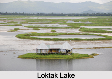
Loktak Lake
Loktak Lake is located close to Moirang. It has the distinction of being the largest freshwater lake in north-eastern India. Manipur River and many small rivulets form the source of this lake whereas its outlet is formed by Ungamel Channel. The catchment area of this lake is about 980 square kilometers (380 sq mi). This lake has maximum length of about 35 km (22 mi), maximum breadth of about 13 km (8 mi) and average depth of about 2.7 m (8.9 ft). It has surface area of about 287 square kilometers (111 sq mi). Some of the faunal species housed in the precincts of this lake in Keibul Lamjo National Park are barking deer, wild bear, hoolock gibbon etc. Fish is the aqua faunal species housed in this lake. Waterfowl, dabbling ducks and diving ducks are some of the avifaunal species of Loktak Lake. Loktak Lake is a part of the Loktak Hydropower Project on the Manipur River or Imphal River. Loss of vegetative cover in the catchment area of the lake and construction of Ithai barrage at its outlet has threatened this lake. Consequently, steps have been initiated to restore this lake.
Ikop Pat
Ikop Pat is a lake located at an elevation of about 772 m above mean sea level in the western part of Khangabok. Characteristically, this lake is a fresh water lake having saucer shaped basin with gentle slope and a much silted bottom. This lake is fed by Arong River and its outlet is via a barrage. The volume of this lake has been recorded as 0.013 cu km. This lake has a length of about 7.5 km and breadth of about 1.8 km during rainy season. It has surface area of about 13.5 square kilometers (5.2 sq mi), maximum depth of about 1.59 m (5.2 ft) and surface elevation of about 772 m (2,533 ft). The quality of this lake has been deteriorated by pollutants. In some parts, the water has been found to be highly acidic (pH-3.6) while in other parts high alkalinity (pH-9.3) troubles this lake.


