 The state of Bihar is located in the eastern part of India. It is the third-largest state in India by population and has an area of about 94,163 square kilometers. The ancient universities of India like Nalanda Vikramashila and Odantapura were located in this state, which primarily supported "educational tourism" here. Bihar is rich in ancient monuments, archaeological sites, forts, pilgrimages, museums, eco center and fairs and festivals which draw a plethora of tourists here. To reach Bihar, domestic as well as international airports have been established in the state.
Jay Prakash Narayan International Airport
Jay Prakash Narayan International Airport is located about 5 kilometers southwest of Patna. This public airport is operated by Airports Authority of India. This airport is spread over an area of about 254 acres and has been provided with one asphalt surfaced runway designated 07/25 and measuring 1,954 by 45 meters. For 2015-2016, an increment of about 32 percent was found in the annual passenger traffic of this airport. There was a proposal made by the Airports Authority of India to extend the airports terminal over an area of about 11.5 acres for maintaining air operations at least till 2035.
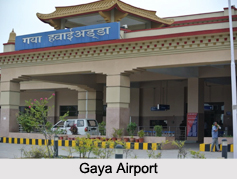
Gaya Airport
Gaya Airport is located in Gaya. This public airport is operated by Airports Authority of India and occupies 954 acres of land. The terminal building of this airport can accommodate about 250 incoming and 250 outgoing passengers. It is the second busiest airport in Bihar and mainly serves the Buddhist tourists coming from Sri Lanka and South East Asian countries.
Raxaul Airport
Raxaul Airport is located in Raxaul. This public airport is operated by Airports Authority of India. Raxaul Airport was established post Sino-Indian War of 1962. It was utilized as a landing ground for the Indian Army during emergency situations.
Munger Airport
Munger Airport is located in Munger. This airport is operated by Airports Authority of India. It is a small airport restricted to VIP movements.
Purnea Airport
Purnea Airport is situated near Purnia. This is a military airport operated by the Indian Air Force.
Bihta Air Force Station
Bihta Air Force Station is located in Bihta. This is also a military airport operated by the Indian Air Force and has been allotted about 900 acres of land.


