Home > Travel > States of India > Mana Pass
Mana Pass
The Mana Pass is a mountain pass located on the border between India and Tibet.

Share this Article:

Mana Pass, Uttarakhand
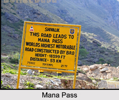
Situated at an elevation of 5,632 m, the Mana Pass is known to be one of the highest vehicle accessible mountain passes in the world. The Mana Pass is located in the Himalayas on the border between India and Tibet. The road connecting the countries of India and Tibet was constructed in a period from 2005 to 2010 by the Border Roads Organisation for the Indian military. This well graded gravel dirt road is higher on the Indian side than the new road on the Tibetan side.

Geography of Mana Pass
The Mana Pass is located within the Nanda Devi Biosphere Reserve, which lies 24 km north of the town of Mana, and 27 km north of the Hindu pilgrimage town of Badrinath in the Indian state of Uttarakhand. Mana is a small village in Chamoli District of Uttarakhand. The village of pristine beauty is located at an altitude of 3,200 meters and is on the northern terminus of National Highway 58.

The Nanda Devi Biosphere Reserve is the source of the Saraswati River, one of the tributary of Ganga River and the Alaknanda River. Saraswati River trickles through the several small ponds between the Mana Pass and Lake Deo Tal, which is 3 km from the southwest of the mountain pass. The Mana Pass also acts as a key road for climbing Chaukhamba peak.

History of Mana Pass
Once an ancient trade route between Uttarakhand and Tibet, the Mana Pass led from Badrinath to the present province of Guge in Tibet. In 1624, two Portuguese Jesuits named Antonio de Andrade and Manuel Marques became the first known Europeans to enter across Mana Pass. Until its closure in 1951 by the Chinese, the Mana Pass was used as a minor trade route. The ban on the mountain pass was lifted on 29th April, 1954, when China and India signed an agreement granting pilgrims and indigenous travellers the right to travel between the two countries through Mana Pass.

Visiting Information on Mana Pass
The Mana Pass can be reached from the south by an extension of National Highway 58 that connects Delhi with Badrinath.


Share this Article:

Related Articles

More Articles in States of India


East Indian States
East Indian States comprises of Bihar, Jharkhand, West Bengal, Odisha and also the Union Territory of Andaman and Nicobar Islands. It defines the cultural heritage, rich historical background and the linguistic unity.
Erode District
Erode District is one of the districts in the state of Tamil Nadu. The district of Erode is having a land-locked area with no sea coast.
Purnia District in Bihar
Purnia District is located in Bihar and extends from River Ganga to Nepal. The district has a rich Hindu history and glorious past.
South Delhi District
South Delhi District is the third largest district of Delhi as far as its area is concerned. South Delhi District is known for its economic, historical, cultural and social significance.
North Indian States
North Indian States formed the cultural and religious unity in spite of having many foreign invasion and the political disturbances from the early era till the British gained supremacy in Indian sub continent.
Kendujhar District
Kendujhar District, spread over an area of 8,240 sq kms, is as varied as the whole of Orissa with waterfalls roaring gorges, mountains and minerals. The manifold expressions of nature in Kendujhar District are considered as unique.
Hooghly district
Hooghly District along the bank of the river Hooghly is one of the principal trading ports of West Bengal.
Districts of South Tamil Nadu
Districts of South Tamil Nadu consist of many tourism destinations like archaeological sites and the history of Pandyas and Cholas. Considering their proximity to the sea, many districts also boast of serene beaches and coastal beauty.
Flora of Arunachal Pradesh
Flora of Arunachal Pradesh includes infinite species and is a subject of great interests for the botanists.
Districts of South Gujarat
Districts of South Gujarat are the epicenter of Jain pilgrimages and the early Hindu kingdoms.
North West States of India
North West States of India consist of three states, which are Rajasthan, Punjab and Haryana. All of them are culturally and traditionally diverse and they have been ruled by different dynasties in historical time.
Geography Of Chittoor District
Geography of Chittoor district is spread along the topography of the land which is divided into two natural divisions; Chittoor has a dry and healthy climate.
Districts of North Rajasthan
District of Northern part of Rajasthan is dotted with ancient forts and medieval villages.
Districts of North Odisha
District of North Odisha has Bengal boundary and shares the same culture. These are reachable if one pays a weekend visit to Digha.
Districts of West Bihar
Districts of West Bihar is comprised of medieval monuments that were built by the different governors of Mughal era.
Districts of South Haryana
Districts of South Haryana consists of many cities of industrial excellence. These districts are dotted with popular tourism destinations.
Medieval History of Assam
Medieval history of Assam narrates the advent and rule of a number of kingdoms in the region. The prominent dynasties of the kingdom left an everlasting imprint on the socio cultural heritage of India.
Geography of Meghalaya
The suitable climate, highland plateaus, rivers and the flora and fauna together forms the geography of Meghalaya.
Districts of Rayalaseema
Districts of Rayalaseema in Andhra Pradesh state has urban population and rural settlements as well.
Districts of South Punjab
Districts of Southern part of Punjab depict medieval history of Punjab and the rise of Sikhs.