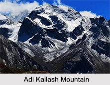
 Adi Kailash is a mountain located at Uttarakhand in India. It is a holy ancient place which is a part of the well known Himalayan range. It is curled up with snow all the time. The place is a spiritual journey to its visitors and a retreat from the every hustle bustle of life. It offers peaceful vibrations and tranquillity to everyone who comes in touch of this divine place. It is very familiar to the Mount Kailash located in Tibet.
Geography of Adi Kailash
The geographic dimensions say it is located in the Indian Territory at Pithoragarh district of Uttarakhand inside proximity of the Indo-Tibetan border. It is located at an altitude of nearly 6,310 metres. It is near the Brahma Parvat and Sin La pass. The former is the base camp of Adi Kailash which is again 17 km from a village called Kutti located at the sacred Jolingkong Lake with one Shiva Temple. The pilgrimage or “Yatra†circuit of Adi Kailash begins by moving straight up towards the Darma Valley and then to Kuthi Yankti Valley through the Sin La pass which joins the Mount Kailash Manasarovar Lake. There is a Tibetan pilgrimage routed downwards the Sharda River.
 Mythological Significance of Adi Kailash
It is said as per the legends, that only eight mountains in India have impression of the OM symbol. The Adi Kailash happens to be the one with the OM symbol out of all these eight mountains. It is a popular pilgrimage of the Hindu devotees. It is associated with variant mythological stories and significance. It is a pious place which is pristinely undisturbed by any form of human activity.
It is known as the oldest place of resting for Lord Shiva. One essential part of the Kailash Trilogy had nestled there in the Himalayas. They are Adi Kailash, Manasrovar and Kinnaur Kailash. A lake exists at the bottom of this mighty peak known as Gauri kund. Near its shoreline, a shirne of Goddess Parvati and Lord Shiva stands. According to the Hindu mythologies, all these places are the abode of Lord Shiva, Goddess Parvati, Lord Ganesha and Kartik Swami. At a little detour from the Adi Kailash, there is a sight of the prepossessing Om Parvat carved on the border of Indo Nepal where a silhouette of "OM" can be found facing India and back of Nepal.
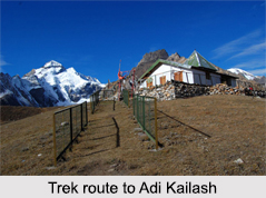
Trek Routes of Adi Kailash
The Himalayas have been widely known as a tourist attraction for its treks. The Adi Kailash is not an exception. The route for trekking to Adi Kailash in Himalayan ranges of Kumaun region near the border of Indo Tibet till Gunji is same. There is a walk of 14km first towards the left of Kuti then towards right will take one to Jollingkong. There is a bridge at river Kuti that is perhaps under a thick snow blanket always. The camps present in this trek are Pangu, Sirkha, Gala and Budhi. The longitude is 80 025" East and the latitude is 300 20"North.


