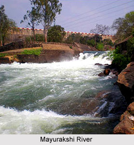
 Mayurakshi River is a major river of the Indian state of West Bengal. It is also known by the name of Mor River. It is known as Matihara at its origin. The meaning of the term `Mayurakshi` is peacock`s eye (mayor or mor meaning peacock and akshi meaning eye). More specifically, the comparison is made with the beautiful feathers on a peacock`s tail. Being famous for its strong currents, it is not subject to amazement that Mayurakshi is related to a natural disaster called floods. This river becomes troublesome during the monsoons. Mayurakshi translates this season into a season of disastrous floods and the valley of the river is most affected by it. On a contrary to the season of floods, this river is named after its clear water of the dry seasons. Massanjore Dam and Tilpara barrage are the major tourist attractions of this river.
Geography of Mayurakshi River
Globally, Mayurakshi River can be pinpointed at coordinates 24 degrees 6 minutes 14 seconds North and 87 degrees 18 minutes 36 seconds East. It has a length of about 250 km (155 mi). It"s catchment area is about 8,530 square kilometers. Annual rainfall over the basin of the river varies between 765 and 1,607 millimetres (30 and 63 in) with an average of about 1,200 millimetres (47 in) of which 80 percent occurs during the monsoon season from June to September. Dumka, Suri, Birbhum and Dubrajpur are the nearby cities of the Mayurakshi River.
Course of Mayurakshi River
Although Mayurakshi River is called a major river of West Bengal, it is important to note that its source and mouth lies in different states of India. This river originates in Jharkhand flows through West Bengal and then meets Hooghly River. Stating more specifically, the Mayurakshi River originates on the slopes of Trikut hill, about 16 km from Deoghar in Jharkhand and about 43 km upstream from Dumka in Bihar state. It then journeys through the districts of Birbhum and Murshidabad in West Bengal and then finally joins the Hooghly River.
Tributaries of Mayurakshi River
As the Mayurakshi River journeys towards south east, it is joined by a number of rivulets, streams and tributaries. Major tributaries of Mayurakshi are Dhobhai, Dwaraka, Bhurburi, Pusaro, Tepra, Sidheswari, Dauna, Kopai, Brahmani and Bakreshwar.
Floods Caused by Mayurakshi River
Mayurakshi River being rain fed is prone to seasonal floods. Since ages the valley of this river is targeted and conquered by floods. As indicated by Tarasankar Bandyopadhyay, seven or eight months in the year the river is a desert - sands stretching from shore to shore for about 1.5 miles (2.4 km). But when the rains come, the river is terrible, demoniac, racing along 4 to 5 miles (6 to 8 km) wide, its deep grey water swamping everything within reach. West Bengal had witnessed major floods in 1978 and consecutive floods in 1998, 1999 and 2000. The 1978 flood was caused by 72 hours of continuous and concentrated rainfall over the western river basin areas of the Bhagirathi, from Pagla-Bansloi to the Ajay. The resultant increase in the water level of the river caused huge flood which washed away all the embankments on the eastern side of the Bhagirathi. Its effect was also seen on the whole of Nadia district, a larger part of Murshidabad district and northern areas of North 24 Parganas district. They remained underwater for a considerable period of time. Birbhum district of West Bengal had witnessed floods in 1787. According to L.S.S. O`Malley, this flood in some places had swept off villages, inhabitants, cattle and crops on the ground along with everything that was moveable. In the Bengal District Gazetteers, L.S.S. O`Malley also mentioned about the flood of 1806 during which Mayurakshi and Ajay had a sudden extraordinary rise and floods destroyed villages. It is also important to note about the flood of September, 1902. It was the time when overflowing Brahmani and the Mayurakshi had partly deluged the nearby country to a dangerous level of 4 to 6 metres (12 to 20 ft). The Harpa flood is also important to note. It is a kind of flood which does not occur frequently. More specifically, it is a once in a while phenomena. It is characterized by six to seven cubits deep water, which has the potential to destroy anything obstructing its way. The Harpa flood is known to engulf nearby villages, ripping off homes and granaries from the land. The Harpa was recorded last about 20 years ago.
It is important to note that floods in these areas occurred so frequently that only five years between 1960 and 2000 were recorded as flood-free years. But even during this period of time, less than 500 square kilometres (190 sq mi) of area was still deluged. To obtain some relief from the adverse effects of floods construction of embankments acted as the only structural measure. Therefore, rivers like Mayurakshi, Brahmani, Dwarka and Ajay are provided with major embankments.
Development of Mayurakshi River
Under the Mayurakshi River Project, a dam called the Massanjore Dam was commissioned to be built across the Mayurakshi in 1955. This Project is considered to be one of the important Multipurpose River Projects in India, helping the Ganga, Orissa and the Punjab. Constructed at a cost of about Rs. 16.10 crore, this dam is also known by the name of Canada Dam. It is because Canada devoted a certain amount for the further development of the Mayurakshi dam project. This amount was extracted from the counterpart rupee fund created through supplies of wheat and other materials from Canada for use in India. Also, the Foreign Minister of Canada, Lester B. Pearson, formally inaugurated this dam. This dam is located about 38 kilometres (24 mi) upstream from Siuri in West Bengal. As per estimations, the Massanjore dam has a length of about 660 metres (2,170 ft) and occupies an area of about 67.4 square kilometres (16,650 acres) when full. It has a height of about 47 metres (155 ft) from the base and has a storage capacity of about 620,000,000 cubic metres (500,000 acreft).
Unfortunately, the Massanjore dam located near Dumka in the state of Jharkhand (erstwhile Bihar) was not allowed to have any flood reserve. Simultaneously with construction of dams the state government in 1956, selectively took over flood control embankments till then maintained by the landlords or local bodies.
Mayurakshi River also developed when it was provided with a Tilpara barrage. This barrage is located about 32 kilometres (20 mi) downstream at Tilpara near Siuri and was built at a cost of about Rs. 1.11 crore. As estimated, this barrage has a length of about 309 metres (1,013 ft).
Mayurakshi River"s Support to Livelihood
With the construction of Massanjore dam on Mayurakshi River, irrigation and electric power generation became a possibility. As estimated, a land of about 2,400 square kilometres (600,000 acres) was thus irrigated. Irrigation had positive impacts on food production in terms of increased yield of approximately 400,000 tons of food annually. As far as power generation is concerned, Massanjore dam is responsible for generating about 2,000 kilowatt of electric power.
Related Articles:
Indian Rivers
Ganga River
Teesta River
Rupnarayan River
Damodar River
Mahananda River
Subarnarekha River
Jaldhaka River
Jalangi River
Kopai River


