Introduction
 Pithoragarh District is one of the administrative districts of Uttarakhand. Pithoragarh town is the district headquarters. This district has internal borders in its northern and eastern sides. This district is beautified with snow capped peaks of Himalaya Mountains. Being the last district adjoining Tibet, Pithoragarh district has tremendous strategic importance.
History of Pithoragarh District
 History of Pithoragarh district reminds of the once flourishing Chand Dynasty. Many temples and ruined forts of Pithoragarh District are the reminiscent of the glorious reign of the Chand rulers. Pithoragarh district is situated in the state of Uttarakhand. This district is beautified with Himalaya Mountains, snow capped peaks, passes, valleys, alpine meadows, forests, waterfalls, perennial rivers, glaciers and springs.
It was in the wake of the Chinese aggression that on 24th of February, 1960, a sizeable section of Almora district was carved into Pithoragarh district with its headquarters at Pithoragarh town. On 15th of September, 1997, Champawat Tehsil, came under Pithoragarh and was carved into Champawat district. The origins of the name Pithoragarh are foggy and there are a number of stories on the same. While some say the name to the King Pithora Chand from the Chand Dynasty, stories on the city getting its name from Prithvi Raj Chauhan by the Chauhan Rajputs are also the part of folklore.
Pithoragarh was under the reign of three generation of Pals and the kingdom extended from Pithoragarh to Askot.
The Brahm Dynasty in Pithoragarh : As per a tamrapatra that dates back to 1420 A.D the Pal dynasty, based out of Askot, was uprooted by Chand Kings. Vijay Brahm of Brahm dynasty from Doti took over the empire as a king. It is believed that Bhartichand, an ancestor of Gyan Chand, had replaced Brahm.
The Chand Dynasty : In 16th century the Chand dynasty again took power over Pithoragarh town and in 1790 built a new fort on the hill where the present Girls Inter College is situated. This fort was ruined by Government of India in year 1962 after china attacked India. The Chand rule at its glory is seen as one of the most prominent empires in Kumaoun.
British Rule in Pithoragarh : British came to this region after 1815. Under the British Raj Pithoragarh remained a Tehsil under Almora District until 1960. After that it was elevated to a district. Under the British empire Christianity developed in this region. The British recruited a large number of local people to its army as well.
The subsequent Government was also not very active to take care of this part of India. Hence Pithoragarh is very much neglected even though there is base for army.
Pithoragarh district was initially a part of Almora district of Uttarakhand. Pithoragarh was created as a separate district in 1960. In 1997 a new district of Champawat was carved out by reorganizing its boundaries.
Geography of Pithoragarh District
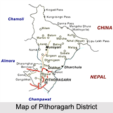
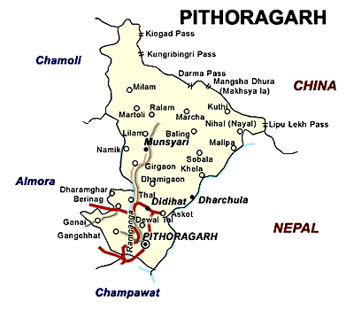
Pithoragarh is located at a height of 1645 metres above sea level. Pithoragarh District lies between 29 degree 4 minutes to 30 degree 3 minutes` north latitude and 80 degree to 81 degree east longitude. Pithoragarh District is located along the eastern and southern part of the central Himalayas with Indo-Tibetan watershed divide in the north and Kali River forming a continuous border with Nepal in the east. Pithoragarh District is surrounded by boundaries of Almora District, Champawat District, Bageshwar District and Chamoli District and extends over an area of around 7,217 sq kms.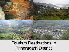
Pithoragarh District abounds in rivers some of which after assuming a peripheral course along the borderline enter the Garhwal region and eventually merges into Ganga River and have thus been geographically grouped under the rivers of the Ganga system. Girthi, Keogad, Kali River, River Garbyang, Dhauli River and Sarju River are some of the main rivers flowing through the district. The northern hilly zone is covered with dense forests, particularly on northern slopes, with an elevation of about 14,000 feet.
Pithoragarh District abounds in rivers some of which after assuming a peripheral course along the borderline enter the Garhwal region and eventually merges into Ganga River and have thus been geographically grouped under the rivers of the Ganga system. Girthi, Keogad, Kali River, River Garbyang, Dhauli River and Sarju River are some of the main rivers flowing through the district. The northern hilly zone is covered with dense forests, particularly on northern slopes, with an elevation of about 14,000 feet.
Demography of Pithoragarh District
According to the 2011 census, total population of Pithoragarh District is 4, 62, 289 out of which male population is 2, 27,615 and female population is 2,34,674. Total literacy rate of the district at present is 75.95 percent. The native tribes of this district are Van Rawats and Bhitiya. These are nomadic tribes.
Administration of Pithoragarh District
Pithoragarh District has been divided into six tehsils namely Munsyari, Dharchula, Didihat, Gangolihat, Berinag and Pithoragarh. It has two sub-tehsils Dewalthal, Kanalichhina having its headquarters at Pithoragarh and the Commissioner headquarters is at Nainital. Administration of Pithoragarh District consists of eight Development Blocks, three towns, 64 Nyay Panchayats and 644 Gram Panchayats. There are 1672 villages in the district out of which 1579 are inhabited.
Tourism of Pithoragarh District
 Tourism of Pithoragarh comprises many snow capped peaks, passes, valleys, alpine meadows, forests, waterfalls, perennial rivers and temples. This district has mesmerizing beauty with hydrographic features. This district is a popular tourist place and is beautified with divine deities, cascading waterfalls, the splendid glaciers, natural reservoirs enclosed by fantastic variety of vegetation, serene lakes and noisy flamboyant rivers.
Some popular tourist places of Pithoragarh district are...
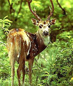
Askot Musk Deer Sanctuary : This Sanctuary is a 599.93 kmý wild life sanctuary situated around Askot near Didihat, in Pithoagarh district of the Himalaya of Kumaon in Uttarakhand, India.
Dharchula : Dharchula is a nagar panchayat in Pithoragarh. Dharchula valley is beautifully surrounded by mountains. This valley is an ancient trading town for the trans-Himalayan trade routes. This place is situated in the banks of Kali River. Dharchula is about 90 km far away from Pithoragarh and it lies on the route to the Kailash-Mansarovar pilgrimage tour. The town is virtually split between India and Nepal near the border with Tibet.
Didihat : A clear view of Himalaya can be viewed from Didihat, 54 kms away from Pithoragarh. The Panchchuli range is clearly seen from this place. Famous Shira-kot Temple of Lord Malay Nath, built by Reka Kings is situated in this place.
Mahakali Temple : This temple is located at Gangolihat and is dedicated to Goddess Kali. It is considered as a Shakti temple. The temple has an aura of mystical charm and during the nights the spirits are believed to have a free sway outside the temple premises.
Patal Bhubaneshwar : This place is famous for an ancient Temple of Goddess Kali-Mother Deity of Indian Army`s Kumaon Regiment. At a distance of 14 km from Gangolihat, there is a village located in Tehsil Didihat, named Bhubaneshwar; where beautiful underground cave of Patal Bhubaneshwar, the subterranean shrine of Lord Shiva is situated with sprawling interiors exist.
Jauljibi : It is an important trading centre bordering Nepal and 68 km from Pithoragarh. Situated at the confluence of rivers Gori and Kali, it is lively fairground. In the fair Bhotia tribes sell their woolen articles. A hanging bridge of rope across Kali joints this place to Nepal.
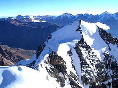
Munsiyari : Munsiyari is located in the northern part of the Pithoragarh district. This small town is situated at the foot of the main Himalayan peaks. This place is a well known base for the track routes to Milam Glacier, Ralam Glacier, and Namik Glacier; at the base of majestic Himalayan peak Trishuli (7,074 m). Alpine lakes of Maheshwari Kund and Thamri Kund encircled Munsiyari. The valley from Munsiyari to Milam is known as Johar Valley.
 Madkot : Madkot is 22 km awayfrom Munsiyari. This place is popular for hot water springs which are supposed to cure rheumatism, arthritis and skin ailments.
Narayan Ashram : A beautiful Ashram established by Narayan Swamy at Sausa near Pangu in 1936, on a way to Lipu Lekh, has a natural beauty. The Ashram was primarily made to help Kailash-Mansarovar pilgrims.
Kailash Mansarover Yatra : The famous Hindu pilgrimage tour to Kailash-Mansarover passes through the district. From Mangti pilgrims have to move on foot.
Pithoragarh Fort : This fort is set atop a hill on the outskirts of the town. The fort was founded by the Gurkhas in 1789. The fort is currently used as a girl`s school.
Kapileshwar Mahadev : The cave temple dedicated to Lord Shiva has fine view of the Soar valley and lofty Himalayan peaks. This temple is three kilometers from Pithoragarh.
Thal Kedar : This old Shiva Temple is known for its scenic splendour. During the annual fair of Mahashivratri large number of devotees and pilgrims gather here.
Jhulaghat : This small town on the banks of river Kali at Indo-Nepal border is named after a hanging rope bridge across the Kali River. Initially it was called `Juaghat`.
Berinag : It is a small town located 102 km from Pithoragarh. This place has sprawling tea gardens at an altitude of 2010 mt. The area has a number of Nag (snake) shrines of Dhaurinag, Feninag, Kalinag, Bashukinag, Pinglenag, and Harinag. Other tourist spots are Tripura Devi Temple, Cave Temple of Koteshwar, Garaun waterfalls, and Musk Deer Farm at Kotmanya. The Berinag is named after the Nagveni King Benimadhava.
Chaukori : This is perhaps the perfect tourist destination to get full panoramic view of snow covered Himalayan peaks in Pithoragarh. It is situated 10 km from Berinag and has an altitude of 2010 m. This place is also known for tea gardens and orchards.
Thal : Thal is situated on the bank of the Ramganga River and is grounded by Kalinag, Sundarinag and Dhaulinag. Thal Valley has its own historical attractions of an ancient temple of Lord Shiva and Ek Hathia Devalaya (temple carved by one stone and by one person in a single night). Hajeti is the perfect place to capture the beauty of Thal valley on foothills of mighty Himalayas.


