Home > Travel > States of India > Didihat
Didihat
Didihat a small town in Pithoragarh district of Uttaranchal, is the pilgrim route to Kailash Mansarovar.

Share this Article:

DidihatDidihat, located in Pithoragarh district of Uttaranchal is a town and nagar panchayat. This town is a tourist destination situated 54km. from Pithorgarh. The word Didihat is taken from a Kumauni word `Dand` which means a small hillock.

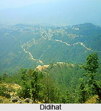
This quaint town situated on the hilltop plain of Digtarh with the Charamgad or Bhadigad river flowing below is indeed a tourists delight. It is a tehsil and subdivision of the Pithoragarh district. It is divided into three developmental blocks- Didihat, Kanalichhina, and Berinag.

Once in the medieval age, Didihat was ruled by feudal Raika Malla kings of Sirakot. Till the time of King Hari Malla, Didihat was under Doti Kingdom of Nepal. Later, in the year 1449 AD at the time of Chand dynasty ruler Bharti Chand, this region came under the control of Chand rulers, when his son Ratna Chand defeated Raikas of Doti. Didihat also possess some remnants of ancient fort and temples. Askot Musk Deer Sanctuary is administratively situated in Didihat Tehsil.

Rich in flora it is situated at an elevation of 1,725 m above sea level, it is a very picturesque and beautiful valley surrounded by green and attractive ridges. It is presently the pilgrim route to Kailash Mansarovar. Didihat offers marvelous views of Panchchuli and Trishuli peaks. The ancient Shirakot Temple of Lord Malay Nath, built by Reika Kings is situated here. Narayan Swamy Ashram at Narayan Nager is another attraction in the vicinity.

According to the 2001 census report, Didihat has a small population of 4805 inhabitants. Males constitute 55% of the population and females 45%. In Didihat, 12% of the population is less than six years of age. Didihat has an average literacy rate of 79%, which is higher than the national average literacy rate of 59.5%. The male literacy rate is 84% and, the female literacy rate is 75%.

This article is a stub. You can enrich by adding more information to it. Send your Write Up to [email protected].


Share this Article:

Related Articles

More Articles in States of India


East Indian States
East Indian States comprises of Bihar, Jharkhand, West Bengal, Odisha and also the Union Territory of Andaman and Nicobar Islands. It defines the cultural heritage, rich historical background and the linguistic unity.
Erode District
Erode District is one of the districts in the state of Tamil Nadu. The district of Erode is having a land-locked area with no sea coast.
Purnia District in Bihar
Purnia District is located in Bihar and extends from River Ganga to Nepal. The district has a rich Hindu history and glorious past.
South Delhi District
South Delhi District is the third largest district of Delhi as far as its area is concerned. South Delhi District is known for its economic, historical, cultural and social significance.
North Indian States
North Indian States formed the cultural and religious unity in spite of having many foreign invasion and the political disturbances from the early era till the British gained supremacy in Indian sub continent.
Kendujhar District
Kendujhar District, spread over an area of 8,240 sq kms, is as varied as the whole of Orissa with waterfalls roaring gorges, mountains and minerals. The manifold expressions of nature in Kendujhar District are considered as unique.
Hooghly district
Hooghly District along the bank of the river Hooghly is one of the principal trading ports of West Bengal.
Districts of South Tamil Nadu
Districts of South Tamil Nadu consist of many tourism destinations like archaeological sites and the history of Pandyas and Cholas. Considering their proximity to the sea, many districts also boast of serene beaches and coastal beauty.
Flora of Arunachal Pradesh
Flora of Arunachal Pradesh includes infinite species and is a subject of great interests for the botanists.
Districts of South Gujarat
Districts of South Gujarat are the epicenter of Jain pilgrimages and the early Hindu kingdoms.
North West States of India
North West States of India consist of three states, which are Rajasthan, Punjab and Haryana. All of them are culturally and traditionally diverse and they have been ruled by different dynasties in historical time.
Geography Of Chittoor District
Geography of Chittoor district is spread along the topography of the land which is divided into two natural divisions; Chittoor has a dry and healthy climate.
Districts of North Rajasthan
District of Northern part of Rajasthan is dotted with ancient forts and medieval villages.
Districts of North Odisha
District of North Odisha has Bengal boundary and shares the same culture. These are reachable if one pays a weekend visit to Digha.
Districts of West Bihar
Districts of West Bihar is comprised of medieval monuments that were built by the different governors of Mughal era.
Districts of South Haryana
Districts of South Haryana consists of many cities of industrial excellence. These districts are dotted with popular tourism destinations.
Medieval History of Assam
Medieval history of Assam narrates the advent and rule of a number of kingdoms in the region. The prominent dynasties of the kingdom left an everlasting imprint on the socio cultural heritage of India.
Geography of Meghalaya
The suitable climate, highland plateaus, rivers and the flora and fauna together forms the geography of Meghalaya.
Districts of Rayalaseema
Districts of Rayalaseema in Andhra Pradesh state has urban population and rural settlements as well.
Districts of South Punjab
Districts of Southern part of Punjab depict medieval history of Punjab and the rise of Sikhs.