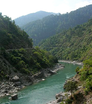
 Geography of Champawat District mainly consists of mountain ranges, large valleys, uneven landscapes, cliffs, significant rivers and rivulets. The important rivers flowing through the district are Ladhia, Sharda, Lohawati, Panaar, Jagbura and Ramganga River. All these rivers amalgamate with Kali River at Pancheswar. Only the Sharda River which goes to Terai area flows through. And on the basis of geographical distribution it can be divided in three main parts. First one, 35 villages of Tanakpur (Purnagiri) Tehsil fall in Terai area and are important from the view point of plain and agricultural land and are warm area of an average height of 200 to 250 metres, having abundance of water and good soil. Second one is Shivalik Hills which is situated at a height of 250 to 1200 metres. It represents a sloping and uneven topographical land consisting of dense forests. Third one is hilly area the average height of 1500 metres (from 1200 to 2200 metres).
The climate of Champawat District is very differential. Terai area is hot whereas the hilly region is comparatively cold. High mountain ranges are covered with snow. The climatic condition of Terai and plains are similar, the seasonal rain is very high (about 20 cm yearly). Summers are too hot and winters are too cold and foggy in Terai region. The climate of Shivalik is more or less same but the lower region of Himalaya Mountains experience cold climate throughout the year. In summers, Champawat District has a pleasant weather. The temperature varies from 1 degree Celsius in the year to 35 degree Celsius. Summer months are May, June and July whereas December and January are very cold.
Around 65 percent area of Champawat District is covered with fauna and flora. Rest 35 percent is used as agricultural, non-agricultural and grazing land. Besides the hills, the plains are vegetated with plenty of exotic and traditional variety of plants such as Eucalyptus, Babul, Teak, Sagon, Jamun Tree, Bans, Bail, Madar etc. The 900 to 1800 metres slope of the southern hills is full of Chir trees. Besides this, the region is having various useful plants such as Amla, Ayer Tun and Khatic. The forest of the region is blessed with diverse kinds of wild life and beautiful birds. Many ores, minerals, soils and rocks are available in the hills of Champawat District. According to geological survey of India this region is having ample of lime, magnexide, soapstone, gypsum. Apart from these various ores and minerals are also available in this region such as ognexide, quanite, graphite etc.


