 Sangli district lies located in the state of Maharshtra along its western part. The district is mainly agricultural in nature, and a total of 1,20,302 hectares are under cultivation. Among the major crops grown in the district are bajra, jowar, wheat, rice, gram, sugarcane, groundnut, turmeric, soybean, pomegranate and grapes. At last count, Sangli district had 3 Sub-Divisions namely Miraj, Walwa (Islampur) and Khanapur (Vita), 10 Talukas and 731 villages. Further details about the district of Sangli are given below.
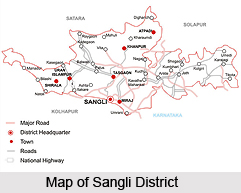
Location of Sangli District
Sangli district is located in the western part of Maharashtra. It is bounded by Satara district and Solapur district to the north, Vijapur district to the east, Kolhapur and Belgaum district to the south and Ratnagiri district to the west. Sangli district is situated in the river basins of the Warna river and the Krishna river. It lies between the North latitudes of 16.4 to 17.1 and the east longitudes of 73.43 and 75.00.
History of Samgli District
There are no direct references to Sangli before 1801. Historical references since 1024 show areas called Mirinch i.e presently Miraj and Karhatak i.e. Karad under the areas ruled by Gonk, a king of the Sillahara dynasty of Konkan, and Sangli was included in these areas. The first clear and direct reference to Sangli can be found in the Sanskrit poem `Shiv-Bharat`. During the time of Chatrapati Shivaji Maharaj, his Sarnoubat Netaji Palkar captured Sangli, Miraj and Brahmnal from Adil shah in 1659. In the times of the Peshwas, Indroji Kadam and later Sardar Patwardhan became the `Jagirdar` of this region. There are several interesting stories as to how the name Sangli originated. One of them is that, there were six Gallies i.e. lanes on the bank of the Krishna River hence the name "Sangli".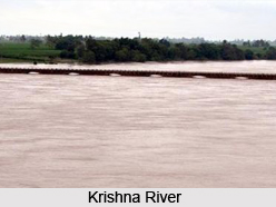 The second one is that, the name of the village was Sangalki in the Kannada language> so in the Marathi language it became Sangli. Till 1801, Sangli was included in the Miraj Jahagir. The First Chintamanrao Appasaheb Patwardhan established a different principality with Sangli as the capital city.
Geography of Sangli District
The physical settings of Sangli district shows a contrast of immense dimensions and reveals a variety of landscapes influenced by relief, climate and vegetation. The climate ranges from the rainiest in the Chandoli (Shirala) region, which has an average annual rainfall of over 4000 mm to the driest in Atpadi and Jath tehsils where the average annual rainfall is about 500 mm. Maximum temperatures in the district reach 42 degree Celsiu, whereas the minimum temperature is usually around 14 degree Celsius. The vegetal cover too varies from the typical monsoon forest in the western parts to scrub and poor grass in the eastern parts. The main rivers of Sangli district are Warna and Krishna. The Krishna is one of the three largest sacred rivers of southern India. Approximately 105 kms of the river course falls inside the district. Morna, Yerla, Manganga, Agrani, Nanni and Bor River are small feeder rivers of Krishna. Warna is the largest tributary of the Krishna in the district.


