Introduction
 On 1st January, 1997 the Tiruvallur District was the newly developed district formed by the bifurcation of the erstwhile Chengalpattu district. Located in the north eastern part of the state of Tamil Nadu, the Tiruvallur District was originally known as Tiruvallur which specifies the sleeping position of holy Lord Balaji. Afterwards, people began to refer Tiruvallur by names like Trivellore and Tiruvallur. The Tiruvallur District is well known today for the Veeraragava Temple.
History of Tiruvallur District
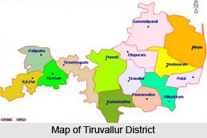
 History of Tiruvallur district in Tamil Nadu deals with the rule of the Pallavas, the Golkondas, the Mughals, the French, the Dutch and also the British. This district in the state of Tamil Nadu in the southern parts of India has been carved out by the bifurcation of the erstwhile Chengalpattu district and according to the said bifurcation Tiruvallur revenue division which included Tiruvallur, Tiruttani taluks and Uthukkottai and Pallipattu sub-taluks separated from Chengalpattu district along with Ponneri and Gummindipoondi taluks of Saidapet revenue division and formed this new district. Presently the district of Tiruvallur consists of eight taluks namely Ambattur, Ponneri, Gummindipoondi, Uthukkottai, Tiruvallur, Tiruttani, Poonamallee and Pallipattu, Madhavaram.
In the earlier days, the region of the Tiruvallur district was under a chain of regimes starting from the Pallavas during the seventh century ending with the Nawabs of Arcot during the earlier parts of the nineteenth century when it came under the British rule. In the year 1687, the Golconda rulers were defeated and the region came under the Mughal Emperors of Delhi. The towns and villages of this region became the scene of the Carnatic war. Battles were believed to be fought in this region during the struggle for supremacy between the English and French. The Pulicat town was the earliest Dutch possession in India founded in the year 1609 which was ceded to the British East Indian Company in the year 1825. With this, the region came under the British rule which ended on the 15th of August, 1947 when India became independent.
Tiruvallur specifies the sleeping position of the holy lord `Balaji` in the Veeraragava temple of Tiruvallur. Later, people of this region started to refer it by names such as Trivellore and Tiruvallur. Today, this district of the Tamil Nadu state is well known, and one of the reasons behind it is the presence of the Veeraragava temple in the district. The new moon day is considered to be greatly auspicious for the lord and also for the people of this region. Thus, the history of the district of Tiruvallur narrates the glorious past of the region which was ruled by a number of famous dynasties.
Geography of Tiruvallur District
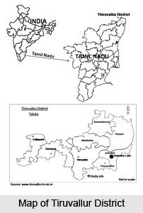
 Geography of Tiruvallur district in Tamil Nadu is suitable for the raising of Casuarina tree. The district of Tiruvallur is surrounded by the Kanchipuram district to the south, the district of Vellore in the west, the state of Andhra Pradesh to the north and the Bay of Bengal to the east. It is spread over a vast area of about three thousand four hundred and twenty two square kilometers. In it locate between twelve degree fifteen minutes and thirteen degree fifteen minutes to the north latitude and between seventy nine degree fifteen minutes and eighty degree twenty minutes to the east longitude. The district of Tiruvallur in the state of Tamil Nadu in India is a newly formed district by the bifurcation of the erstwhile Chengalpattu district on the 1st of January 1997. This is situated in the north-eastern region of the Tamil Nadu state.
The coastal region of this district is mainly flat while some areas in Pallipattu and Tiruttani taluks are undulated and even hilly. The types of soil predominantly found in this district are red non-calcareous and coastal alluvial. Sandy soil mixed with soda or other alkali is also found here. The soil found in the coastal region is of the erinaceous type which is suitable for Casuarina tree. Out of the total geographical area of the district, the not sown area constitute thirty five percent whereas forest covers 5.8 percent. The average rainfall of the district is 1104.4 millimeter, of which the north-east monsoon contributes to the tune of six hundred and ninety millimeter. The average maximum temperature experienced in this district is 37.9 degree Celsius and the average minimum temperature experienced here is 18.5 degree Celsius.
Similar to other parts of the state of Tamil Nadu, hot climate prevails in this district during the month of April-May and humid climate during the rest of the year except December-February when it is slightly cold. The primary occupation of this district is agriculture and allied activities and about forty seven percent of the total work forces are engaged in the agricultural sector. The major crops grown here include rice, black gram, sugarcane, groundnut, etc. Apart from seasonal rivers like Aravar, Kesathaliar, Nandi, Coovam, Kallar and Buckhingham Canal there is no perennial river in the district. Since these seasonal rivers are not sufficient, irrigation through tube wells, tanks and open wells are very common.
There are not much hills of sizeable height present in the district of Tiruvallur. There are quite a few conical hills or ridges of small elevation in this district and some of the hillocks are there in Tiruttani. Most of the hillocks and hills are rocky and no verdant vegetation is seen in their slopes. The area covered by forest in this district is also very small.
Administration of Tiruvallur District
 The Tiruvallur district has been carved out by the bifurcation of the erstwhile Chengalpattu district. As per the said bifurcation Tiruvallur revenue division which included Tiruvallur, Tiruttani taluks, Uthukkottai and Pallipattu sub-taluks separated from Chengalpattu district along with Ponneri and Gummindipoondi taluks of Saidapet revenue division formed this new district. Presently the Tiruvallur District is comprised of 8 taluks namely Ambattur, Gummindipoondi, Ponneri, Uthukkottai, Tiruvallur, Poonamallee, Tiruttani and Pallipattu, Madhavaram. The district of Tiruvallur possesses 3 revenue divisions which are Tiruvallur, Tiruttani and Ponnari. There are 3 taluks under Tiruvallur division, 2 taluks under Tiruttani divisions and 4 taluks under Ponneri division. There are 46 firkas and 820 revenue villages. Likewise there are 14 blocks, 6 municipalities and 19 town panchayats which implement rural development activities.
Demography of Tiruvallur District
As per the reports of Census India 2011, the total population of the Tiruvallur District was 3,728,104 with a sex-ratio of 987 females for every 1,000 males, much above the national average of 929. Children between the ages 0 to 6 years old were 405,669, thus constituting 208,449 males and 197,220 females respectively. When compared to the national average of 72.99 percent, the literacy rate of the Tiruvallur District was higher with 74.88 percent. The district had total of 946,949 households with the Scheduled Castes and Scheduled Tribes accounted for 22 percent and 1.27 percent of the total population respectively.
Education in Tiruvallur District
 Education in Tiruvallur district in Tamil Nadu is well-developed due to its closeness to the metro city of Chennai. There are several educational institutions in the district of Tiruvallur including a number of professional institutions particularly the veterinary university which adds honour to the district`s education sector in the district. The literacy rate in the Tiruvallur district of the Tamil Nadu state is about sixty eight percent of the total population as per 2001 census.
There are one thousand five hundred and forty two schools, one thousand one hundred and thirty eight elementary schools, two hundred and one middle schools, one hundred and twenty four high schools and seventy nine higher secondary schools functioning in this district. All the Higher Secondary Schools are equipped with Computer to impart computer literacy to the students and to the public. There are also institutions for higher education in the district of Tiruvallur in the Tamil Nadu state. There are twelve arts and science colleges, one university and a teacher`s training institute. There are several colleges for professional education including three medical colleges, twenty three engineering colleges and twelve colleges for polytechnic.
The literacy rate of schedule caste and schedule tribes in the district of Tiruvallur in the south Indian state of Tamil Nadu is 52.7 percent. The `Sarva Shiksha Abhiyan` which is also known as `Education for all` is a movement rather than a scheme in order to universalize elementary education by community-ownership of the school system. The aim of this movement is to improve human capabilities of children through provision of community-owned quality education in a mission mode. There are about 153913 boys and about 153913 girls enrolled in the primary and upper primary schools of this district. The total numbers of students enrolled in the schools of this district are about 299366.
Economy of Tiruvallur District
 Economy of Tiruvallur district in Tamil Nadu is largely dependent on agriculture and allied activities. About forty seven percent of the total work forces of this district are engaged in the agricultural sector. Some of the major crops grown in the district are rice, cumbu - ragi, green gram, sugarcane, black gram and groundnut. Apart from this, certain horticultural crops like mango, vegetables and guava have also bean cultivated successfully. Apart from seasonal rivers like Kallar, Kesathaliar, Nandi, Aravar, Coovam and Buckhingham Canal there are no perennial rivers in this district. As these seasonal rivers are not sufficient, irrigation through tanks, open wells and tube wells are commonly found in the district of Tiruvallur.
Animal husbandry is one of the subsidiary occupations of this district due to the presence of a number of small and marginal farmers. It also contributes to some extent to the economy of this district. Presently, there are four Government Schemes in operation including Backyard poultry farm, Special Animal Husbandry Programme, Buffalo Rearing Scheme and special campaign to protect animals. There are five Veterinary Hospitals, twenty four Veterinary Dispensaries, seventy seven sub-centers and fourteen mobile veterinary units catering to the needs of the farming community in this district of the Tamil Nadu state.
The Tiruvallur district in the Indian state of Tamil Nadu is having a coastal area of 49803 hectares and has a coast line of eighty kilometers for marine fisheries. Prawn and shrimp culture is famous at the coast line of Minjur and Gummidipoondi. The total fish production in this district is to the tune of 11372 tonnes. The district of Tiruvallur does not possess any precious mineral resources. However it has a few varieties of major and minor minerals. Some of the major minerals found here are river sand, gravel, blue metal, brick clay, etc and the minor minerals found in this district are lime shell, stoneware clay, silica sand, etc.
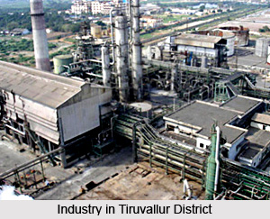
Tiruvallur District is one of the fastest developing in the Tamil Nadu state in terms of industrial development. There are several leading industries like Madras Refineries, Madras Fertilizers, Manali Petro Chemicals, MRF, Ashok Leyland, TI Cycles, Britannia India Ltd, Parry India Ltd and Hindustan Motors. It also boasts of the Ennore Thermal Power Station and the Avadi Tank Factory. The District has sixteen Industrial Estates, all in operation and eleven of them are developed by the Government and five by private organization. This district has sixteen thousand nine hundred and forty Small Scale Industries, notable among them being food, textile, wood, engineering, chemical, non-metallic and leather industries.
Temples of Tiruvallur District
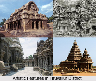
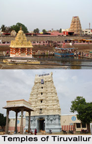 Temples in Tiruvallur district are the major centers of pilgrimage where devotees from different parts of the district and various other parts of India visit throughout the year. Some of the well-known temples of the district of Tiruvallur in the Tamil Nadu state are Lord Siva Temple and Ashramam, Devi Karumariamman Temple, Murugan Temple, Sri Bhavaniamman Temple, Vadivudaiamman Temple, etc. There is an ancient temple for Lord Varadaraja Perumal with his Consort, Pushpakavalli Thayar at Poovirundavalli. Moved by the prayers of Thirukatchi Nambi Alwar; Sri Varadarajaswami, Sri Venkatesaperumal and Sri Ranganathar gave Darshan to him simultaneously at this place. Shrines are there for Thirukatchi Nambi Alwar at this place in the district of Tiruvallur. There is also a Mariamman temple at Poovirundavalli.
A village called Chembarambakka is located about twenty one kilometers away from Chennai. There is an ancient Shiva temple in a dilapidated condition with the walls of the temple adorned with inscriptions of the Chola dynasty. A large and beautiful Shiva lingam is there in the sanctum which is, of course, in a ruined state. Another notable temple in the Tiruvallur district is the Lord Arulmigu Subramaniya Swami temple at Tiruttani located on a hillock with three hundred and sixty five steps. The famous festivals observed here are Shasti Thiruvizha, Shiva Rathiri, Adi Kirthigai Theppa Thiruvizha, etc. Lord Veeraraghava Perumal temple at Tiruvallur district is also a prominent place of pilgrimage and a sacred tank is situated very close to this temple which is known as Hrittapanasini. Apart from these temples, there is another beautiful temple known as Sri Viswaroopa Panchamukha Anjaneyaswami temple which is dedicated to Sri Panchamukha Hanuman.
Ambattur is a township and an industrial center which is located at a distance of sixteen kilometers to the west of the Chennai on the Chennai-Avadi Trunk Road. The temples at this place include the temples for Sri Vinnaraya Perumal and another for Lord Shiva. The temple for Lord Shiva is dilapidated and very old. Temples for Lord Muruga and for the local deity Kannatamman are there in Ambattur. The Mounaswami Matam, which possesses a temple for Sri Bhuvaneswari Amman, attracts a large number of devotees of Mounaswami.
Tourism in Tiruvallur District
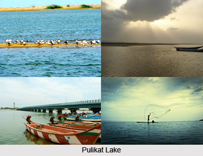
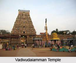 Tourism in Tiruvallur district in Tamil Nadu offers an opportunity to visit a large number of beautiful temples, and a number of natural beauties, etc. Some of the most famous temples of the district of Tiruvallur in the state of Tamil Nadu include Devi Karumariamman temple, Lord Siva temple and Ashramam, Murugan temple, Lord Siva temple, Vadivudaiamman Temple, Sri Bhavaniamman temple, etc. Apart from the temples there are various other places of tourist interest in this district which are Pulicat Boating Center, Poondi Reservoir in the Tiruvallur taluk, etc.
At Chembarambakka there is an ancient Shiva temple in a dilapidated condition. The walls of the temple are adorned with inscriptions of the Chola period. A huge beautiful Shiva lingam is seen inside the sanctum which is, of course, in a ruined state. At Poovirundavalli, there is an ancient temple for Lord Varadaraja Perumal with his Consort, Pushpakavalli Thayar. Moved by the prayers of Thirukatchi Nambi Alwar, Sri Varadarajaswami, Sri Venkatesaperumal and Sri Ranganathar gave Darshan to him simultaneously at this place. There are shrines for Thirukatchi Nambi Alwar at this place in the Tiruvallur district.
There are two temples at Ambattur; one for Sri Vinnaraya Perumal and another for Lord Shiva. The temple for Lord Shiva is very old and dilapidated. Temples for Lord Muruga and for the local deity Kannatamman can also be seen at this place. The Mounaswami Matam, which has a temple for Sri Bhuvaneswari Amman inside, draws a large number of the devotees of Mounaswami.
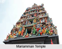 There is also a Mariamman temple at Poovirundavalli. Apart from various temples, there are three churches and a mosque was constructed by Rustom, son of Dhulfiquer of Astrabad, a servant of Nawab Jumlat-ul-mulk.
Another major temple in the district of Tiruvallur is the Lord Arulmigu Subramaniya Swami temple at Tiruttani. It is one of the six abodes of Lord Muruga. This temple is located on a hillock and has three hundred and sixty five steps. The major festivals celebrated here are Shiva Rathiri, Adi Kirthigai Theppa Thiruvizha, Shasti Thiruvizha, etc. Adi Kirthigai Theppa Thiruvizha is celebrated in mid of July and August. Lord Veeraraghava Perumal temple at Tiruvalur district is also a prominent place of pilgrimage and there is a sacred tank located very close to the temple which is called Hrittapanasini. Apart from these temples, there is another beautiful temple known as Sri Viswaroopa Panchamukha Anjaneyaswami temple which is dedicated to Sri Panchamukha Hanuman.
Temples in the district of Tiruvallur form the major centers of pilgrimage and draw a large number of devotees as well as general tourists from different parts of the state as well as various other parts of India throughout the year. Apart from the temples there are also several other places of interest in this district. Pazhayanaur is one of the villages in this district which is located at a distance of about fifteen hundred meters from Thiruvalangadu village. The contribution of Pazhayanur to the great tradition and glory of Tamils is unique. It was at this village that seventy Tamil Vellalars together sacrificed their lives to uphold a spoken work of honour. The opinion of the scholars is that nowhere could they come across such a unique incident involving the sacrifice of so many lives at an appointed hour.
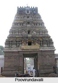 Another place of tourist interest in the district of Tiruvallur is Poovirundavalli. It is more popularly know in its corrupted form as Poonamallee, the birth place of Thirukatchi Nambi Alwar, a great devotee of Varadaraja Perumal. It is located at a distance of twenty kilometers from Chennai, on the road leading to Bengaluru (Bangalore). The name `Poovirundavalli` may be attributed to the fact that the area around, is full of jasmine flowers which are being cultivated extensively. Jasmine means `Malli` in Tamil and hence, `Poonamallee` may refer to the place where jasmine is cultivated. In Sanskrit language, the place is called Pushpakavalli. `Pushpam` means flower and `Valli` denotes Goddess.
There is another major attraction in this district which is the Poondi Reservoir. This reservoir is located in the Tiruvallur taluk. Poondi is a small village which is located about sixty kilometers away from the city of Chennai. There are frequent buses from Chennai and Tiruvallur in order to get to this place. `Poondi` the name, it is said, is derived from Poondu in Tamil, the shrub which was previously abundant at this place. Poondi has acquired a great importance as it has a huge reservoir called Sathyamurthy Sagar. The area of the reservoir is about 60.5 square miles. The water from this reservoir goes to the Red Hills tank from where the Chennai city receives water supply after undergoing necessary proceeding. This reservoir and its suburbs make an interesting picnic spot.


