
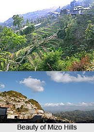
 The Mizo hills are located in Mizoram and partly in Tripura state of India. The Mizo hills are also known as the Lushai hills. They are a part of the Patkai range. The Mizo hills rise more than 2000 m (6560 ft) near the Myanmar border. Mizo hills are a treat to the eyes; they are amazingly enveloped with dense bamboo jungle and open grass covered slopes. The cherry on the top is the Tropic of Cancer runs through the heart of Mizoram, and hence, it has a pleasantly temperate climate throughout the year. These hills draw a good number of photographers, explorers and travel enthusiasts.
Inhabitants of Mizo Hills
The inhabitants of these hills are Lushais and other Mizo tribes however the population is extremely sparse. Since the early times, the Kukis were regarded as the original inhabitants of Mizo Hills. The Lushais were not heard of until the year 1840, when they invaded the district from the north.
Flora and Fauna of Mizo Hills
The Mizo hills have an outstanding view with its colourful flora and vegetation, making it an admirable place to look out for. They have widely-spread dense bamboo jungle, though at certain parts in the east smaller rainfall has given rise to open grass-covered slopes with groves of oak, pine and rhododendrons. Also in the intermontane valleys, shifting agriculture and some terrace cultivation are practiced by the people.
The Mizo hills are also home to an impressive range of fauna. The Dampa Tiger Reserve is the largest wildlife sanctuary in this hilly area. The fauna includes swamp deer, leopard, tiger, elephant and hoolock gibbon.
Attractions of Mizo Hills
The hills offer wonderful opportunities for exploration and photography. They are surrounded by amazing landscapes, rivers and waterfalls. `The Blue Mountain` is the highest peak in Lushai hills. It rises to a height of 2165 metres. Important rivers that flow through this hilly state are Tlawang, Sonai, Kolodine, Tuivawl and Kamaphuli. The Vantawang waterfalls are located close to the Thenzawl hill station. One can best explore the hills by trekking; it is an amazing way to have a glimpse of the natural wilderness here.









