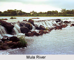
 Mula River is an important river in the Pune district of the Indian state of Maharashtra. It is dammed near the Western Ghats at the Mulshi Dam that forms the Mulshi Lake. Further downstream, in Pune city, it merges with the Pavna River on the left bank and Mutha River on the right bank to form the Mula-Mutha River, which later meets the Bhima River. Mula is a tributary of the Bhima River in the Deccan India and thus a distributory of Godavari. It passes through the towns of Pune and Khadki. The river forms the boundary between the limits of the Pimpri-Chinchwad Municipal Corporation and the Pune Municipal Corporation along the Old Pune-Mumbai Highway. Biologists have said that there are around 108 species of fish, 102 blossoming plant species, 130 bird species in and around the riverbanks and surrounding areas.
Bridges on Mula River
There are several bridges crossing the Mula River which are as follows:
•The Rajiv Gandhi Bridge connecting Pune to Ravet crosses the river at Aundh.
•The Harris Bridge crosses at Dapodi.
•The Holkar Bridge crosses the river near Khadki.
•The Sangam Bridge crosses the Mutha River at Sangamwadi, just before their merger.
Flood at Mula River
In 2010, areas surrounding the Mula River experienced flash floods due to high levels of pollution and garbage dumped into the river. The blockage in the river water flow was the main reason for the flood in the nearby regions of the Mula River.
Pollution on Mula River
In 2012, it was found that the river was not navigable from Khadki because the Maharashtra Natural Gas Limited had obstructed the flow of the river by constructing a mud path to lay a pipeline.
In 2013, it was reported that there were dead fish in the river near Wakad. Due to high levels of pollution, including of untreated sewerage water being discharged into the river by the Pune Municipal Corporation, the Maharashtra Pollution Control Board has declared the water quality to be polluted. It has also been detected by the Pune Police that marijuana plants were being grown on the riverbed near Kharadi.


