 Raidak River is one of the main right bank tributaries of the Brahmaputra River. It is a trans-boundary river and flows through countries like Bhutan, India and Bangladesh. The total length of the main river is 370 kilometres. However along with its tributaries, it covers a length of nearly 610 kilometres in Bhutan alone.
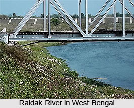
Course of Raidak River
The river rises in the Himalayas and is known as Thimphu Chhu in its upper reaches. It passes through various mountains and valleys in Bhutan. In its journey it is joined by several small tributaries flowing from nearby mountains. The river is known as the Wong in its upper course in Bhutan. The river after traversing through the mountainous terrain in Bhutan comes back to the plains in India, into the plains in Jalpaiguri district and then flows through Cooch Behar district in the state of West Bengal. After flowing in the Indian subcontinent, the river enters Bangladesh. The Raidak River merges with the Brahmaputra River within the nation limits of Bangladesh. The confluence takes place at the chainage of 327 km.
Tributary of Raidak River
An important tributary of the Raidak River is River Torso. The Torso River originates from the Chambi Valley of Tibet and it is known as the Machu in this region. The river then travels through Bhutan as Amo and then again enters India, Bangladesh and finally meets the Raidak River.
Chukha Hydel Project on Raidak River
India built a 336MW Chukha Hydel project on Raidak River in Bhutan on a turnkey basis, with India providing 60% of the capital in a grant and 40% in a loan at highly concessional terms and conditions. The construction of the project began in 1974 and completed in 1986-88.
This article is a stub. You can enrich by adding more information to it. Send your Write Up to content@indianetzone.com


